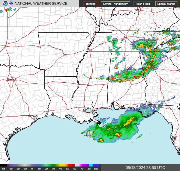


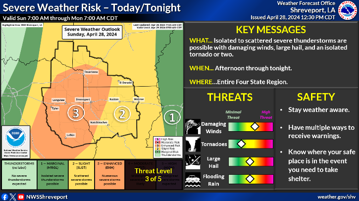
(Update): Severe thunderstorms will be possible across much of the Four State Region this afternoon and tonight. Damaging winds and large hail will be the primary threats, but a few tornadoes can't be ruled out. Also, locally heavy rainfall may result in flash flooding.
April 28, 2024 - Flood Watch In Effect Through Monday Evening
This Hazardous Weather Outlook is for south central Arkansas, southwest Arkansas, north central Louisiana, northwest Louisiana, southeast Oklahoma, east Texas and northeast Texas.
Day One: Today and tonight: A line of showers and thunderstorms will move into extreme Southeast Oklahoma, Northeast Texas, and adjacent sections of Southwest Arkansas this morning, before eventually diminishing later this morning. Locally gusty winds and brief heavy rainfall will be possible with these storms this morning, but the remnants of these storms will help focus additional shower and thunderstorm development by mid and late afternoon during peak heating, especially with the arrival of a strong upper level disturbance from the west. Some of these storms will become severe, with damaging winds, large hail, and isolated tornadoes possible, with locally heavy rainfall likely moving over the same areas. Thus, the potential for flash flooding will increase late this afternoon over Northeast Texas, extreme Southeast Oklahoma, and Southwest Arkansas, with the severe and flash flood threats shifting east into Deep East Texas and North Louisiana tonight.
Days Two Through Seven: Monday through Saturday: Showers and thunderstorms containing heavy rainfall will continue to gradually spread east across Northcentral and Northeast Louisiana Monday morning, before diminishing by afternoon. The threat for flash flooding will continue over these areas Monday morning, before ending as the rains exit the area. While a respite in the rains is expected Monday night and Tuesday morning, additional scattered showers and thunderstorms are possible across East Texas and North Louisiana Tuesday afternoon, becoming more numerous Wednesday through Friday as weak upper level disturbances traverse the area. The potential for isolated strong storms can not be ruled out with the storms Thursday and Friday, ahead of a weak cold front that will move through the region.
Spotter Information Statement: Spotter activation will likely be needed this afternoon and tonight across much of the Four State Region.