

The story headline links to a better view of the story and share features.


News
June 26, 2026 - East Lamar WSC's Consumer Confidence Report for January 1 to December 31, 2025 is now available. East Lamar WSC provides ground water from Carrizo-Wilcox Aquifer located in Center, TX, Shelby County. To view the Annual Drinking Water Quality Report, click here.
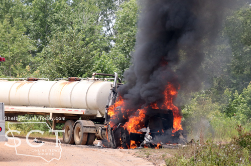
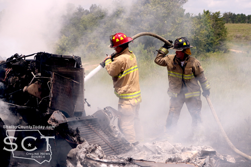
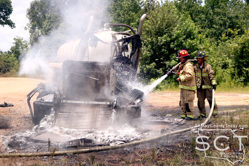
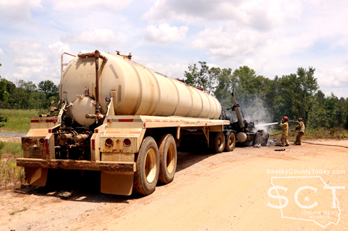
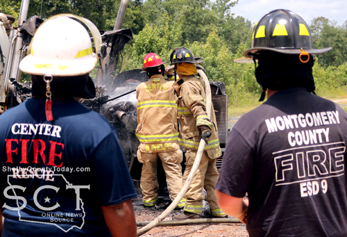
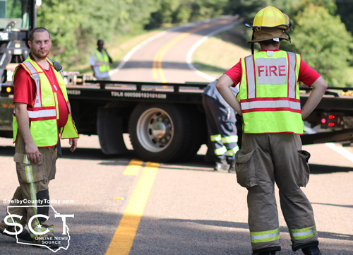
June 26, 2026 - CR 1017 was the scene of a truck tractor fire on Friday afternoon, June 26, 2026, at around 12:40pm.
Center Fire Department personnel and Texas Department of Public Safety (DPS) State Troopers responded to the location, and were met with a truck that was fully involved in the fire.
Firefighters quickly began attacking the blaze and were able to knock out the fire, preventing further spread to the trailer the truck was pulling as well as nearby woods.
The incident is under investigation by DPS and further details will be updated when they’re available.
June 25, 2026 - Flat Fork Water Supply's water Consumer Confidence Report for January 1 to December 31, 2025 is now available. Flat Fork WS provides ground water from Carrizo-Wilcox Aquifer located in Center, TX, Shelby County and ground water comes from two sources, 215 CR 4415, Tenaha and 1000 feet southwest of the plant. To view the Annual Drinking Water Quality Report, click here.
June 23, 2026 - The Texas Commission on Environmental Quality required the Sandhill public water system, 2100013, to issue a Boil Water Notice on May 26, 2026, to inform customers, individuals, or employees that due to conditions which occurred recently in the public water system, the water from this public water system was required to be boiled prior to use for drinking water or human consumption purposes.
The public water system has taken the necessary corrective actions to restore the quality of the water distributed by this public water system used for drinking water or human consumption purposes and has provided TCEQ with laboratory test results that indicate that the water no longer requires boiling prior to use as of 6-23-2026.
If you have questions concerning this matter, you may contact Alison Rhone at 936-332-4439
May 27, 2026 - Due to a line break by spectrum, the Texas Commission on Environmental Quality has required the Sandhill public water system to notify customers on 711 and highway 7 going East to boil their water prior to consumption (e.g., washing hands/face, brushing teeth, drinking, etc). Children, seniors, and persons with weakened immune systems are particularly vulnerable to harmful bacteria, and all customers should follow these directions).
To ensure destruction of all harmful bacteria and other microbes, water for drinking, cooking, and ice making should be boiled and cooled prior to use for drinking water or human consumption purposes. The water should be brought to a vigorous rolling boil and then boiled for two minutes.
In lieu of boiling, individuals may purchase bottled water or obtain water from some other suitable source for drinking water or human consumption purposes.
When it is no longer necessary to boil the water, the public water system officials will notify customers that the water is safe for drinking water or human consumption purposes.
Once the boil water notice is no longer in effect, the public water system will issue a notice to customers that rescinds the boil water notice in a manner similar to this notice.
Please share this information with all the other people who drink this water, especially those who may not have received this notice directly (for example, people in apartments, nursing homes, schools, and businesses). You can do this by posting this notice in a public place or distributing copies by hand or mail.
If you have questions concerning this matter, you may contact Alison Rhone at 936-332-443
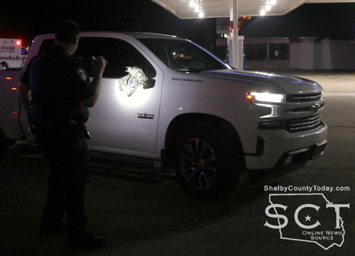
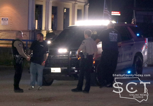
June 22, 2026 - A pedestrian was injured on Hurst Street in Center after being struck by a vehicle on Saturday, June 13, 2026.
Responders with the Center Police Department, Shelby County Sheriff’s Department and EMS responded to the scene in front of a gas station just south of the Tenaha Street intersection.
EMS personnel evaluated those involved in the incident and Center Police Officers investigated.
According to the Center Police Department (CPD), at 9:34pm officers responded to the scene when they were alerted of the auto-pedestrian crash.
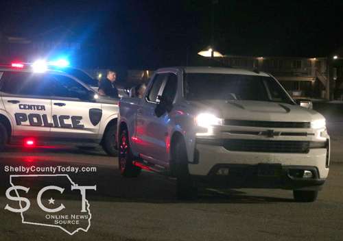
When CPD Officer Jeremy Konderla arrived, he observed a person laying on the shoulder of Hurst street with their legs in the roadway directly in front of the gas station at 1013 Hurst Street.
According to further details released by CPD, witnesses advised a white in color pickup truck hit the pedestrian. The driver of the 2021 white Chevrolet Silverado pickup truck was identified as Adrian Williams, 56, of Logansport, LA.
The pedestrian was identified as Betty Rhame, 72, of Center was transported by EMS to Nacogdoches Medical Center - Shelby Emergency Department, where she was later flown by helicopter to LSU hospital due to her injuries.
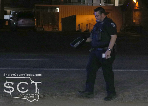
CPD reports this is an ongoing investigation as of this report. Rhame’s injuries are unknown, and they are awaiting an update from the hospital.
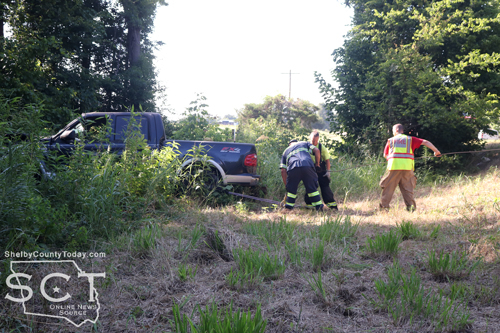
June 21, 2026 - U.S. Highway 96 South near CR 1012 was the scene of a single-vehicle crash involving a utility pole on Tuesday, June 16, 2026.
Emergency personnel with the Center Fire Department responded to the scene of the incident to aid those involved.
According to the Texas Department of Public Safety (DPS), the preliminary crash investigation indicates that at approximately 6:15am, a 2015 Chevrolet Camaro driven by David Hinton, 40, of Pineland was traveling south. It is reported that Hinton was traveling at an unsafe speed for the wet road conditions, left the road to the left, and struck a power pole.
Hinton was transported to St. Luke’s Health of San Augustine for treatment of non-life-threatening injuries.
According to DPS, this is an ongoing investigation, and no further information is available at this time.
DPS Trooper Jordan Ford investigated the incident.
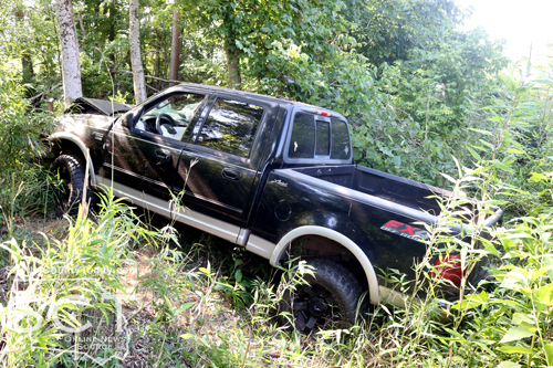
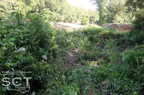
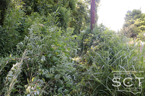
June 19, 2026 - FM 1645 Just of a mile from FM 138 was the scene of a single-vehicle crash involving a pickup truck on June 11, 2026.
Emergency personnel responded to the location of the crash incident and it was apparent upon arrival that the vehicle involved traveled off the roadway for an extensive distance before finally coming to rest against a tree.
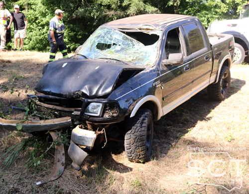
According to the Texas Department of Public Safety, at around 5pm a black 2003 Ford F-150 driven by Dillon Taylor, 31, of Garrison was northbound on FM 1645 when he stated that he fell asleep and crossed over to the wrong side of the roadway before striking a tree.
EMS personnel examined Taylor at the scene and he ultimately refused treatment.
No citations were issued at the time of the crash.
DPS personnel on scene were Trooper Cpl. Tayloir Buster and Trooper Ashley Hughes.
Timpson Volunteer Fire Department personnel assisted at the scene.

June 19, 2026 - A Marginal Risk for severe thunderstorms exists for the entire Four State Region later today through this evening, as a complex of showers and thunderstorms spread east southeast across the area. Damaging winds and heavy rainfall are the main threats.
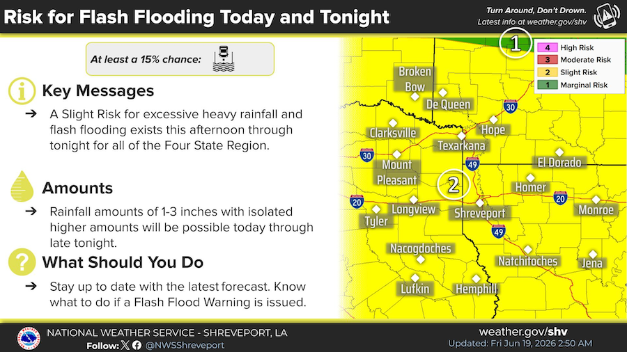
A Slight Risk for heavy rainfall and flash flooding exists this afternoon through late tonight for all of the Four State Region. Rainfall amounts of 1-3 inches, with isolated higher amounts, will be possible, which may result in flash flooding.

A complex of showers and thunderstorms will spread east southeast into the region by midday through the afternoon. Temperatures will be hottest over Deep East Texas and Central Louisiana where the storms should be later arriving, as they climb into the lower/mid 90s. Elsewhere, look for temperatures to range from the mid 80s to near 90 degrees.


June 19, 2026 - The National Weather Service issued a heat advisory at for June 19, 2026 from 12 noon until 7pm this evening.
Heat index values of 105 to 109 are expected for deep east and portions of northeast Texas and for Toledo Bend Country over into central Louisiana from noon today to 7pm this evening. Hot temperatures and high humidity may cause heat illnesses.
Precautionary/Preparedness Actions: Drink plenty of fluids, stay in an air-conditioned room, stay out of the sun, and check up on relatives and neighbors.Take extra precautions when outside. Wear lightweight and loose fitting clothing. Try to limit strenuous activities to early morning or evening. Take action when you see symptoms of heat exhaustion and heat stroke.
June 15, 2026 - DETCOG will plan to continue performing 9-1-1 addressing duties for Shelby County until January 2027.
Please contact Ezequiel Ayala via email at eayala@detcog.gov or phone at 409-381-5261.
June 3, 2026 - Due to computer repair/replacement, DETCOG will temporarily issue 9-1-1 addresses for Shelby County effective Wednesday, May 28, 2026. Please contact Benjamin Duncan, 409-381-5254.
Pages