

The story headline links to a better view of the story and share features.


News
November 3, 2023 - Let me start off by saying how thankful I am for the residents of Shelby County. Many of you I have known for my entire life, and others of you I have grown to know over the years. I am very thankful for the relationships I have gained during my time in law enforcement and as your Sheriff.
In August 2023, I underwent a double lung transplant. My progress has been steady and I am continuing to heal. This was a life-changing experience for not only me, but for my family as well. I am eternally grateful for my donor and their gift that saved my life.
At this time, my medical team does not feel it will be in my best interest to seek re-election as your Sheriff. The first year after transplant is considered critical, and I am in full understanding that I have to take care of myself. While this was not easy to hear, or accept, I trust their expertise, and know that God has a plan for the rest of my life. I put my full trust in Him, knowing that he will continue to see me through this journey.
It is my plan to be back in the office after the New Year. I still have one year to serve our as your Sheriff, and I will continue to fulfill this role to the best of my abilities. It has been a true honor to serve the citizens of Shelby County.
Please continue to remember my family and myself in your prayers during this time. We appreciate every single one of you.
Sheriff Kevin W. Windham.
November 2, 2023 - The Texas Commission on Environmental Quality required the Choice public water system, 2100005 to issue a Boil Water Notice on October 27, 2023, to inform customers, individuals, or employees that due to conditions which occurred recently in the public water system, the water from this public water system was required to be boiled prior to use for drinking water or human consumption purposes.
The public water system has taken the necessary corrective actions to restore the quality of the water distributed by this public water system used for drinking water or human consumption purposes and has provided TCEQ with laboratory test results that indicate that the water no longer requires boiling prior to use as of November 2, 2023.
If you have questions concerning this matter, you may contact, Matt Di Verdi 936-591-4346.
October 27, 2023 - Due to a broken water main the Texas Commission on Environmental Quality has required the CHOICE Water system, ID# 2100005 to notify customers that were without water October 26 and 27, 2023 on Hwy 96 S SOUTH OF 2140, Spanns Chapel area (anyone without water) to boil their water, prior to consumption (e.g., washing hands/face, brushing teeth, drinking, etc). Children, seniors, and persons with weakened immune systems are particularly vulnerable to harmful bacteria, and all customers should follow these directions.
To ensure destruction of all harmful bacteria and other microbes, water for drinking, cooking, and ice making should be boiled and cooled prior to use for drinking water or human consumption purposes. The water should be brought to a vigorous rolling boil and then boiled for two minutes.
In lieu of boiling, individuals may purchase bottled water or obtain water from some other suitable source for drinking water or human consumption purposes.
When it is no longer necessary to boil the water, the public water system officials will notify customers that the water is safe for drinking water or human consumption purposes.
Once the boil water notice is no longer in effect, the public water system will issue a notice to customers that rescinds the boil water notice in a manner similar to this notice.
Please share this information with all the other people who drink this water, especially those who may not have received this notice directly (for example, people in apartments, nursing homes, schools, and businesses). You can do this by posting this notice in a public place or distributing copies by hand or mail.
If you have questions concerning this matter, you may contact Matt Di Verdi 936-591-4346.
November 2, 2023 - Update, as of 2pm: Arnaud was arrested by Constable Pct. 3 Roy Cheatwood, and booked into the Shelby County Jail.

November 2, 2023 - The Shelby County Sheriff’s Office is seeking the whereabouts of Keith Arnaud, 40, of Joaquin. Arnaud is described as a 6’0” white male and weighs approximately 190 pounds. He has black hair and green eyes.
Arnaud has an active felony warrant for Indecency with a Child, a Felony 3 offense.
The SCSO is seeking assistance from the public in locating Arnaud. If you have any information regarding his whereabouts, please contact the SCSO (936) 598-5601.
If anyone is found to be hindering the apprehension, harboring or concealing, providing or aiding with any means of avoiding arrest or effecting escape, or warns Arnaud of impending discovery or apprehension, will be arrested and charged in accordance with Penal Code 38.05, Hindering Apprehension or Prosecution, a Felony 3 offense.
October 31, 2023 - As the first Saturday in November approaches, deer hunters are making plans to head to the woods. With increased activity in the wooded areas of East Texas, along with the cooler weather, deer and other wildlife are on the move.
Pre-dawn and just after sunset are times deer are known to be active. Stay alert when driving near wooded areas during these hours.
“The increased traffic and the scent of humans in East Texas rural wooded areas will drive deer to move, which many times means across the roadway,” said Rhonda Oaks, public information officer. “Keep your eyes on the roadway and scan the wood line and shoulders as you drive, especially during these hours.”
Follow these safety tips for driving during deer season to help you stay safe:
• Reduce speed if you see a deer near the edge of the roadway. Deer seldom move alone. If you see one deer, others could be nearby.
• When driving at night, use high beam headlights when there is no oncoming traffic. The high beams will better illuminate the eyes of the deer.
• Slow down and blow your horn with one long blast to frighten the deer.
• Brake firmly when you notice a deer in or near the road but stay in your lane. Many serious crashes occur when drivers swerve to avoid hitting a deer.
• Always wear your seatbelt.
• If your vehicle strikes a deer, do not touch the animal. A frightened and wounded deer can hurt you or further injure itself. Move your car off the road, if possible, and call 911. Remain in your vehicle. It is the safest place. Many secondary crashes occur due to pedestrians in the roadway.
For more information, contact Rhonda.Oaks@txdot.gov (mailto:Rhonda.Oaks@txdot.gov) or call (936) 633-4395

October 30, 2023 - Sheriff Kevin W. Windham reports the Shelby County Sheriff’s Office is investigating a recent theft that occurred in the 11000 block of Highway 7 W.
On Saturday, October 28, between the hours of 1am and 7am, a Polaris RZR PRO R was removed from the residence by an unknown person(s).
If you have any information regarding this theft, or you noticed anything suspicious during this time, please contact Lieutenant Investigator Chad Hooper or Investigator Aaron at the SCSO at 936-598-5601.
October 27, 2023 - A Center man has been convicted by a Shelby County Jury in the 2021 first degree murder by shooting of another man and has been sentenced to 50 years in the Texas Department of Criminal Justice Inmate Division.
The trial was prosecuted by District Attorney Karren Price, assisted by County Attorney John Price, and was held in the 273rd Judicial District Court with the Honorable James A. Payne Presiding over the trial of Justin Earl Bennett who was accused of the first degree felony murder of Deon Bailey. Jury selection began Monday, October 16, 2023, and the trial lasted until Friday, October 20.
During a “trail ride” event held on CR 2225 (new feed mill road) just off State Loop 500 outside of Center, witnesses and attorneys with the defense and prosecution retold of a physical altercation which occurred between Bennett and Bailey. After this incident occurred, Bennett left his vehicle at the trail ride and walked home where he then showered and changed clothes, before driving another vehicle back to the trail ride with a gun. Bennett and Bailey then engaged in another altercation, during which the gun Bennett brought back with him was used to shoot Bailey.
Bennett then left the scene of the shooting in the original vehicle he had gone to the trail ride in with his cousin. Three days later, Bennett turned himself in at the Sheriff’s Department without incident. According to a video recorded interview between Bennett and Sheriff’s Department Investigators Chad Brown and Jimmy Wagstaff, Bennett claimed he had been hiding in the woods for three days and during that time had thrown the gun somewhere near a body of water.
The jury heard from the defense presented by Attorney Clay Thomas, representing Bennett, and presented through witness testimony the possibility Bailey also had a gun at the trail ride; however, neither the gun Bennett used to shoot Bailey nor the one Bailey was suggested to have possessed were ever located.
The jury deliberated for just under an hour over the guilt or innocence of Bennett, and came back with a verdict of guilty. The jury returned to the jury room once again to deliberate over the sentencing phase and after 27 minutes returned with a sentence of 50 years in prison. Bennett was then remanded to the custody of the Shelby County Sheriff until transport to the prison system.
October 27, 2023 - State Highway 87 North near CR 4031 was the scene of a major crash which resulted in the death of one driver involved on Thursday, October 26, 2023.
Timpson Volunteer Fire Department responded to the scene of the incident just under a mile south of Timpson with additional law enforcement officials to assist those involved.
According to information provided by the Texas Department of Public Safety (DPS), the preliminary crash investigation indicates that at approximately 8:48pm, a 2014 Chevrolet Malibu driven by Courtney Handlin, 33, of Mount Enterprise was traveling south and struck a large branch that had fallen in the roadway. After striking the branch, the Chevrolet traveled to the shoulder of the road. It is reported that a 1997 Ford F-350 driven by Brittany Chavis, 29, of Silsbee was also traveling south and struck the branch, causing a piece of it to come through the windshield and strike the driver. After striking it, the Ford continued forward and sideswiped the Chevrolet and traveled into a ravine.
Handlin was not injured.
Brittany Chavis was pronounced deceased on scene by Tracy Broadway, Justice of the Peace for Precinct 5.
Chavis’ passenger, Melvin Chavis, 29, was not injured.
DPS reports this is an ongoing investigation, and no further information is available.
Taylor Funeral Home transported Brittany Chavis from the scene.
The crash was investigated by DPS Trooper Tim Grace, assisted by DPS Sgt. Aaron Shelton.
October 26, 2023 - On October 24, 2023 the Texas Commission on Environmental Quality required the Five Way public water system, 2100008 to issue a Boil Water Notice to inform customers, individuals, or employees that due to conditions which occurred recently in the public water system, the water from this public water system was required to be boiled prior to use for drinking water or human consumption purposes.
The public water system has taken the necessary corrective actions to restore the quality of the water distributed by this public water system used for drinking water or human consumption purposes and has provided TCEQ with laboratory test results that indicate that the water no longer requires boiling prior to use as of October 26, 2023.
If you have questions concerning this matter, you may contact, Matt Di Verdi @ 936-591-4346
October 24, 2023 - Due to a broken water leak the Texas Commission on Environmental Quality has required the Five Way Water system, ID# 2100008 to notify customers that were without water October 23, 2023 on FM 414, Sardis, Campti area (anyone without water) to boil their water, prior to consumption (e.g., washing hands/face, brushing teeth, drinking, etc). Children, seniors, and persons with weakened immune systems are particularly vulnerable to harmful bacteria, and all customers should follow these directions.
To ensure destruction of all harmful bacteria and other microbes, water for drinking, cooking, and ice making should be boiled and cooled prior to use for drinking water or human consumption purposes. The water should be brought to a vigorous rolling boil and then boiled for two minutes.
In lieu of boiling, individuals may purchase bottled water or obtain water from some other suitable source for drinking water or human consumption purposes.

When it is no longer necessary to boil the water, the public water system officials will notify customers that the water is safe for drinking water or human consumption purposes.
Once the boil water notice is no longer in effect, the public water system will issue a notice to customers that rescinds the boil water notice in a manner similar to this notice.
Please share this information with all the other people who drink this water, especially those who may not have received this notice directly (for example, people in apartments, nursing homes, schools, and businesses). You can do this by posting this notice in a public place or distributing copies by hand or mail.
If you have questions concerning this matter, you may contact Matt DiVerdi at 936 591 4346.
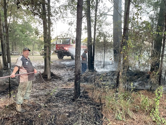
Brush fire on County Road 3790 on Thursday
October 23, 2023 - Over the week of October 15th through 21st the Joaquin Volunteer Fire Department had 5 calls. Here’s a summary of the week’s events.
Sunday at 2:19pm a call came in for a person having a panic attack in their car on Highway 84 East. The patient had pulled over to the side of the road when they called emergency services. The JVFD medical team and Allegiance EMS responded to assist the patient.
Wednesday at 1:51pm a page was received for a brush fire caused by a burn pile at a residence on Highway 7 East. An hour later at 2:51pm another page came in for a brush fire on FM 139 with the same cause. In both cases the JVFD responded with brush trucks to put out the flames and stop the spread.
Thursday at 11:51am a call came in for a medical alarm at a residence on FM 3082. The Joaquin VFD med team and Allegiance EMS responded help the person that had pressed the alarm.
Thursday evening at 6:02pm a page came in for another brush fire near a home on County Road 3790. The JVFD responded with a couple brush trucks and was able to get the fire under control in about 30 minutes.
With that, this edition of the report will come to a close. The Joaquin Volunteer Fire Department hopes everyone has a great and safe week ahead.
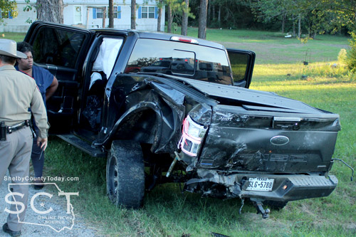
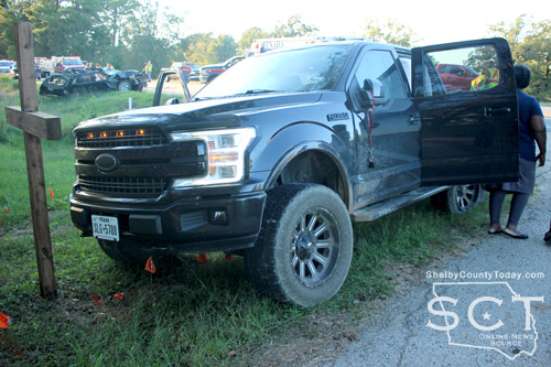
October 19, 2023 - U.S. Highway 84 at the intersection of CR 4475 outside of Tenaha was the scene of a major four-vehicle crash Wednesday, October 18, 2023.
Emergency personnel with the Tenaha Volunteer Fire Department was immediately dispatched to the location, as well as medical and law enforcement personnel.
Upon arrival, vehicles involved were at multiple locations and fire personnel needed to use extrication equipment to help remove the driver of one car from the vehicle she was driving.

According to Texas Department of Public Safety State Trooper Dustin Ramos, at 5:14pm a white 2018 Ford Expedition driven by Jeffrey Kater, 51, of Joaquin was stopped behind an uninvolved vehicle facing eastbound waiting to turn left on CR 4475. At that time a black 2019 Ford F150 driven by Solomon Washington, 30, of Tenaha was stopped behind the Expedition
A black 2010 Ford Edge driven by Gaye Daw, 63, of Joaquin was eastbound and failed to control speed, striking the rear of the F-150 which subsequently collided with the rear of the Expedition.
The Edge then spun into the westbound lane where a tan 2007 Peterbilt pulling a 2012 flatbed, both owned by Southern Transport LLC of Gladewater and driven by Charles Thompson, 60, of Overton was westbound and struck the Edge. The truck tractor traveled off the roadway into the wood line on the eastbound side and the Edge came to rest on the eastbound shoulder.

Daw was transported to Nacogdoches Medical Center - Shelby Emergency Department for treatment of her injuries. Thompson, and Washington were also transported to the same facility for minor injuries.
Daw was issued a citation for failure to control speed.
The crash remains under investigation.
Trooper Ramos was assisted at the scene of the crash by Shelby County Sheriff's Department, Constable Taylor Fanguy and Constable Roy Cheatwood.


Pages