

The story headline links to a better view of the story and share features.


News
February 13, 2023 - Over the week of February 5th through 11th the Joaquin Volunteer Fire Department had just 2 calls, with both coming in on Wednesday. Here’s a summary of the week’s events.
Wednesday morning at 7:51am the JVFD was called to assist with a potential DOA on the Doogieville Loop. It was quickly discovered that this was the scene of a crime and a investigation was opened by law enforcement. At this point there was not much that the JVFD could do and they were cleared from the scene. The suspect was brought into custody later in the evening.
Later Wednesday night at 8:58pm a call would be received for a diabetic patient possibly going into a diabetic coma on Childress Street. Members of the EMR team responded to check out the patient and Allegiance EMS arrived shortly thereafter. The patient was then loaded into the ambulance where they could be transported to a nearby emergency room.
With that, this report will come to a close. The Joaquin Volunteer Fire Department hopes everyone has a great and safe week ahead.
February 10, 2023 - The Center City Council will meet in Regular Session on Monday, February 13, 2023 at 5pm in Council Room at Center City Hall. The following items are on the agenda for appropriate action:
I. Welcome Guests and Visitors.
II. Public Hearing
A. Zoning Application 2023-1 -- Specific Use Permit at 637 Railroad Ave
III. Approval of Minutes
A. Regular meeting on January 9, 2023
IV. Discuss Consider and Action on the Following:
A. Ordinance 2023-01 Amending the Zoning Ordinance for Specific Use Permit at 637 Railroad Avenue
B. Resolution 2023-05 TCEQ Water Rights Permit Signatory
C. Resolution 2023-06 Texas SmartBuy Membership
D. Resolution 2023-07 Authorizing Adjustment to Benefit Waiting Period
E. Declaring Surplus Property
F. Request for City Membership
1. Texas Forest Country Partnership
2. Pineywoods Resource Conservation & Development Corp.
V. Items of Interest from Council and City Manager and Citizens – No Action Items.
A. Quarterly Cash & Investment Report
VI. Executive Session
Consider entering executive session for legal consultation with the City Attorney and discussion of pending litigation, personnel matters and land acquisition with possible action related thereto upon reconvening in open session in accordance with Government Code Section 551.071, 551.072 and 551.074
VII. Adjournment.

February 9, 2023 - Shelby County Sheriff Kevin W. Windham reports the arrest of Carlos Caporali Manuels, 32, of Joaquin.
On Wednesday, February 8, 2023 at approximately 7:46 a.m., a call came in through 9-1-1 from an individual who stated a child was at her home saying his mother was deceased in their home. Deputies responded to the scene, located on Doogieville Loop in Joaquin, and found 32-year-old Yuri Diana Barahona, of Joaquin, deceased from what appeared to be gunshot wounds to the head.
Investigators secured the scene and began searching for Manuels due to information received that he had packed up and left.
At approximately 2 p.m., Tyler Police Department located Manuels 1998 Chevrolet S-10 abandoned at the intersection of Valentine and N Spring Avenue in Tyler.
At 5:51 p.m., Manuels called Smith County 9-1-1 stating he had been shot, and was requesting medical care. Manuels was transported to CHRISTUS Mother Frances Hospital in Tyler, and treated for his injuries. It was determined that the injuries sustained to his face were from a pellet gun.
Sheriff Windham sent investigators to the hospital to interview Manuels and take him into custody. Once he was released from the hospital, Manuels was transported to Smith County Sheriff’s Office jail facility and booked for Murder (F-1). Manuels has since been transported to the Shelby County jail where he is currently awaiting arraignment.
The SCSO would like to extend a huge thank you to Desoto Parish Sheriff Jaysen Richardson and his staff for the use of their mobile command center; Joaquin ISD staff for the compassion towards the victim's children; Golden Eye Clinic; Shelby County Children’s Advocacy Center; Tyler Police Department; Smith County Sheriff’s Office; Shelby County Constables - Zack Warr, Jamie Hagler, Roy Cheatwood, Taylor Fanguy, and Josh Tipton; Texas Department of Public Safety Trooper Taylor Buster; Texas Ranger Jim Hicks; Tenaha Police Department; Joaquin First Responders; and Shelby County District Attorney Karren Price.
Ms. Barahona’s children are being cared for by an immediate family member. We extend our condolences to the Barahona family. You are in our thoughts and prayers.

February 8, 2023 - At 7:49pm, Sheriff Kevin W. Windham reports the successful capture of Manuels without incident in Tyler.
February 8, 2023 - Sheriff Windham reports, as of 4:25pm, the person of interest has been upgraded to a suspect in their investigation. The vehicle they were searching for has also been located in Tyler and Tyler Police Department has taken possession. Carlos Caporali Manuels is considered armed and dangerous.
Anyone with information about his whereabouts, or who has seen him should contact local law enforcement immediately. The Shelby County Sheriff's Department can be reached at 936-598-5601.
February 8, 2023 - Sheriff Kevin W. Windham reports that the Shelby County Sheriff’s Office is currently working a possible homicide on Doogieville Loop in Joaquin.
The SCSO is seeking the whereabouts of Carlos Caporali (Carlos Caporali Manuels) who is a person of interest in this case.
Carlos is believed to be driving a white 1998 Chevrolet S-10 bearing Texas plate PVL 8948.

If you have any information in regards to Carlos’ whereabouts, you are urged to contact SCSO Lieutenant Investigator Chad Hooper at 936.572.5045 or the SCSO at 936.598.5601.
No further information will be released at this time.

February 9, 2023 - West Shelby County Volunteer Fire Department (WSCVFD) had three calls lately outside of those worked with Center Fire Department.
There was a crash on Highway 7 on the downhill side of Mcswain Hill January 28 at 7:30pm where a dead tree fell across the road and a gray GMC collided with the tree. There were no injuries but the truck was towed away.
WSCVFD provided traffic control for a vehicle stuck in the ditch on Highway 7 February 2 near Aiken after one of the many rain storms we’ve had recently.
Finally on February 2 at 6:45am WSCVFD responded to a grass on County Road 1187 that was caused by a downed power line. Firefighters managed to knock it out before it spread too far.

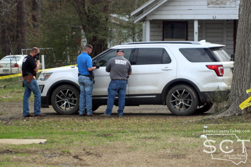
Shelby County Sheriff Kevin W. Windham and DeSoto Parish Sheriff Jayson Richardson are seen conferring with Investigator David Haley and Investigator Aaron Jones.
February 8, 2023 - At 7:49pm, Sheriff Kevin W. Windham reports the succesful capture of Manuels without incident in Tyler.
February 8, 2023 - The search continues for a suspect in the death of a woman that was discovered in Joaquin on Doogieville Loop on Wednesday morning, February 8, 2023.
Shelby County Sheriff Kevin Windham has indicated as of 4:25pm the person of interest in the case has been upgraded to a suspect in what has been determined to be a homicide. He confirmed the victim to be a hispanic female.
Carlos Caporali Manuels
Carlos Caporali Manuels is being sought and the vehicle he was driving, a white 1998 Chevrolet S-10, was discovered Wednesday in Tyler where it was abandoned with the doors locked. Tyler Police Department has taken possession of the vehicle for processing. Manuels is considered armed and dangerous, and anyone seeing him should contact local law enforcement. The Shelby County Sheriff’s Department can be reached at 936-598-5601.
The Sheriff’s Department was contacted at 7:46am when a neighbor called for help, “a lady called and said that the neighbors kids, one of the children, there were four children inside the residence. One of the children came next door and told them that their mother was dead inside the house,” said Sheriff Windham.

Sheriff Kevin W. Windham (left) is seen speaking with Lt. Investigator Chad Hooper (right).
Sheriff’s Department Deputies have been investigating the scene and Shelby County Constables were searching for the suspect in the area.
Texas Ranger James Hicks arrived and combined efforts with local law enforcement in investigating the incident.
Melba Rodgers, Justice of the Peace Precinct 3, pronounced the victim deceased at the scene and Watson & Sons Funeral Home transported her.
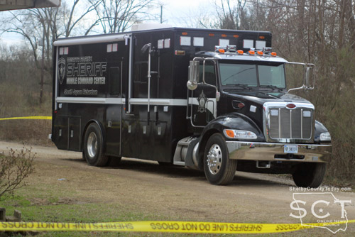
DeSoto Parish Sheriff's Department shared their mobile command center in assisting with the investigation.
Sheriff Windham said how grateful he is to Sheriff Jayson Richardson with DeSoto Parish Sheriff's Department for supplying their mobile command unit to assist in the investigation and in preparation for the anticipated inclement weather.

Investigators are seen preparing to enter the house where the victim was located.

The incident took place on Doogieville Loop in Joaquin.


Tenaha Police Chief Scott Burkhalter assisted in gaining access to the vehicle which belonged to the victim.
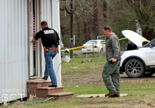
Lt. Investigator Chad Hooper is seen entering the residence with Texas Ranger James Hicks.

Texas Ranger James Hicks is seen discussing information with area investigators and constables.
February 8, 2023 - On February 1, 2023, the Texas Commission on Environmental Quality required the Choice public water system, 2100005 to issue a Boil Water Notice to inform customers, individuals, or employees that due to conditions which occurred recently in the public water system, a broken main on highway 96 north of 417, the water from this public water system was required to be boiled prior to use for drinking water or human consumption purposes.
The public water system has taken the necessary corrective actions to restore the quality of the water distributed by this public water system used for drinking water or human consumption purposes and has provided TCEQ with laboratory test results that indicate that the water no longer requires boiling prior to use as of February 8, 2023.
If you have questions concerning this matter, you may contact, Matt Di Verdi 936-591-4346.
February 1, 2023 - Due to a broken water main the Texas Commission on Environmental Quality has required the CHOICE Water system, ID# 2100005 to notify customers that were without water February 1, 2023 on Hwy 96 north of 417,(anyone without water) to boil their water, prior to consumption (e.g., washing hands/face, brushing teeth, drinking, etc). Children, seniors, and persons with weakened immune systems are particularly vulnerable to harmful bacteria, and all customers should follow these directions.
To ensure destruction of all harmful bacteria and other microbes, water for drinking, cooking, and ice making should be boiled and cooled prior to use for drinking water or human consumption purposes. The water should be brought to a vigorous rolling boil and then boiled for two minutes.
In lieu of boiling, individuals may purchase bottled water or obtain water from some other suitable source for drinking water or human consumption purposes.
When it is no longer necessary to boil the water, the public water system officials will notify customers that the water is safe for drinking water or human consumption purposes.
Once the boil water notice is no longer in effect, the public water system will issue a notice to customers that rescinds the boil water notice in a manner similar to this notice.
Please share this information with all the other people who drink this water, especially those who may not have received this notice directly (for example, people in apartments, nursing homes, schools, and businesses). You can do this by posting this notice in a public place or distributing copies by hand or mail.
If you have questions concerning this matter, you may contact Matt Di Verdi 936-591-4346
February 7, 2023 - Center ISD will resume its normal schedule on Wednesday, February 8, 2023.
February 6, 2023 - Center ISD has begun disinfecting all buildings and buses. This is an extensive process and will take two days. Once the process has begun, no adults or students will be allowed inside any building or bus until it is safe to re-enter.
Center ISD will make an announcement regarding when it is safe to re-enter. Center ISD is cancelling classes for tomorrow, February 7, 2023 also. All indoor practices are cancelled until further notice. It is imperative that everyone stay out of the buildings until we make an announcement that it is safe to re-enter.
Dr. Brian Morris, Superintendent
February 5, 2023 - Center ISD has just been notified of an employee who was diagnosed with spinal meningitis over the weekend. Out of an abundance of caution, Center ISD is closing all campuses tomorrow, Monday, February 6, 2023 for disinfection purposes.
Dr. Brian Morris, ,Superintendent

Click image to view larger
February 6, 2023 - The U.S. Forest Service will be performing a prescribed burn today, February 6, 2023, and they have provided the following information on the location and time of the burn:
Angelina/Sabine National Forest, Bannister West Rx, Compartment 11, 16
- Date: February 6, 2023
- Ignition Time: 1100
- County(s): San Augustine
- Location: Bannister West
- Smoke: Winds are out of the South and drift smoke may be noticeable In
- Forest and Unit: Angelina, Bannister West, 14,16
- Size: 642 Acres
- Type: (Hand, UAS)
- Est. Completed Time: 1800
Smoke will impact areas around the prescribed burn, and long-range drift smoke may be present during and after ignition operations.
Please drive with caution. Ground personnel will be operating in the area and smoke may impact visibility on local roads and highways near the burn unit.
For more information, contact the Angelina Sabine Ranger District at (936) 897-1068 or (409) 625-1940
U.S. Forest Service Prescribed Burn Tracker:
Southern Region Prescribed Burn Accomplishment Tracker (arcgis.com)
February 6, 2023 - The week of January 29th through February 4th yielded another four calls for the Joaquin Volunteer Fire Department. Here’s a summary of the week’s events.
Tuesday at 6:39pm a call was received for someone having an allergic reaction on FM 2694 in Shelbyville. Allegiance EMS requested that the JVFD EMR team respond to the location, which was out of jurisdiction, due to the EMRs having the necessary medication and being closer at the time of the call. Once the EMRs arrived on the scene they found that patient was in a stable condition and did not require an emergency dose of epinephrine. After checking that the patient’s vitals were within normal range, the EMRs were able to clear the scene.
Wednesday at 5:55pm a call came in for a man in the river on County Road 3545. At the time of the call the temperatures outside were in the thirties and it was clear if the man stayed in the water too long that hypothermia would set in so, in addition to Joaquin’s response, DFD1 (DeSoto Fire District) deployed a boat to assist in getting him out of the water. Upon arriving at the address it was discovered that the man had been helped out of the river by some neighbors and he was warming up in his home. To be on the safe side, he was checked out by EMRs and Allegiance EMS and they did not find that he was suffering from any effects of hypothermia.
Later Wednesday night at 9:03pm a call was received for a female having a seizure on County Road 3173. The EMRs responded and were able to help DeSoto EMS with getting the patient to the ambulance where she could be transported to an emergency room.
Thursday had the final call for the week at 11:10am when it was reported that a car had ran off of Highway 7 East near Flat Fork Creek. When the JVFD made it to the scene, they found the car in the upright position stuck in the mud a fair distance off the pavement. The three occupants were all unharmed and had called for help to get their car unstuck. Once a tow truck was en route to the location, the JVFD was able to clear the scene.
With that, this edition of the report will come to a close. The Joaquin Volunteer Fire Department hopes everyone has a great and safe week going forward.
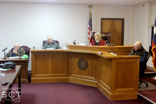
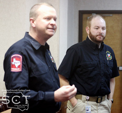
February 3, 2023 - The Texas Division of Emergency Management (TDEM) introduced its new liaison officer for Shelby County to the Shelby County Commissioners during their meeting held Wednesday, February 1, 2023.
Jon Clingaman, Jr. TDEM District Coordinator introduced Seth Shrell as the County Liaison Officer for Shelby County and he described the purpose behind the TDEM’s efforts to place officers around the state.
“His primary responsibility is to represent TDEM on blue sky days and on disaster times for Shelby County,” said Clingaman.
Clingaman explained there is no cost to the county to have this officer. According to Clingaman the TDEM Chief, W. Nim Kidd came to understand there were a lot of people unaware of what TDEM was and questions people may have had were not able aways to be answered quickly. Clingaman compared the new TDEM County Officer to that of an AgriLife Extension Agent in concept.
“Chief Kidd’s vision is to have 100 county liaison officers across the state of Texas,” said Clingaman. “By adding these liaison officers that puts either a TDEM person representative in every county or contiguous county across the state of Texas.”
Shrell is a resident of Shelby County and currently is working out of the Precinct 1 Justice of the Peace office while he works with Luciana Barr, Shelby County Emergency Management Coordinator, and there are plans for him to move his office to the same one where the 911 addressing administrator is currently housed in the courthouse.
Clingaman described how helpful Shrell already proved to be during water outage issues the Paxton/Jackson Water system had in being without water. Clingaman described how they are not in Shelby County to be critical of local government, but to be a help when needed.
Shrell shared he is from Timpson and grew up in the area and is invested in helping provide positive outcomes for the area. Communication with Barr, EMC; and Judge Harbison has already highlighted some areas which need to be bolstered and he hopes to help keep the “ball rolling” on those items.
“Anything else you guys can think of that I can help with, let me know,” said Shrell.
According to Clingaman, Shrell will be working to bring area partners together and help them to meet all obligations with documentation for funding among other ways he may be able to assist with food banks and other entities.
“His goal is to be out identifying these partners such as school district partners, your local fire department partners, helping them understand the importance of documentation for reimbursement under federal and state disasters,” said Clingaman. “As you all know the federal thresholds continue to creep up, and when we say creep at that level it’s millions of dollars that it keeps going up.”
Judge Harbison asked Shrell to share some of his history and he stated he worked for four years as an EMT and paramedic around 12 years ago, before working off shore as a paramedic and then in the oilfield for a short time. After that he was with the Texas Forest Service in 2015 as a Natural Resource professional advising land owners, with wild land firefighting management teams and as a commissioned law enforcement officer for them before joining TDEM in December 2022.
A motion carried by the commissioners to approve an Interlocal agreement between Shelby County and Texas Division of Emergency Management for office space.

Bobby Pigg, Shelby County Appraiser, gave an update to the commissioners on the project to combine the servers of the Shelby County Tax office and Shelby County Appraisal District office into one server.
“The fiber line has been run to the tax office, and to my office and where we are right now is we’ve got a gentleman, Joey Orellana, is supposed to get the connections ready for Harris-Govern to come down,” said Pigg. “There have to be some converters in place to run the line to the server itself.”
Clint Porterfield, County Auditor, listed several items that are considered a shared expense for the project, which according to Porterfield include three numbers that total $28,583.
“$7,500 was the cost of the CAD to run their fiber line and they have requested that we pay half of that,” said Porterfield. “The $20,000 is the server, and the $1,083 is the IT services. I would just say this, in response to their request for us to pay half of their fiber line, we’re both saving money on this so I don’t think it would be an issue for us to do that.”
Porterfield further explained the county would pay the whole cost amount up front and then be reimbursed, this would include the total amount on the county’s asset listing and for insurance purposes to cover the contents of the building.
“We did not budget this for this year, we did not budget this for this year; however, we even last year talked about using contingency and those funds are available this year we can pay this out of our contingency and set up the asset from there,” said Porterfield.
Judge Harbison highlighted the savings to the county by purchasing one server for the two county entities to use and the need for each to have a new server with the tax assessor/collector needing one now, and the county appraisal district needing one in the near future. The initial savings are expected to be around $10,000.
“It’s going to be a savings to both the CAD and the county, which when we save the CAD money we save all the taxing entities money,” said Judge Harbison. “
Pigg also noted the addition of the city of Center to the fiber line, and so three local entities are expected to benefit from the connection.
A motion carried to approve the purchase order to move forward with the project.
The commissioners approved a $1,000 donation from the city of Timpson for the benefit of Constable Josh Tipton for installation of a computer system in his patrol vehicle.
“This equipment is equipment that we bought him. He is just wanting to get TCOLE to install that for him, instead of just somebody locally,” said Judge Harbison. “The city of Timpson agreed to have that installation done.”
A motion carried to accept the donation from the city of Timpson to Constable Tipton Precinct 5.
During the meeting the commissioners approved a motion to accept a $15,000 grant from the Sabine River Authority to be used for expenses incurred during the 2022 Holiday freeze event.
Judge Harbison said she has received both the check for that amount and a “stack” of bills. She also said Luciana Barr, Emergency Management Coordinator, has been in contact with both the city of Joaquin and the Paxton/Jackson Water Supply and as a result she explained the county is going to need to go over the combined bills to find out what bills need to be paid.
Stevie Smith, Commissioner Precinct 3, commented to Judge Harbison it grant would remain afterward, and Judge Harbison retorted if all the bills are paid, there won’t be any money remaining.
“The bills I got, Paxton was up to about $16,000 and city of Joaquin was about $7,[000] or $8,000 and we need to discuss with them and also with Seth on what the understanding of what that was to go for,” said Judge Harbison.
Judge Harbison stated it was her understanding the funds were intended to pay for purchased water, bottled water, as well as people to help.
“More than likely the whole $15,000 will be expended,” said Judge Harbison.
A motion was made by Roscoe McSwain, Commissioner Precinct 1, to accept the check and put it into the contingency fund. Porterfield then interjected a recommendation of putting the funds into a donation account for clarity in tracking the use of funds.

The meeting went into an executive session at 10:10am and returned to open session at 11:04am.
Judge Harbison stated there were a variety of issues spoken on during executive session and they will all be put on next weeks agenda.
“We just met with council and got some legal advice on some things, so we’ll have that open for discussion next week,: said Judge Harbison.
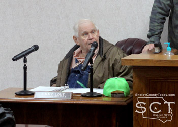
The meeting adjourned at 11:05am after which Judge Harbison expressed how glad she was to see Jimmy Lout, Commissioner Precinct 2, back as he has been away due to medical reasons.
Agenda items approved during the meeting include:
1. Pay weekly expenses.

2. Current payroll.

3. Interlocal Agreement between Shelby County and Texas Division of Emergency Management for office space.

4. Move forward with the merge of one server for Tax office and CAD.

5. Donation of $1,000 from the City of Timpson for the benefit of Constable Josh Tipton for installation of the computer system in his patrol vehicle.

6. Receipt of the $15,000 grant from the Sabine River Authority to be used for expenses incurred during the 2022 Holiday freeze event.

7. Shelby County to participate in the Texas Association of Counties Cybersecurity program. This program will put the County in compliance with Texas Government Code §2054.5191 which requires all county employees, elected officials, and appointed officials who have access to a local government computer system or database and use a computer to perform at least 25% of their duties to complete an annual cybersecurity training that has been certified by the Texas Department of Information Resources. The training has been administered by the County Treasurer the past 2 years.

8. Adjourn at 11:05
Pages