

The story headline links to a better view of the story and share features.


News
December 2, 2022 - The Shelby County Sheriff’s Office is requesting the community’s assistance in identifying the suspects involved in two separate criminal mischief incidents that occurred on Friday, November 25, 2022, in the area of County Road 4688 and FM 947. Both incidents involved a rock being thrown at the residences, causing damage to windows.
One residence had surveillance video footage that shows a vehicle stop at the end of the driveway. A white male is observed running up the driveway barefooted, and further observed to throw an object through the kitchen window. It is further observed that there were three subjects in total that exited the vehicle, with two that remained at the end of the driveway, while the aforementioned male ran up to the house to throw the object, which was identified to be a rock.
If you have any information regarding this case, please contact Captain DJ Dickerson at 936.572.0255.
December 1, 2022 - Josh Ritter, Justice of the Peace Precinct 4, is officially being removed immediately by suspension from his office December 1, 2022, per an order filed by Karren Price, 123rd Judicial District Attorney, and signed by Leann K. Rafferty, 123rd Judicial District Court Judge.
 On this date (December 1, 2022) the Court reviewed the original petition for the removal of Joshua Ritter from the office of JP Pct. 4, Shelby County, Texas.
Having already granted the order for issuance of citation in this case, it is ordered, adjudged, and decreed that Joshua Ritter is immediately removed from the office of Shelby County Justice of the Peace Precinct 4, immediately upon the signing of this order.
Several issues are addressed in the initial petition filed by Price with the most notable being an allegation of misconduct against Ritter for meeting with Ethan Myers who was recently arrested and charged with 1st degree murder in the death of Sarah Hopson on November 13, 2022.
Ritter was served with the petition on Wednesday, November 30, 2022. Shelby County District Attorney Karren Price filed a petition on November 29, 2022 in the 123rd Judicial District Court of the Honorable Leanne K. Rafferty for the removal of Joshua Ritter from the office of Justice of the Peace Precinct 4, Shelby County. The petition alleges incompetence and/or official misconduct as defined in the Texas Local Government Code 87.011(3) and 87.011(2)(A)&(B).
Josh Ritter was appointed Justice of the Peace for Precinct 4 during the Commissioners Court meeting held Wednesday, March 30, 2022 to fulfill the remainder of Judge Jackie Kirkwood’s term following his passing on January 29, 2022. The appointment term would have ended the end of 2022. Josh Ritter ran unopposed becoming a declared elected candidate in the November General Election.
The allegation of incompetence in the petition is detailed to be failure of JP Ritter to file reports of the activity in his office, including any monies collected, twice monthly with the County Treasurer. An example given was JP Ritter filed a report at the end of July 2022 and did not file another report nor turn in collected funds to the County Treasurer until the end of September 2022. The next report filed wasn’t until the end of October and then another on November 28, 2022. The petition reports any attempts to rectify the reporting timeline as well as accuracy of the reports has failed. The petition also mentions complaints from officials regarding being able to contact JP Ritter when on call or the public regarding current and delinquent tickets.
Official misconduct alleges an incident on or about November 28, 2022 in which JP Ritter entered the Shelby County Sheriff’s Office and Detention Center and directed the jail personnel to bring an inmate to him for interview, knowing the incarcerated individual was represented by counsel who was not present during the interview. JP Ritter is a licensed Texas lawyer, charged with knowledge of every inmate’s Constitutional Rights, State and Federal, and yet he failed to follow the law he is sworn to uphold and admitted same when asked by D.A. Price. The inmate interviewed by JP Ritter was Ethan Myers who was incarcerated on 1st degree felony charge of murder, a case currently under investigation.
In the petition, D.A. Price is seeking the immediate suspension of Joshua Ritter from office because of his acts of misconduct and /or incompetence in performing his statutory and Constitutional duties as required of any office holder. Along with suspension, District Attorney Price seeks the appointment of a person as JP Pct. 4, Shelby County pending further order of the Honorable Court.
Price was available to comment on the circumstances leading up to this suspension.
"No one ever wants to have to file a removal action on another office holder," said Price. "In this instance I'm just fearful that I can't trust that he'll follow the law, and if he doesn't know what the law is, that he will call."
Price stated she has offered to all of the Justice of the Peace anytime they don't know something to call and ask someone, including herself anytime.
"[He] has not reached out, not made any effort, so it leaves me with no choice," said Price.
Related articles:

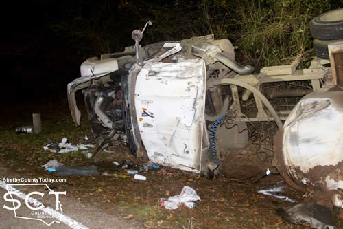
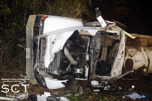
December 1, 2022 - FM 3172 near CR 2665 was the scene of a fatal crash November 30, 2022, involving a truck-tractor hauling saltwater.
Emergency personnel with four fire departments including the Huxley Volunteer Fire Department (VFD), Shelbyville VFD, Joaquin VFD and Center Fire Department immediately responded to the scene when they were alerted to the incident two miles from FM 2694.
Fire personnel from all departments worked together to extricate the driver from the truck involved in the crash. Additional fire department personnel, as well as Shelby County Sheriff's Deputies directed traffic away from the scene while emergency efforts were performed and Texas Department of Public Safety investigated the crash.
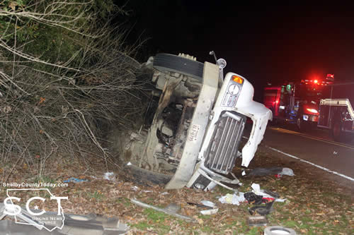
According to Texas Department of Public Safety (DPS) the preliminary investigation indicates that at approximately 3:48pm, a white 2003 Mack truck tractor semi-trailer driven by Deantre Burns, 22, of Joaquin was traveling west. It is reported that Burns failed to drive in a single lane and traveled into the west ditch, at which point it overturned.
Burns was pronounced deceased on scene by Donna Hughes, Justice of the Peace Precinct 1. Watson & Sons Funeral Home transported Burns from the location.
Investigating the crash was DPS Trooper Sgt. Aaron Shelton.
Additional units providing emergency support were Jamie Hagler, Precinct 2 Constable; and Roy Cheatwood, Constable Precinct 3.

Officers with Department of Family and Protective Services were present during the meeting for the proclamation declaring November as Adoption Month.
November 29, 2022 - The Shelby County Commissioners approved the receipt of a donation of funds for road work from a company building a sub-division in Precinct 1 during their meeting held November 2, 2022.
The commissioners discussed the potential $35,000 dollar donation to Road and Bridge Pct. 1 from LSLP Forest Ridge LLC for the purpose of improving and maintaining County Road 1060 and Roscoe McSwain, Commissioner Precinct 1, elaborated on the donation. He explained a portion of a sub-division had been developed approximately a mile and 7/10 with mostly timber plantation beside the road and high banks along the roadway, with poor drainage.
Forest Ridge LLC. has allowed McSwain to go in and remove the slopes from the high banks and timber off the road leaving a 40-50 foot right of way for the county.
"They've agreed to come back and donate $35,000 to my precinct to rock this road after we do the roughing in and getting the drainage fixed like it should be in order for it to be maintained a lot easier over the years to come," said McSwain.
McSwain elaborated on the sub-division that there are around 40 lots of 10 to 20 acres, and within the by-laws of the community the land will only be able to be divided one time.
A motion carried to allow Precinct 1 to accept the $35,000 donation and for it to be added to the Precinct 1 gravel account.
District Attorney Karren Price presented a proposed budget for the Pretrial Intervention Program fund pursuant to the Texas Code of Criminal Procedure, Chapter 102, Article 102.0121 which requires the Commissioner's to approve her proposed budget.
Although Price was not present for the meeting Ann Blackwell, County Treasurer, relayed what was being asked of the court.
Motion carried to approve the District Attorney's office to hire a temporary person for a maximum up to four months, starting at $13 an hour. If it needs to be extended, the District Attorney will need to make another request. She was asking to hire someone part-time to cover the absence of one employee, and she wanted that to be funded by the Pretrial Intervention Program fund.
Use of Pretrial Intervention Program funds are regulated under Texas Code of Criminal Procedure Code, Article 102.0121, Sub-chapter (c): "Fees collected under this article shall bee deposited in the county treasury in a special fund to be used solely to administer the pretrial intervention program. An expenditure from the fund may be made only in accordance with a budget approved by the commissioners court."
The meeting was adjourned at 10:46am.
Agenda items approved during the meeting include:
1. Pay weekly expenses.
2. Proclamation declaring November as Adoption Month.
3. Rescind Declaration of Disaster and Order Prohibiting Outdoor Burning.
4. $35,000 dollar donation to Road and Bridge Pct. 1 from LSLP Forest Ridge LLC for the purpose of improving and maintaining County Road 1060.
5. Seek bids for Pct.2 on John Deere 310P-Teir Backhoe/Loader to be purchased with ARPA Funds.
6. Appointment of Alease Copelin to the Shelby County Historical Commission.
7. District Attorney's office to hire a temporary person for a maximum up to four months, starting at $13 an hour. If it needs to be extended, the District Attorney will need to make another request. She was asking to hire someone part-time to cover the absence of one employee, and she wanted that to be funded by the Pretrial Intervention Program fund.
8. FY2022 Budget Line-Item Transfers and Budget Amendments.
9. FY2022 Cash Carry forward and take action to amend PCT 1 Road and Bridge FY2023 budget in the amount of $110,776.14 into fixed assets.
10. FY2022 Cash Carry forward and take action to amend PCT 2 Road and Bridge FY2023 budget in the amount of $71,732.88 into fixed assets.
11. FY2022 Cash Carry forward and take action to amend PCT 3 Road and Bridge FY2023 budget in the amount of $85,405.04 into fixed assets.
12. FY2022 Cash Carry forward and take action to amend PCT 4 Road and Bridge FY2023 budget in the amount of $46,028.68 into fixed asset.
13. Recognize Federal Mineral receipt income and amend PCT 1 Road and Bridge FY2023 budget in the amount of $137,632 into fixed assets.
14. Recognize Federal Mineral receipt income and amend PCT 2 Road and Bridge Fy2023 budget in the amount of $137,632 into fixed assets.
15. Recognize Federal Mineral receipt income and amend PCT 3 Road and Bridge FY2023 budget in the amount of $137,632 into fixed assets.
16. Recognize Federal Mineral receipt income and amend PCT 4 Road and Bridge FY2023 budget in the amount of $137,632 into fixed assets.
17. Adjourn at 10:46am.

Agenda items tabled during the meeting include:
1. Discuss and possibly approve a new camera system and fire alarm system for the Sheriff’s office to replace the current system which is inoperative.

2. Discuss and possibly approve the Shelby County Sheriff's Office to continue applying for the LESO program.
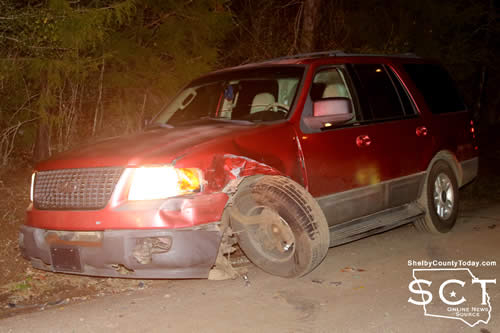
November 29, 2022 - The Texas Department of Public Safety (DPS) Troopers investigated a hit-and-run crash on County Road 2050, near County Road 2020, that occurred Friday, November 25, 2022.
The preliminary investigation indicates that at approximately 9:10 p.m., a 2010 Dodge pickup was traveling east while a 2003 Ford SUV was traveling west. It is reported that the driver of the pickup failed to give one-half of the road and struck the front of the SUV. The pickup fled the scene but was later located, however, the driver remains at large.

The driver of the SUV, identified as Pamela Moody, 36, of Center was transported to Nacogdoches Medical Center for treatment.
If you have any information relating to the driver of the pickup, please contact Lufkin DPS Communications at 936 699 7340.
There is no further information available.

November 29, 2022 - The intersection of State Highway 7 (SH7) East and SL 500 was the scene of a two-vehicle crash November 23, 2022.
According to Center Police Officer Jerry Payne, at 6:34pm a white 2023 Kia K5 driven by Jayden Lotz, 18, with a 17-year-old female passenger was traveling south on SL 500 when he pulled into the right turning lane alongside an 18-wheeler which was stopped at the intersection with SH 7.

Lotz proceeded through the intersection of SH7 and at that time a 2006 grey Dodge Ram pickup truck driven by Trent Wimberly, 19, was eastbound on SH 7 and was subsequently struck on the driver's side by the Kia, causing the truck to roll over.
The Kia came to rest in the middle of the intersection while the truck came to rest on its driver's side in the eastbound lane of SH7.
EMS was on scene and all were examined by them; however, no injuries were reported. No citations were issued at the time of the crash incident.
Assisting at the scene with traffic control were members of the Center Fire Department and Texas Department of Public Safety State Troopers.


November 29, 2022 - A pre-construction meeting was held Monday in the Nacogdoches Area Office, signaling the start of a new construction project in Shelby County.
Crews will set barricades and begin work today on US 96 from 1 mile south of SL 500 to just south of FM 417. The project includes the construction of passing lanes in the 3.4-mile section of roadway. Moore Brothers Construction Co., Lufkin TX, will serve as contractor for the $9.4 million construction project that is scheduled to be completed in September 2023.
This project was designed to enhance safety and mobility on US 96, which is a major thoroughfare and serves as an evacuation route. As this work begins, motorists are urged to obey all traffic control in place, reduce speed near and in the work zone, stay alert for workers and moving equipment near travel lanes and expect delays and/or detours as work progresses.
For more information, contact Rhonda.Oaks@txdot.gov or call (936) 633-4395. For information on road conditions and closures statewide, visit drivetexas.org.

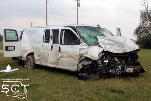
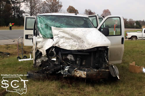
November 29, 2022 - U.S. Highway 84 at the intersection of FM 699 between Tenaha and Joaquin was the scene of a major three-vehicle collision Tuesday, November 29, 2022.
Several individuals involved in the crash were transported from the scene by ambulance for treatment of possible injuries.
Emergency personnel with the Tenaha Volunteer Fire Department and Joaquin Volunteer Fire Department were on scene assisting those involved in the crash while also diverting traffic at the scene.
Texas Department of Public Safety State Troopers are investigating the crash and according to Trooper Ashley White, at 12:45pm a black 2013 Dodge Ram 1500 driven by an unknown male of Nacogdoches disregarded the stop sign on FM 699 traveling south and struck a white 2021 Chevrolet Van driven by Melissa Collins, 47, from Winnie which was westbound on U.S. Highway 84. The Dodge then overturned and collided with a black 2017 Toyota 4Runner driven by Dionne Hankins, 33, from Joaquin.
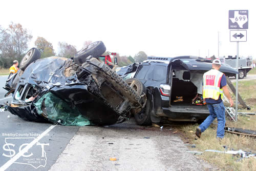
No serious injuries were reported of those involved.
Additional law enforcement personnel at the scene were with the Shelby County Sheriff's Department, Tenaha Police Department, Constable Precinct 4 and Constable Precinct 3.

November 29, 2022 — After a comprehensive process evaluating affiliation with a university system, including responses and feedback from student, faculty, staff and alumni stakeholder groups, as well as the general public, the SFA Board of Regents voted during its special meeting today to accept the invitation of The University of Texas System to become a member institution.
In addition, the board approved a waiver of its rules regarding selection of the next SFA president so the search can begin under the presidential selection rules of the UT System Board of Regents.
SFA regents thanked all participants in the process, as well as the Nacogdoches community, for their work evaluating system affiliation and the proposals of the four systems SFA was invited to join. Their work began Aug. 22 and culminated in reports to the board on Oct. 30.
“We are excited about the enormous opportunities this affiliation will provide for our students, faculty and staff,” said Karen Gantt, SFA Board of Regents chair. “We know that the future of SFA will be enhanced by becoming a member of the leading university system in the country.”
Gantt led the board subcommittee that examined governance, financial and other matters regarding potential affiliation. In addition, she thanked the four systems involved — Texas A&M University System, Texas State University System, Texas Tech University System and The University of Texas System — stating “it has been our honor and privilege to work with these systems and all on their teams and to engage in meaningful and sincere dialogue about opportunities for SFA in their respective university system.”
Kevin P. Eltife, chairman of the UT System Board of Regents, said UT’s regents and leadership deeply admire and respect SFA’s rich tradition and successful history.
“We are honored and enthusiastic about taking the next steps together in this process with confidence that this union will make each of us stronger,” he added. “Our proposal to SFA outlined our sincere commitment to helping the university build upon its programs, traditions and culture that have made the university unique for nearly a century, while adding resources to help amplify those strengths and ultimately serve more Texans.”
With today’s affiliation announcement, the next step is for SFA and UT System officials to collaborate with legislative leaders on the legislation that will enable this governance change during the upcoming session, SFA’s interim President Dr. Steve Westbrook explained.
“In addition, I will be working closely with system officials over the next few weeks as the search for the next SFA president begins, and I will keep the campus updated on that progress,” he added.SFA will retain its name, brand and culture.
For more information, visit sfasu.edu/regents and sfasu.edu/system.
Photos: https://www.dropbox.com/sh/cs5410jszgwdlzd/AAAvH_RXjs4gISKWi8nHKkHka?dl=0
November 28, 2022 - The week of November 20th through 26th, in addition to having the Thanksgiving holiday, yielded 2 calls for the Joaquin Volunteer Fire Department.
Here’s a summary of the weeks events.
The first call came in Sunday afternoon for a mutual aid request from DeSoto Fire District 1 on a brush fire located on Belle Bower Road. The JVFD was en route to the fire when a second page was received that stated the fire was under control and Joaquin could return home.
The other call for the week came in Monday evening for an unresponsive male at his residence on Highway 7 East. The first to arrive on scene reported that the man still had a pulse, but soon after the pulse faded. Allegiance EMS arrived a few minutes later and the man was eventually pronounced deceased. Deputies from Shelby County Sheriff’s Office took control of the scene and the JVFD were cleared to leave.
With that, this report will come to a close. The Joaquin Volunteer Fire Department hopes everyone has a great and safe week ahead.
Pages