

The story headline links to a better view of the story and share features.


News
January 22, 2026 - The March 3rd Primary Election is fast approaching and there are several deadlines to be aware of leading up to Election Day.
Register to Vote
The last day to register to vote is Monday, February 2, 2026. Visit votetexas.gov to register and for more information.
Ballot by Mail
- First day to apply for a ballot by mail using Application for a Ballot by Mail (ABBM) or Federal Postcard Application (FPCA) is Thursday, January 1, 2026.
- Last Day to Apply for Ballot by Mail (Received, not Postmarked) is Friday, February 20, 2026.
- More information about Voting by Mail: https://www.votetexas.gov/voting-by-mail/index.html
- More information and how to file an Application for a Ballot by Mail (ABBM): https://www.votetexas.gov/voting-by-mail/application-for-ballot-by-mail.html
January 31, 2026 - The Red Cross Shelter at First Baptist Church, Center will be closing tomorrow at 12-noon on Sunday, February 1, 2026.
January 27, 2026 - First Baptist Church Center located on Cora Street in the Family Life Center is now an overnight shelter sponsored by the American Red Cross and will potentially be open until Friday. After that the situation will be re-evaluated.
Signage will be located on the street to indicate the shelter.
The shelter will now be open until Friday as a 24-hour overnight location. Anyone seeking shelter may want to bring a pillow and blanket, and there will be cots.
The church is located at 117 Cora Street, and the Family Life Center is behind the church building.
January 30, 2026 - The Shelby County Commissioners met Friday, January 30, 2026, for an emergency meeting to ratify the Declaration of Disaster put in place by Shelby County Judge Allison Harbison on January 23, 2026, in reference to winter storm Fern.
The ratification of disaster reads as follows:
Ratification of Declaration of Disaster
Whereas, the County of Shelby, hereby ratifies the following Declaration of Disaster issued January 23, 2026 for the winter storm designated as 'Fern'.
Whereas, the County of Shelby, on the 23rd of January, 2026, is facing imminent threat of widespread or sever damage, injury, or loss of life or property resulting from severe winter weather. Conditions include below freezing temperatures, ice accumulation on trees, power lines and roadways and possible interruption on utilities.
Whereas, I, Allison Harbison, County Judge of Shelby County, Texas, has determined, based upon trajectory reports issued by the National Weather Service and the Texas State Operations Center, that extraordinary measures must be taken to alleviate the suffering and protect the people of Shelby County, Texas. And to also, protect and/or rehabilitate property; and
Now, Therefore, Be It Proclaimed By The County Judge Of Shelby County, Texas:
I. That a local state of disaster is hereby declared for Shelby County, Texas, pursuant to Section 418.108(a) of the Texas Government Code.
II. Pursuant to Section 418.108(b) of the Texas Government Code, the state of disaster shall continue for a period of not more than seven days from the date of this declaration unless continued or renewed by the Commissioners' Court of Shelby County, Texas.
III. Pursuant to Section 418.108(c) of the Texas Government Code, this declaration of a local disaster shall be given prompt and general publicity and shall be filed promptly with the County Clerk.
IV. Pursuant to Section 418.108(d) of the Texas Government Code, this declaration of a local state of disaster activates the Shelby County, Texas Emergency Management Plan.
This proclamation shall take effect immediately from and after its issuance.
Ordered this 23rd day of January, 2026 and Ratified the 30th day of January, 2026.
Allison Harbison, County Judge Shelby County, Texas

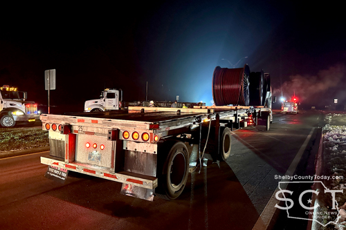
January 29, 2026 - First responders with the Timpson Volunteer Fire Department were dispatched to the location of a two-vehicle crash at the intersection of U.S. Highways 59 and 84 in Timpson on Tuesday, January 27, 2026.
When fire department personnel and Shelby County Sheriff's Department deputies arrived at the scene, they found a truck tractor in the middle of the southbound traffic lane of U.S. 59 and a truck hauling oilfield equipment.
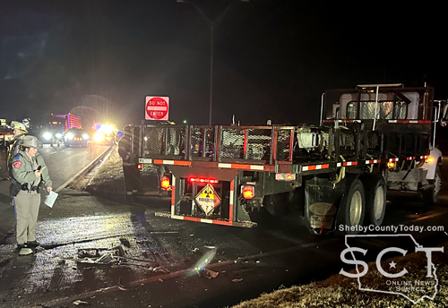
According to details from the Texas Department of Public Safety (DPS), the preliminary crash investigation indicates that at approximately 6:53pm, a white 2012 Peterbilt truck tractor owned by Baker Hughes and driven by Chance King, 28, of Victoria was attempting to cross U.S. 59 to travel east on U.S. 84, while a grey 2020 Peterbilt owned by ZRM Hauling LLC, and driven by Isidro Garcia, 63, of Houston towing a 1993 Raven semi-trailer was traveling south on U.S. 59.
It is reported that the 2012 Peterbilt failed to yield the right-of-way and struck the 2020 Peterbilt.

King and Garcia were reported to not have been injured.
Citation details were not reported.

According to DPS, this is an ongoing investigation, and no further information is available at this time.
Fire personnel and deputies diverted traffic at the location until the crash scene was clear.


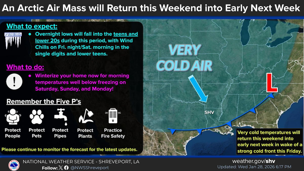
January 29, 2026 - Very cold temperatures will return this upcoming weekend into early next week in wake of a strong cold front on Friday. Wind chills on Friday night / Saturday morning could range from the single digits to lower teens, with morning lows on Saturday, Sunday, and Monday in the teens and lower 20s.
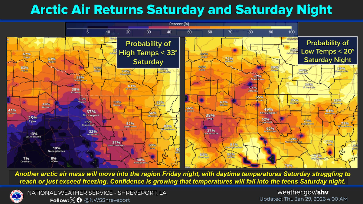
An arctic air mass will result in the return of very cold temperatures Saturday, with readings struggling to reach or exceed the freezing mark during the day. Confidence is high that temperatures will fall into the teens Saturday night.
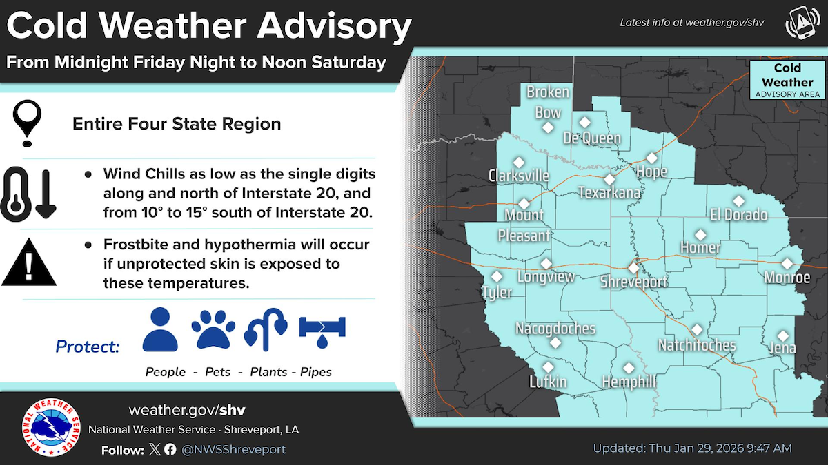
A Cold Weather Advisory is in effect for the entire Four State Region from Midnight Friday through Noon Saturday. Wind chills will range from the single digits north of Interstate 20, to the low to mid teens south of Interstate 20.
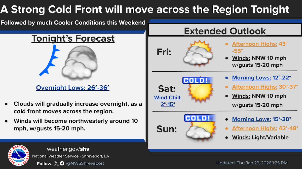
A cold front will move across the Four State Region this evening. Can't rule out an isolated shower across Southern Arkansas and Northern Louisiana along the front. Behind the front, very cold air will move into the region for the upcoming weekend.
Cold Weather Advisory
At 9:05am Thursday, January 29, 2026, the National Weather Service, Shreveport, LA issued a cold weather advisory in effect from midnight Friday night to noon Saturday for Shelby County.
Very cold wind chills as low as the single digits along and north of I-20 and a range of 10 to 15 degrees south of I-20 are expected for portions of south central and southwest Arkansas, north central and northwest Louisiana, southeast Oklahoma, and east and northeast Texas.
Frostbite and hypothermia will occur if unprotected skin is exposed to these temperatures. Wind chill values can lead to hypothermia with prolonged exposure.
Precautionary/Preparedness Actions:
- Use caution while traveling outside. Wear appropriate clothing, a hat, and gloves.
- Keep pets indoors as much as possible.
- Make sure outdoor animals have a warm, dry shelter, food, and unfrozen water.
- Make frequent checks on older family, friends, and neighbors. Ensure portable heaters are used correctly. Do not use generators or grills inside.
January 29, 2026 - Following Winter Storm Fern entering Shelby County on January 22nd, the Texas Division of Emergency Management (TDEM) is encouraging those who may have damage to utilize the TDEM Individual State of Texas Assessment Tool (iSTAT) to submit damages incurred by your Residence or Business property.

The following link and QR code will take you to a page with a link to report damage from the 'January 22 - Winter Weather.' If you need help with how to report, there is an instructional video under the Active Incidents on what procedures to follow in reporting. Individual State of Texas Assesment Tool (iSTAT) Damage Surveys Page
These surveys are available in different languages by clicking on English in the top left corner of the survey.
Also, there is an option for unmet needs which include any debris related needs.
The water on N.E.W. WSC no longer requires boiling.
January 28, 2026 - On January 17, 2026 and January 26, 2026, the Texas Commission on Environmental Quality required the N.E.W. Water Supply, #2030034, to issue a Boil Water Notice to inform customers, individuals or employees that due to conditions which occurred recently in the public water system, the water from this public water system was required to be boiled prior to use for drinking water or human consumption purposes.
N.E.W. Water Supply has taken the necessary corrective actions to restore the quality of the water distributed by this public water system used for drinking water or human consumption purposes. We have also provided TCEQ with laboratory test results that indicate that the water no longer requires boiling prior to use as of January 28, 2026.
If you have questions concerning this matter, you may contact the office: 220 West Columbia Street San Augustine, Texas. 936-288-0489 or Charles Sharp 936-201-5001. Thank you for your patience and cooperation.
January 26, 2026 - Due to electrical issues at the plant, the Texas Commission on Environmental Quality (TCEQ) has required the N.E.W. Water Supply Corporation PWS # 2030034 to notify all customers in Geneva, on Hwy 87, FM 1279, FM 330, Crockett Lane and the East end of FM 353 to boil their water prior to consumption (eg., washing hands/ face, brushing teeth, drinking, etc). Children, seniors and persons with weakened immune systems are particularly vulnerable to harmful bacteria, and all customers should follow these directions.
To ensure destruction of all harmful bacteria and other microbes, water for drinking, cooking and ice making should be boiled and cooled prior to use for drinking water or human consumption purposes. The water should be brought to a vigorous rolling boil and then boiled for two minutes.
In lieu of boiling, individuals may purchase bottled water or obtain water from some other suitable source for drinking water or human consumption purposes.
When it is no longer necessary to boil the water, the public water system officials will notify customers that the water is safe for drinking water or human consumption purposes.
Once the boil water notice is no longer in effect, the public water system will issue a notice to customers that rescinds the boil water notice in a manner similar to this notice.
Please share this information with all the other people who drink this water, especially those who may not have received the notice directly (for example, people in apartments, nursing homes, schools, and businesses). You can do this by posting this notice in a public place or distributing copies by hand or mail.
If you have questions concerning this matter, you may contact N.E.W. Water Supply Corporation at 220 W. Columbia Street, San Augustine, Texas, 75972, or call 936-288-0489 or Charles Sharp at 936-201-5001.
The water on N.E.W. WSC no longer requires boiling.
January 28, 2026 - On January 17, 2026 and January 26, 2026, the Texas Commission on Environmental Quality required the N.E.W. Water Supply, #2030034, to issue a Boil Water Notice to inform customers, individuals or employees that due to conditions which occurred recently in the public water system, the water from this public water system was required to be boiled prior to use for drinking water or human consumption purposes.
N.E.W. Water Supply has taken the necessary corrective actions to restore the quality of the water distributed by this public water system used for drinking water or human consumption purposes. We have also provided TCEQ with laboratory test results that indicate that the water no longer requires boiling prior to use as of January 28, 2026.
If you have questions concerning this matter, you may contact the office: 220 West Columbia Street San Augustine, Texas. 936-288-0489 or Charles Sharp 936-201-5001. Thank you for your patience and cooperation.
January 17, 2026 -Due to electrical issues at the plant, the Texas Commission on Environmental Quality (TCEQ) has required the N.E.W. Water Supply Corporation PWS # 2030034 to notify all customers on FM 711, CR 202, CR 203, CR 205, CR 223, Harmony, Fountain Town, Kellyville and Woodland Acres Communities to boil their water prior to consumption (eg., washing hands/ face, brushing teeth, drinking, etc). Children, seniors and persons with weakened immune systems are particularly vulnerable to harmful bacteria, and all customers should follow these directions.
To ensure destruction of all harmful bacteria and other microbes, water for drinking, cooking and ice making should be boiled and cooled prior to use for drinking water or human consumption purposes. The water should be brought to a vigorous rolling boil and then boiled for two minutes.
In lieu of boiling, individuals may purchase bottled water or obtain water from some other suitable source for drinking water or human consumption purposes.
When it is no longer necessary to boil the water, the public water system officials will notify customers that the water is safe for drinking water or human consumption purposes.
Once the boil water notice is no longer in effect, the public water system will issue a notice to customers that rescinds the boil water notice in a manner similar to this notice.
Please share this information with all the other people who drink this water, especially those who may not have received the notice directly (for example, people in apartments, nursing homes, schools, and businesses). You can do this by posting this notice in a public place or distributing copies by hand or mail.
If you have questions concerning this matter, you may contact N.E.W. Water Supply Corporation at 220 W. Columbia Street, San Augustine, Texas, 75972, or call 936-288-0489 or Charles Sharp at 936-201-5001.
Jamuary 28, 2026 - SET YOUR ALARM CLOCKS!
School in session: Thursday, January 29 Regular bus and bell schedule
PON TU DESPERTADOR!
Clases: Jueves, 29 de enero. Horario habitual de autobuses y timbres.
January 27, 2026 - Due to power outage at the middle school and outages in the surrounding area, Tenaha ISD will remain closed Wednesday, January 28th. Please continue to follow our social media for information on basketball updates/changes.
Tenaha ISD Cerrado El Miércoles 28 De Enero
Debido a un corte de electricidad en la escuela secundaria y a cortes en los alrededores, Tenaha ISD permanecerá cerrado el miércoles 28 de enero. Por favor, sigan nuestras redes sociales para obtener información sobre novedades y cambios relacionados con el baloncesto.
January 28, 2026 - Joaquin ISD classes will resume tomorrow, Thursday, January 29th, beginning at the regular start time of 7:55am.
January 27, 2026 - Joaquin ISD will be closed tomorrow, Wednesday, January 28th due to the winter storm. Stay tuned for updates.
Pages