

The story headline links to a better view of the story and share features.


News
August 1, 2022 - The final week of July closed with three calls for the Joaquin Volunteer Fire Department (JVFD). Here’s a brief rundown of all that occurred.
Starting late in the week with Thursday, July 28th, the JVFD was dispatched to County Road 3267 where a power pole had fallen on a car causing the car catch fire. The incident was discovered to be in the jurisdiction of a neighboring fire department, and therefore the JVFD were called off.
Next in the early morning hours of Saturday, July 30th, the EMR team was dispatched to a residence on Carroll Street for a patient having a high blood sugar attack.
Lastly on Sunday, July 31st, the Joaquin VFD responded to reports of an unresponsive man in his car located in the Subway parking lot. The patient was awake and speaking when Allegiance EMS and a Shelby County Sheriff deputy arrived on the scene.
That concludes the report for this week. Until next time, the Joaquin Volunteer Fire Department hopes everyone has a great and safe week as we begin the month of August.
July 29, 2022 - The Shelby County Sheriff's Department has arrested a former substitute teacher for alleged improper relationship between educator and student, 2nd degree felony.

David Palacios, 22, of Center turned himself in and the Shelby County Jail log indicates he was arrested on July 20, 2022, and was released on the same day on a $5,000 bond set by Justice of the Peace for Precinct 1, Donna Hughes.
According to the arrest affidavit, while Palacios was employed by Center ISD he allegedly had intent to commit indecency with a child by communicating through electronic mail or text message such as Instagram or cellular phone text messages in a sexually explicit manner with a person who was enrolled in Center High School.
Shelby County Sheriff's Investigator David Haley determined Palacios was a substitute teacher at Center ISD from October 2020 until March 2021 and Investigator Haley learned that Palacios allegedly had inappropriate relationships with several female students, including physical contact, throughout his time as a substitute teacher.
July 27, 2022 - The Tenaha City Council met Monday, June 25, 2022, in a regular meeting as they continued to discuss several items previously considered.
The meeting is viewable on Shelby County Today via this article, and just previous to the start of the first video of three the council approved the minutes of the May meeting with all members in favor.
The meeting minutes from June 2022 were also approved; however, with three council members in favor of the approval and two against.
An item which appears may have a negative financial impact on the city was brought to light by a letter from the Texas Comptroller indicating the city owes $73,000 to the comptroller as the result of a business not in the city limits charging sales tax to its customers as though it were a business in the city limits.
Agenda for the meeting can be viewed by clicking here.
The video of the meeting was split into sections. View the following videos to watch the meeting following the approval of minutes from the May and June meetings:
Tenaha City Council July 25, 2022 - Video 1 of 3
Tenaha City Council July 25, 2022 - Video 2 of 3
Tenaha City Council July 25, 2022 - Video 3 of 3
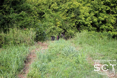
July 27, 2022 - State Highway 87 North near County Road 4009 was the scene of a single-vehicle crash Tuesday, July 26, 2022.
Units with the Texas Department of Public Safety (DPS) and Texas Game Wardens responded to the crash following reports the driver involved was trapped inside a vehicle which had rolled over.
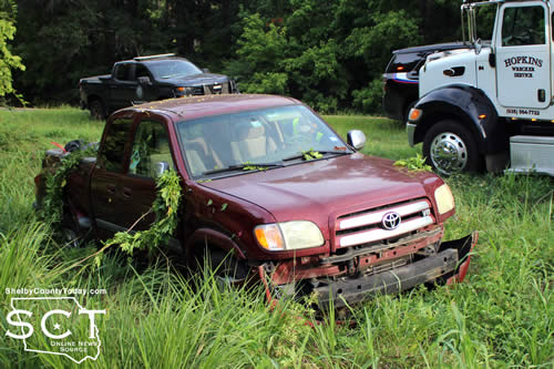
According to Texas DPS Trooper Dustin Ramos a maroon 2004 Toyota Tundra driven by Vivi Harlan, 36, of Timpson was southbound on State Highway 87 when Harlan went to pass another vehicle on the right when the road went to three lanes and failed to drive in a single lane. The vehicle was over corrected to the left and traveled off the roadway where it rolled over onto its right side.
No injuries were reported as a result of the crash and Harlan was issued a citation for fail to maintain a single lane.
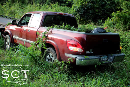
Texas Game Warden Sam Anderson (BSM) assisted at the scene along with Shelby County Sheriff's Deputies Jake Gross and Jordan Ford.

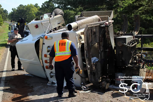
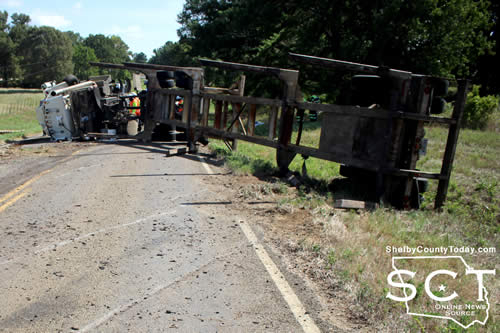
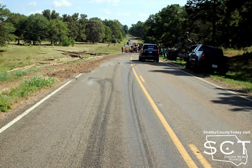
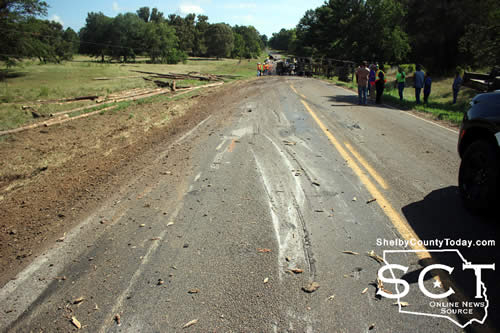
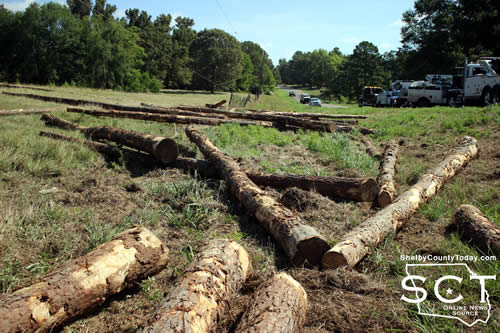
July 27, 2022 - FM 1645 in the Huber community was the location of a single-vehicle crash involving a truck-tractor hauling a load of logs on Monday, July 25, 2022, at around 8:30am.
When emergency responders arrived at the crash scene around a half mile from State Highway 87 North the truck-tractor, owned by 4D Farms, was on its side across both lanes of FM 1645 and the contents of its trailer was spilled along the side of the road and through a fence along a nearby field.
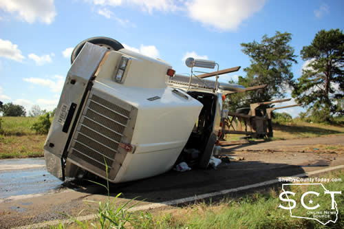
The crash had occurred immediately following a curve in the roadway. At the time the crash occured, the Texas Department of Public Safety was already investigating another crash in San Augustine County and the Shelby County Sheriff's Department (SCSD) assisted by handling the investigation on FM 1645.
According to Shelby County Sheriff's Deputy Jake Gross, a white 2011 Kenworth hauling a load of trees driven by Bunkcome Williams of Center was northbound on FM 1645 when he failed to control speed and the truck-tractor rolled over, losing its load and coming to rest in the middle of the road.
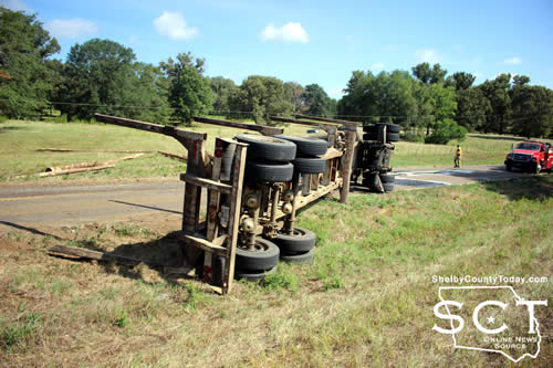
No injuries were reported as a result of the crash and no citations were issued.
Center Fire Department personnel responded to the incident and assisted with traffic control until the scene was clear.
Deep East Texas Electric Cooperative utility crews worked to repair power lines and a utility pole which was broken. A TxDOT crew was also on scene to assist.
July 26, 2022 - The water on Denning Rural WSC no longer requires boiling.
On July 21, 2022, the Texas Commission on Environmental Quality required the Denning Rural Water Supply, #2030004, to issue a Boil Water Notice to inform customers, individuals or employees that due to conditions which occurred recently in the public water system, the water from this public water system was required to be boiled prior to use for drinking water or human consumption purposes.
Denning Rural Water Supply has taken the necessary corrective actions to restore the quality of the water distributed by this public water system used for drinking water or human consumption purposes and has provided TCEQ with laboratory test results that indicate that the water no longer requires boiling prior to use as of July 26, 2022.
If you have questions concerning this matter, you may contact the office:
220 West Columbia Street
San Augustine, Texas.
936-288-0489
or
Charles Sharp 936-201-5001.
Thank you for your patience and cooperation.
If a customer, individual or employee wishes to contact the executive director, please call (512)239-4691.
July 21, 2022 - Due to a loss of pressure at the Plant, the Texas Commission on Environmental Quality (TCEQ) has required the Denning Rural Water System PWS # 2030004 to notify ALL customers to boil their water prior to consumption (eg., washing hands/ face, brushing teeth, drinking, etc). Children, seniors and persons with weakened immune systems are particularly vulnerable to harmful bacteria, and all customers should follow these directions.
To ensure destruction of all harmful bacteria and other microbes, water for drinking, cooking and ice making should be boiled and cooled prior to use for drinking water or human consumption purposes. The water should be brought to a vigorous rolling boil and then boiled for two minutes.
In lieu of boiling, individuals may purchase bottled water or obtain water from some other suitable source for drinking water or human consumption purposes.
When it is no longer necessary to boil the water, the public water system officials will notify customers that the water is safe for drinking water or human consumption purposes.
Once the boil water notice is no longer in effect, the public water system will issue a notice to customer that rescinds the boil water notice in a manner similar to this notice.
Please share this information with all the other people who drink this water, especially those who may not have received the notice directly (for example, people in apartments, nursing homes, schools, and businesses). You can do this by posting this notice in a public place or distributing copies by hand or mail.
If you have questions concerning this matter, you may contact Denning Rural Water System at 220 W. Columbia Street, San Augustine, Texas, 75972, or call 936-288-0489 or Charles Sharp at 936-201-5001.
July 25, 2022 - The week of July 18 through July 24 yielded one call for the Joaquin Volunteer Fire Department (JVFD). That’s quite the opposite from last weeks high call volume.
Wednesday, July 20 at 9:07pm the Joaquin VFD was dispatched to a medical emergency on Cummings Street. Members of the EMR (Emergency Medical Response) team arrived to find a male patient that was disoriented and having trouble walking. The EMRs checked the patient's vitals while waiting on Allegiance EMS to arrive to transport the patient.
In other news, three members of the JVFD will be in College Station, Texas over the next few days at the TEEX Municipal Fire School. The Joaquin VFD sends members to this Fire School annually, as it is held, to learn techniques that will help us better serve the community. In addition, certain members of our department have the privilege of educating firefighters from all across Texas as instructors. Training Officer Stephen Ewing will be instructing a class on Internal Structural Firefighting, Assistant Chief Rusty Wilson will be taking a Fire Officer 2 class, and Firefighter Michael Bates will be taking a class on Vehicle Extrication. We wish them good luck and safe travels.
That will conclude the report for the week, so until next time we hope everyone has a great and safe week ahead.
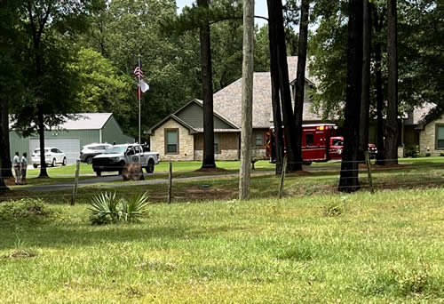
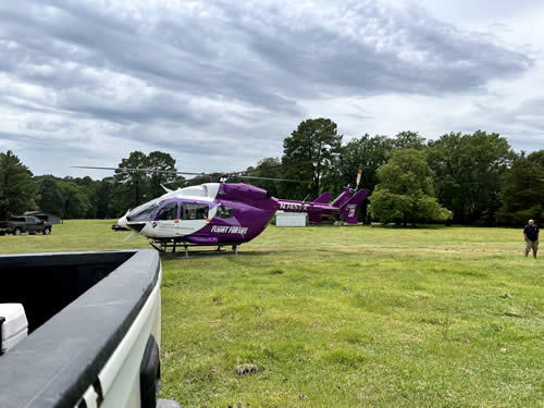
July 22, 2022 - While on a call around approximately 1:40 pm the Timpson Volunteer Fire Department (TVFD) received another call to assist Allegiance EMS with a landing zone.
Multiple other units responded and upon arrival fire personnel along with Shelby County Constables began to set up the landing zone in a field across the road from the residence that was more open.
Once the patient was loaded onto the Life Flight and the helicopter cleared the scene fire personnel cleared and returned to the station.
Timpson Volunteer Fire Department continues to accept applications for new members seeking to join the department and help your community.
TVFD can also be located on facebook by clicking this link.


July 22, 2022 - On 07/20/2022, the Texas Commission on Environmental Quality required the Choice public water system, 2100005 to issue a Boil Water Notice to inform customers, individuals, or employees that due to conditions which occurred recently in the public water system, the water from this public water system was required to be boiled prior to use for drinking water or human consumption purposes.
The public water system has taken the necessary corrective actions to restore the quality of the water distributed by this public water system used for drinking water or human consumption purposes and has provided TCEQ with laboratory test results that indicate that the water no longer requires boiling prior to use as of 07/22/2022.
If you have questions concerning this matter, you may contact, Matt Di Verdi 936-591-4346.
July 20, 2022 - Due to a broken water main the Texas Commission on Environmental Quality has required the Choice Water system, ID# 2100005 to notify customers that were without water 07/20/2022 on FM 2140 (anyone without water) to boil their water, prior to consumption (e.g., washing hands/face, brushing teeth, drinking, etc). Children, seniors, and persons with weakened immune systems are particularly vulnerable to harmful bacteria, and all customers should follow these directions.
To ensure destruction of all harmful bacteria and other microbes, water for drinking, cooking, and ice making should be boiled and cooled prior to use for drinking water or human consumption purposes. The water should be brought to a vigorous rolling boil and then boiled for two minutes.
In lieu of boiling, individuals may purchase bottled water or obtain water from some other suitable source for drinking water or human consumption purposes.
When it is no longer necessary to boil the water, the public water system officials will notify customers that the water is safe for drinking water or human consumption purposes.
Once the boil water notice is no longer in effect, the public water system will issue a notice to customers that rescinds the boil water notice in a manner similar to this notice.
Please share this information with all the other people who drink this water, especially those who may not have received this notice directly (for example, people in apartments, nursing homes, schools, and businesses). You can do this by posting this notice in a public place or distributing copies by hand or mail.
If you have questions concerning this matter, you may contact Matt Di Verdi 936-591-4346

July 21, 2022 - State Highway 7 West was the scene of a two-vehicle crash on July 15, 2022, just under seven miles from Center in the Mt. Herman community.
Accoring to Texas Department of Public Safety State Trooper Keith Jones, upon arrival just after 2:51pm the roadway was blocked by two passenger vehicles involved in the crash. During investigation it was determined a grey 2010 Ford Edge driven by Angela Escobedo, 24, of Tenaha exited a private driveway onto State Highway 7 West preparing to turn west.
The Edge failed to yield right of way to a white 2021 Lincoln Corsair driven by Saundra O'Connor, 60, of Center traveling eastbound which then struck the Edge on the driver's side, causing major damage to both vehicles.

Escobedo and her passenger Eulalia Guadalupe-Solis, 54, were transported by ambulance to Nacogdoches Medical Center for treatment. O'Connor was transported by private vehicle to Shreveport for treatment of her injuries.
A 4-year-old minor female passenger in the Edge was not injured and was tranported from the scene by a family member.
Escobedo was issued a citation for fail to yield right of way private drive.
West Shelby County Volunteer Fire Department and Shelby County Sheriff's Deputies assisted in directing traffic past the crash scene.

Pages