

The story headline links to a better view of the story and share features.


News
September 8, 2021 - According to the Texas DSHS Covid-19 Dashboard, there were 29 new cases and 4 recoveries reported today. The number of active cases increased to 212.
Yesterday, the dashboard reported 19 new cases.
September 8th Numbers: (changes since Sept. 7)
Confirmed Cases - 1,507 (5 new)
Probable Cases - 1,033 (24 new)
Fatalities - 80
Active Cases (Estimated) - 212
Recovered (Estimated) - 2,248 (4 new)
September 7th Numbers: (changes since Sept. 6)
Confirmed Cases - 1,502 (10 new)
Probable Cases - 1,019 (9 new)
Fatalities - 80
Active Cases (Estimated) - 187
Recovered (Estimated) - 2,244 (14 new)
September 6th Numbers: (changes since Sept. 5)
Confirmed Cases - 1,492 (3 new)
Probable Cases - 1,000
Fatalities - 80
Active Cases (Estimated) - 182
Recovered (Estimated) - 2,230 (15 new)
September 8, 2021 - Tri-County Community Action, Inc. will hold a monthly Board Meeting along with a Public Hearing on Monday September 13, 2021 Via Zoom conference call at 6:30pm.
For more information please call Yolanda Neal (936) 598-6315 ext; 200
September 8, 2021 - In the United States, Patriot Day occurs on September 11 of each year in memory of those killed that day in 2001. US Flags and other flags flying with it should be lowered to half staff at sunup on Saturday, September 11, 2021 and raised at sundown the same day. It is permissible to lower them the evening before on September 10.
If you have outdoor flags that cannot be lowered, respect for the day can be shown by tying a black cord or ribbon to the top of the mast.
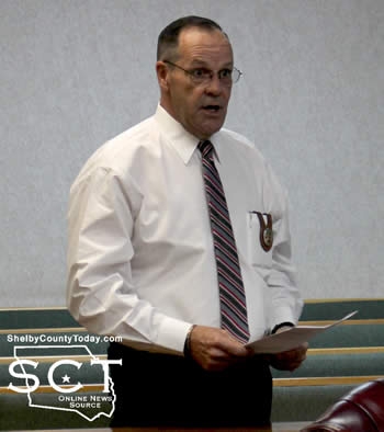
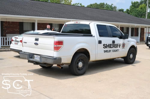
September 7, 2021 - The Shelby County Commissioners approved the receipt of a donation of two storage buildings during their meeting September 1, 2021, for radio antenna equipment.
"This is for the two new microwaves that are going in in Tenaha and Shelbyville," said County Judge Allison Harbison. "The Sheriff's Office, I had called and got a quote for buildings, but they went above and beyond and got a donation of two buildings."
Judge Harbison explained each of the buildings is valued at $6,500 bringing the total of the in kind donation to $13,000 from Spartan Structures.
"These buildings needed to be insulated and be equipped with electrical," said Sheriff Kevin Windham.
As a result, Sheriff Windham explained the buildings will be insulated and electrically wired for their purposes.
"Lieutenant [Tanner] Peace, he reached out to Spartan and they were generous and kind enough to offer us these two buildings at no charge," said Sheriff Windham. "We're going to need it pretty quick, so they said they would get right on 'em."
Sheriff Windham said, on behalf of the Shelby County Sheriff's Department and the residents of Shelby County, "We would appreciate the Commissioners' Court accepting this generous donation of these two buildings for our radio system, because that's what's going to be equipped in there."
The dimensions of the buildings are 8' x 10' and they will have heating and cooling.
A motion carried by the commissioners to approve the donation of the two buildings with a value of $13,000.
At a previous meeting, Sheriff Windham presented a proposal for cameras to be installed in the Sheriff's Department patrol vehicles; however, the cost was at a point where bids would be required.
"You (Sheriff Windham) have gone back to the company, Watchguard, and they gave us a further discount, [total] of $49,440," said Judge Harbison.
This made the amount one the commissioners could consider without needing to seek bids from different companies.
Eight units are proposed with vehicle cameras and body cameras included.
"Each of these new units will be installed in our eight patrol units, we do have a couple cameras that are still functional," said Sheriff Windham. "I think we have three, and those units, their cameras will be taken out and they will be put into our transport vehicles and then also in our trusty vehicles."
Sheriff Windham clarified, vehicles which are used to transport trustys.
A motion carried to approve the purchase of the camera systems at a rate of $49,440 to be sourced from the Covid fund.
A motion carried to adjourn the meeting.
Agenda items approved during the meeting include:
1. Pay weekly expenses.
2. Current payroll.
3. Donation for two portable buildings for the antenna equipment.
4. Purchase cameras for the inside of Sheriff's Department patrol vehicles.
5. Adjourn.
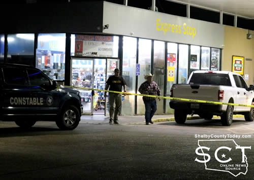
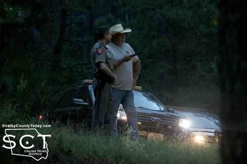
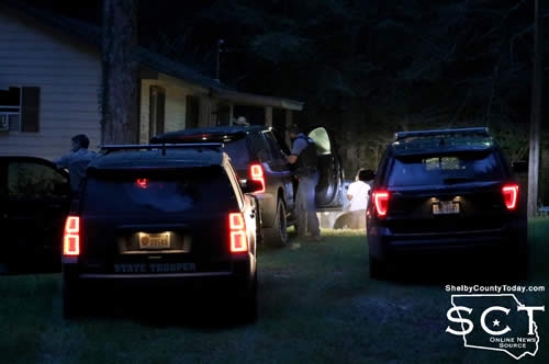
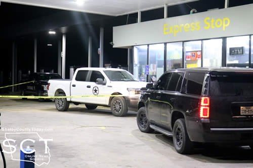
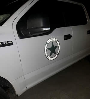
September 7, 2021 - Shelby County Constables have taken action to halt an alleged illegal gambling operation Sunday, September 5, 2021, which was ongoing in the northern part of the county.
A total of 16 gambling machines and a large sum of money were taken into evidence by the officials.
The constables were joined by other law enforcement officers to simultaneously serve warrants at two locations, in Precinct 3 and Precinct 4, believed to be connected in the illegal operation of gambling venues.
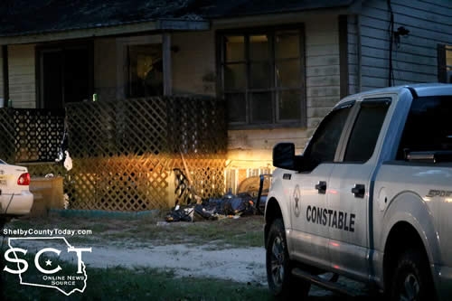
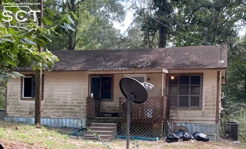
At around 7:30pm, law enforcement officials moved in on Express Stop fuel station/Valero located on North George Bowers Drive in Tenaha and a house located on the 100 block of CR 3533.
Both locations were moved on without incident, and while officers held the scene outside the house, other officers were interviewing people inside and inventorying its contents.
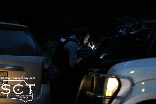
According to Josh Tipton, Constable Precinct 5, and Roy Cheatwood, Constable Precinct 3, the investigation into illegal gambling in Precinct 3 began around two months ago and through that investigation led the officers to the fuel station in Tenaha.
As the investigation continued to develop, the officers obtained information of illegal gambling and promotion of illegal electronic gaming devices.
According to the constables, for those playing games, instead of receiving a prize of not more than 10 times the amount charges to play the game or device or $5, whichever is less, as stated in Chapter 47 of the Penal Code relating to gaming, they were receiving cash as someone would in a casino. The constables stated, according to the Penal Code, that is illegal. (Read the statute by clicking here)
Through the use of probable cause and video evidence, the officers sought warrants, signed by a District Judge, and served those warrants on the store and the house. According to the constables, the same individual that owns the fuel station, also owns the house.
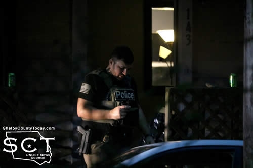
Constables Tipton and Cheatwood stated, further seizures may be sought as a result of their investigation, and a substantial amount of undisclosed cash has been discovered, which along with documentation, and electronic devices has been seized and taken to a secure location.
The constables stated their greatest concern involving both locations was the possibility of eventual armed robbery or homicide resulting from the illegal activities and the public knowledge of large sums of money being at those locations.
Reports have been received by the constables from family members of people gambling at the machines with "money they don't have," and the constables said they felt it their obligation and duty to shut down the operation.
No arrests have been made at this time.
The constables expressed appreciation to the Texas Department of Public Safety; Taylor Fanguy, Constable Precinct 4; Jamie Hagler, Constable Precinct 2; Scott Burkhalter, Tenaha Police Chief; and Billy Lusk, Timpson ISD Police.
They also thanked the citizens of their precincts, because without their help they couldn't have made the operation happen.
Special thanks was given to Dondi Tipton for getting up in the middle of the night to help haul the gaming machines to a secure location with his truck and trailer.
September 6, 2021 - According to the Texas DSHS Covid-19 Dashboard, there has been 18 new cases and 14 recoveries reported since Saturday, September 4th. The number of active cases decrease to 182.
September 6th Numbers: (changes since Sept. 5)
Confirmed Cases - 1,492 (3 new)
Probable Cases - 1,000
Fatalities - 80
Active Cases (Estimated) - 182
Recovered (Estimated) - 2,230 (15 new)
September 5th Numbers: (changes since Sept. 4)
Confirmed Cases - 1,489 (9 new)
Probable Cases - 1,000 (6 new)
Fatalities - 80
Active Cases (Estimated) - 194
Recovered (Estimated) - 2,215 (8 new)
September 4th Numbers: (changes since Sept. 3)
Confirmed Cases - 1,480 (12 new)
Probable Cases - 994 (2 new)
Fatalities - 80
Active Cases (Estimated) - 187
Recovered (Estimated) - 2,207 (14 new)
September 4, 2021 - According to the Texas DSHS Covid-19 Dashboard, 14 new cases and 14 recoveries were reported today. The number of active cases remains at 187.
September 4th Numbers: (changes since Sept. 3)
Confirmed Cases - 1,480 (12 new)
Probable Cases - 994 (2 new)
Fatalities - 80
Active Cases (Estimated) - 187
Recovered (Estimated) - 2,207 (14 new)
September 3rd Numbers: (changes since Sept. 2)
Confirmed Cases - 1,468 (20 new)
Probable Cases - 992 (5 new)
Fatalities - 80
Active Cases (Estimated) - 187
Recovered (Estimated) - 2,193 (13 new)
September 3, 2021 - According to the Texas DSHS Covid-19 Dashboard, 25 new cases and 13 recoveries were reported today. The number of active cases increased to 187.
September 3rd Numbers: (changes since Sept. 2)
Confirmed Cases - 1,468 (20 new)
Probable Cases - 992 (5 new)
Fatalities - 80
Active Cases (Estimated) - 187
Recovered (Estimated) - 2,193 (13 new)
September 2nd Numbers: (changes since Sept. 1)
Confirmed Cases - 1,448 (7 new)
Probable Cases - 987 (5 new)
Fatalities - 80 (3 new)
Active Cases (Estimated) - 178
Recovered (Estimated) - 2,180 (17 new)
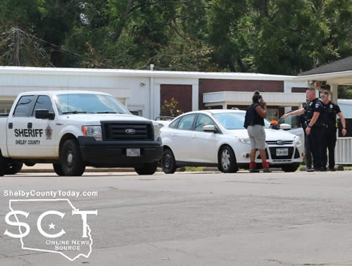
September 3, 2021 - Center Police Officers investigated a two-vehicle crash at the intersection of Tenaha and Foster Streets on Thursday, September 2, 2021.
According to Center Police Officer Brian Wright, a Shelby County Sheriff's patrol vehicle 2010 Ford F-150 driven by Shelby County Sheriff's Investigator David Hailey, 48, of Center was northbound on Tenaha Street when he stopped to give right of way to a vehicle turning in front of him.
At that time a white 2012 Ford Focus driven by Lillian Sharp, 18, of San Augustine was also northbound on Tenaha Street and failed to control speed, striking the pickup truck in the rear.
Both vehicles received minimal damage, and were able to safely move out of the roadway to a nearby parking lot. No injuries were reported.
The Ford Focus was towed from the scene and Sharp was issued a citation for no insurance.
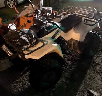
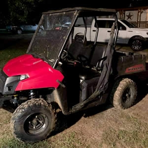
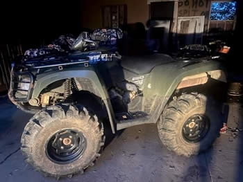
September 2, 2021 - Northern Shelby County Constables Josh Tipton, Precinct 5, and Roy Cheatwood, Precinct 3, report the recovery of several ATV and UTV units in the Timpson area.
Constable Cheatwood took a report of a stolen ATV in the Sardis community Sunday, August 29, 2021.
Through investigation with Constable Tipton the constables learned where the stolen ATV and a UTV were possibly located.
As a result of the constables efforts, they were successful in locating and recovering two four-wheelers and a Polaris side-by-side vehicle in the Timpson area on September 1.
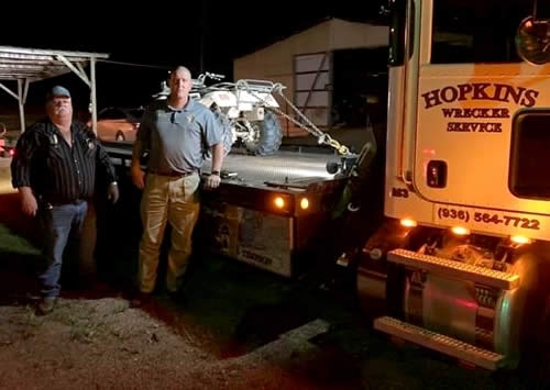
Hopkins Wrecker service was called to the scene to recover and haul the vehicles away.
The investigation remains ongoing and more details will be released at a later date.
Pages