

The story headline links to a better view of the story and share features.


News
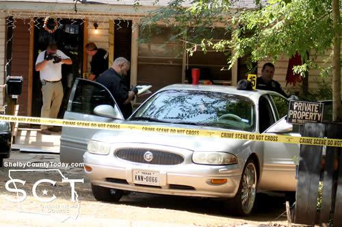
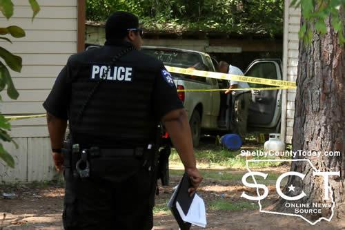
July 5, 2018 - Sampson Street in Center was the scene of an incident Thursday, July 5, 2018 in which a man was reported to be unresponsive in a back yard.
Center Police Department officers were dispatched to the scene, as well as ambulance personnel at around 10:30am. When Shelby Country Today arrived at the location, officers had cordoned off the outside of the residence and the street.
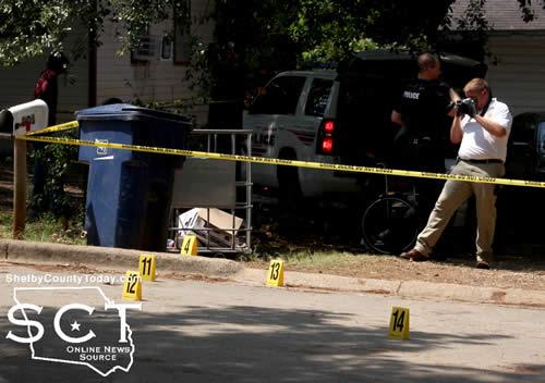
Residents in the neighborhood surrounded the area and it appeared officers were investigating a possible homicide in the back yard of the residence and seemed to be focused on an area at the front of a pickup truck, which was facing away from the house.
According to a press release issued Friday, July 6, 2018 by Center Police Department Sgt. Nicole Faulkner, at approximately 10:23am July 5, Center Police Department responded to a call of an unresponsive person on Sampson St. Upon arrival, officers found Brakia Rashad Roland, 27, of Center deceased.
Mike Crouch, Justice of the Peace Precinct 5, conducted the inquest and an autopsy has been ordered. Community Funeral Home transported Roland from the scene and he was taken to a facility in Tyler for an autopsy.
The press release finished by indicating the case has been ruled a homicide.

6:46am CDT Tuesday, July 3, 2018
July 3, 2018 - The National Weather Service has issued a Hazardous Weather Outlook for southern Arkansas, for northern Louisiana, for eastern Texas and southeast Oklahoma including Sevier, Howard, Little River, Hempstead, Nevada, Miller, Lafayette, Columbia, Union, Caddo, Bossier, Webster, Claiborne, Lincoln, De Soto, Red River, Bienville, Jackson, Ouachita, Sabine, Natchitoches, Winn, Grant, Caldwell, La Salle, McCurtain, Bowie, Franklin, Titus, Camp, Morris, Cass, Wood, Upshur, Marion, Smith, Gregg, Harrison, Cherokee, Rusk, Panola, Nacogdoches, Shelby, Angelina, and San Augustine.
Today and Tonight... Scattered showers and thunderstorms will be possible today across the region as an Easterly wave of tropical moisture moves Westward along the Gulf coast. Any thunderstorms could produce dangerous lightning and gusty winds near heavy downpours. Isolated severe activity may be possible during the mid to late day heat and could bring down damaging winds. Otherwise, the heat will continue in the middle to upper 90s in eastern Texas, southeast Oklahoma and adjacent southwest Arkansas. This above average heat along with the humidity will push the heat index values from 100 to 105 degrees. If you must be outside, remember to take frequent shade
breaks and drink plenty of water.
Wednesday through Monday... Coverage of thunderstorms will remain scattered south of I-20 while becoming more isolated for areas north of I-20 on the Fourth of July. However, the coverage will increase for northern areas and linger over the south as a slow moving cold front approaches the region. The main threat from any strong thunderstorms in this heat will be for some damaging winds and dangerous lightning into next week. If thunder roars, move indoors.
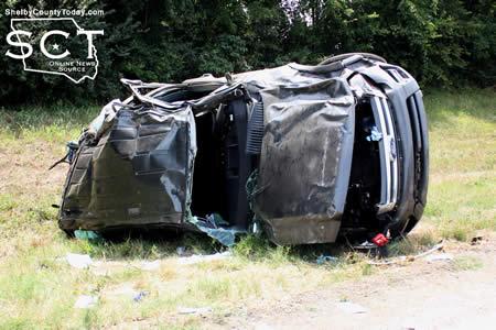
July 3, 2018 - U.S. Highway 96, just south of Fork Creek was the scene of a major two-vehicle crash Tuesday, July 3, 2018.
According to Texas Department of Public Safety State Trooper Taylor Buster, at 11:30am a tan 2008 Jeep Cherokee driven by Lynda Huebel, 72, of Shelbyville was southbound on U.S. 96 when she fell asleep at the wheel.
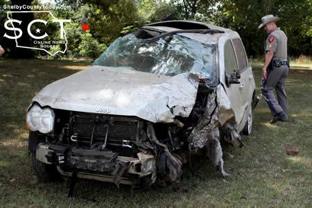
The Jeep traveled into the northbound lanes and struck the rear of a grey 2015 Ford Expedition driven by Sharon Ray, 45, of Hemphill. Both vehicles flipped several times before coming to a stop on the eastern side of the roadway.
Ray was transported by ACE EMS to Nacogdoches Medical Center - Shelby Emergency Department for treatment of her injuries.

No citations were issued at the time of the crash.
The Center Fire Department and Shelby County Sheriff's Department deputies assisted at the scene with traffic control.


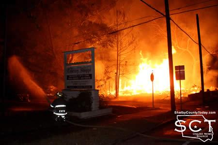
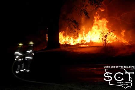
July 3, 2018 - The morning sky was aglow with flames at the intersection of Center and Shelbyville streets early Tuesday, July 3, 2018 in Center due to a house fire.
When Center Fire Department firemen arrived at the McLendon house, not long after 5am, the two-story structure was completely engulfed in flames. Embers were escaping into the still dark sky as flames also found their way across Shelbyville Street to neighboring yards where residents were wetting roofs with garden hoses to prevent fire from catching.
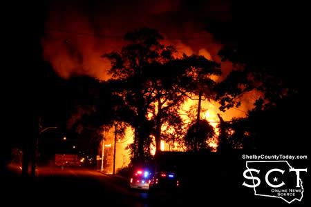
Water was applied by firemen to structures located directly next door to the enflamed building in attempts to prevent further spread of the fire.
Police officers encouraged one resident two doors down from the flaming building to at least be prepared to evacuate his home in case the fire reached his residence, however it did not.

The wooden house burned hot and fast until what remained was a single flame, emanating out of what used to be the back of the house, from an old natural gas line.
Shelbyville Street was shut down from Pine Street to Center Street by Center Police Department and Center Fire Department until the firemen cleared the scene.
Public records indicate the home is owned by Clifton McLendon. The property was not being lived in at the time of the fire.


July 3, 2018 - The Shelby County Appraisal District does not have phone service at this time. It is unknown when our phones will be working again. We believe the lines were damaged from a house fire on Shelbyville street.

July 2, 2018 - The Shelby County Sheriff’s Office is actively investigating a report of criminal mischief that occurred between the evening hours on June 29 and early morning hours on June 30, 2018 at the Smith Cemetery on CR 3153 in Center.
Suspects appeared to have connected part of the fencing to a vehicle and peeled approximately 150 feet of fence from its setting. The damage occurred on both sides of the roadway. A total of 300 feet of fencing was damaged. The cemetery gate was also ripped from the fence.
The initial investigation revealed the tire tracks were from a dually type of vehicle.
If you have any information regarding this case, you are asked to contact the Shelby County Sheriff’s Office at 936.598.5601.
July 2, 2018 - The National Weather Service Shreveport, LA issues a Hazardous Weather Outlook at 10:37am CDT Monday, July 2, 2018.
This Hazardous Weather Outlook is for portions of northwest Louisiana, east Texas and northeast Texas - De Soto, Sabine, Wood, Upshur, Marion, Smith, Gregg, Harrison, Cherokee, Rusk, Panola, Nacogdoches, Shelby, Angelina, San Augustine
Today and Tonight... An upper level ridge of high pressure will remain anchored over much of the area today. As a result, temperatures will climb into the upper 90s to near 100 degrees this afternoon. When combined with the humidity, heat indices will range from 100 to 105 degrees once again. If you must be outside, remember to take frequent breaks and drink plenty of water.
Tuesday through Sunday... An upper level disturbance will drift west across the Lower Mississippi Valley and into Southern Arkansas and much of Louisiana Tuesday, which should help initiate scattered to numerous showers and thunderstorms over much of the region. However, one more day of very hot temperatures is expected especially over East Texas, Southeast Oklahoma, portions of Southwest Arkansas and Northwest Louisiana, as temperatures again climb into the upper 90s, and resultant heat indices range between 100 and 105 degrees. These scattered showers and thunderstorms will persist Tuesday night and Wednesday over much of the region as this disturbance continues to drift west across the area. Brief heavy rainfall and locally gusty winds will be possible in the stronger storms. While these storms may become more isolated Thursday, scattered showers and thunderstorms should increase Friday through Sunday, ahead of a potential series of upper level disturbances that will again shift west across the region.
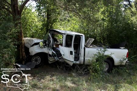
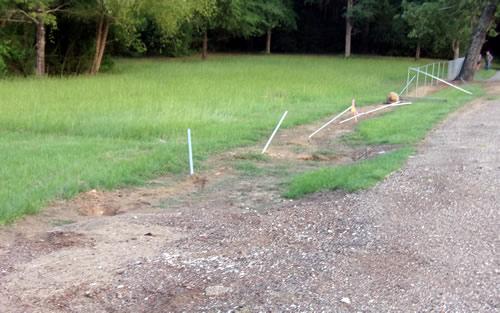
June 29, 2018 - State Highway 7 West was the scene of a major single-vehicle crash from which the driver was flown by ambulatory helicopter Thursday, June 28, 2018.
The crash was witnessed by John Green, who was preparing to enter SH7 from CR 1211 (Lake Pinkston Road) when he witnessed the truck leave the roadway following which he called for emergency assistance.
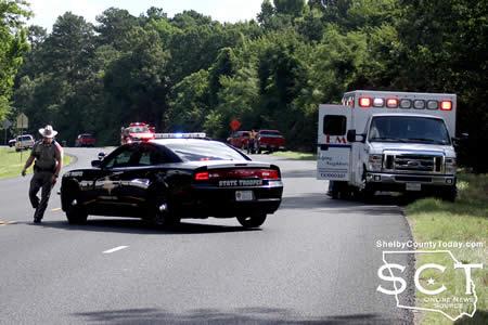
While Texas Department of Public Safety State (DPS) Troopers arrived and began investigating the incident, members of the West Shelby County Volunteer Fire Department and Shelby County Sheriff's Deputies assisted with traffic control.
The driver of the pickup truck was moved from her vehicle by ACE EMS personnel, who were assisted by DPS Troopers and firemen in getting her to an ambulance. Center Fire Department firemen and Center Police Officers were also on scene to help.
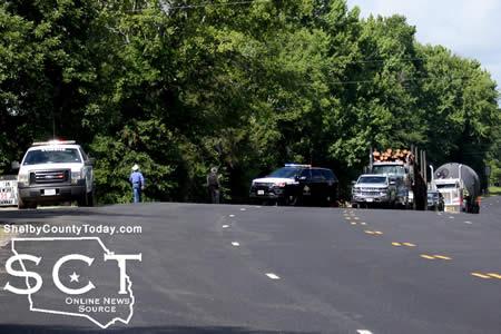
It was determined a helicopter was needed to transport the driver and a landing zone was established in the middle of SH 7.
According to Texas DPS State Trooper Jesse Fountain, at 9:20am white 1999 Ford F-250 driven by Elaine Higginbotham, 76, of Center was eastbound on SH 7. At that time she failed to negotiate a left-hand curve in the roadway and left the pavement before striking several trees.
When emergency personnel arrived on scene, Higginbotham was trapped within the truck and it took several men and fire personnel to get her out of the vehicle.
Higginbotham was transported from the scene by Life Air Rescue to University Health in Shreveport for treatment of unknown injuries.


 Traffic Alert - Road Closure
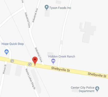
June 28, 2018 - State Highway 87 / Shelbyville Street in Center will be closed on Friday, June 29th at the BNSF Railroad crossing for work that is being done by the railroad.
RoadSafe Traffic Systems will have the BNSF railroad crossing on Shelbyville St near the Tyson Foods plant closed 7:30am to 4:00pm so BNSF can make needed repairs to the crossing at this location. We will have a detour route in place please follow and pay attention to the construction signs that will be place out.
June 28, 2018 - Center PD Traffic Stop Leads to Discovery of Cocaine

Center Police Officer Brian Wright conducted a traffic stop on a vehicle being driven by Marcus Brandon Cartwright on June 23, 2018. During the traffic stop Center Police Department (CPD) Sgt. Knowlton utilized his canine, K9 Elliott, who then alerted on the vehicle.
A search of the vehicle resulted in Officers recovering approximately .5 grams of suspected cocaine.
Cartwright is currently out on parole for a previous narcotics related arrest. Cartwright was subsequently arrested for Possession of a Controlled Substance PG1<1G.
PCP, Drug Paraphernalia Leads to Narcotics Seizure, Arrest of Two


CPD Sergeant Christopher Knowlton conducted a traffic stop on a vehicle being driven by Shamus Jaquan Ross. During the traffic stop a probable cause search was conducted of the vehicle with the discovery of approximately 13.5 grams of suspected Phencyclidine (PCP) being made.
Ross was subsequently arrested for the recovered PCP and his passenger, Eric Jerome Nobles, was arrested for a “crack” pipe that was recovered from his pants pocket.
Methemphetamine Discoverd During CPD Traffic Stop
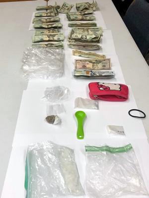
 Officer Brian Wright conducted a traffic stop on a vehicle being driven by Juanita Lee Briggs on June 10, 2018. During the traffic stop Sgt. Knowlton utilized his canine, K9 Elliott, who then alerted on the vehicle. A search of the vehicle and Briggs’ person was then conducted with officers recovering approximately 34 grams of suspected methamphetamine, multiple baggies for narcotics packaging, and a set of digital scales.
A warrant has been issued for Briggs’ arrest for the recovered narcotics.
Pages