

The story headline links to a better view of the story and share features.


News
February 22, 2018 - The following criminal defendants failed to appear for a pre-trial hearing in the 123rd Judicial Court, Shelby County, Texas:
Wesley Dewitt McDonald
Donald Wayne Lee
Jeffery Scott Fenley
Michael Frances Harper
Joseph Ray Nash
Jennifer Alyene Watson
Bruce Edward Cohoon
Ronald Shane Gray, Jr.
Ladryl Dewayne Burns
Juan Miguel Diaz
Marvin Lopez Sanchez
Jonas Dewaun Goodwin
Javier Jesus Gonzalez
Sherry Jeannine Berwick
As a result, District Judge LeAnn Kay Rafferty ordered each defendant’s bond be forfeited and that a capias issue for the arrest of each defendant. Each defendant immediately must contact the Court Manager, Karen Warr, 936-598-9928 to schedule a court appearance.
February 22, 2018 - The President of the United States has issued a proclamation ordering the flag of the United States to be displayed at half-staff on March 2, 2018 until sunset on the day of Billy Graham's interment.
His funeral is scheduled for Friday, March 2, 2018.
February 21, 2018 - Shelby County Today has been notified that the following roadways have been affected by flooding:
- CR 1440 has water, ruts and soft banks.
- CR 3267 through bottom flooded, non passable.
- CR 3737 flooded, non passable.
- CR 4240 off 2026 Timpson - Road Closed
- CR 2335 off 417 east Water over road.
- CR 3224 Water over road, passable but rutted across road.
- CR 3240 Has a partial washout, drivers are advised to be careful crossing.
- CR 3158 - Has a partial washout, but is passable. Be careful traversing this roadway.
- CR 4671 (Williams Road) - Water over the roadway, washing rocks from around culvert
- CR 4213 - Water over the roadway
- CR 4350 - Water over the roadway
- CR 1005 - Bridge impassable
- CR 3267 (Flat Fork bottom) - Water over the roadway
- CR 3240 (James Community) - Water over the roadway
- CR 1490 - Water over the roadway
- CR 1443 - Culvert washed out
- FM 138 - Water over the roadway
If you know of a roadway with flooding or which has flood damage, contact Shelby County Today at 936-591-9334 or email info@shelbycountytoday.com and we will update this list.
 February 21, 2018 - Shelby County Today was notified by a viewer of a post going around Facebook of a threat made against SHS or sville for tomorrow of a possible shooting.
The Shelby County Sheriff's office was contacted and made aware of the Facebook post. Researching it, they discovered the threat was not for Shelbyville High School in Shelbyville, Texas but rather a school in Ohio. The Shelby County Sheriff's Department is still taking precautions because the safety of our children is of the utmost importance and they do not take a threat lightly.
Image is of the Facebook post which is being spread around.

February 21, 2018 - Center Livestock Market Report for February 21st.
Cattle Sold: 212 HD
Sellers: 42
Buyers: 25
Steers:
150-300 LBS 1.20 to 2.42
300-400 LBS 1.60 to 2.27
400-500 LBS 1.40 to 2.10
500 LBS & UP 1.10 to 1.75
Heifers:
150-300 LBS 1.40 to 1.67
300-400 LBS 1.30 to 1.90
400-500 LBS 1.25 to 1.62
500 LBS & UP 1.20 to 1.47
Slaughter Cows: .45 to .80
Stocker Cows: Up to 1,210.00$HD
Bulls: .70 to .80
Pairs: None
Baby Calves: Only a Few
Market quoted on beef cattle! Plain cattle prices are lower!
Flash Flood Warning
11:24 AM CST Wednesday, February 21, 2018
The National Weather Service in Shreveport has issued a Flash Flood Warning for Webster Parish in northwestern Louisiana, Western De Soto Parish in northwestern Louisiana, Northwestern Red River Parish in northwestern Louisiana, Caddo Parish in northwestern Louisiana, West central Bienville Parish in northwestern Louisiana, Bossier Parish in northwestern Louisiana, Southeastern Cass County in northeastern Texas, Eastern Marion County in northeastern Texas, Harrison County in northeastern Texas, Panola County in northeastern Texas, Northeastern Rusk County in northeastern Texas, and Shelby County in eastern Texas until 2:30 PM CST.
At 11:23 AM CST, Doppler radar indicated a line of storms producing heavy rain across the warned area. Flash flooding is expected to begin shortly.
Some locations that will experience flooding include Shreveport, Bossier City, Marshall, Minden, Carthage, Springhill, Center, Mansfield, Vivian, Haughton, Greenwood, Blanchard, Waskom, Jefferson, Benton, Stonewall, Logansport, Tatum, Sibley and Cullen.
Precautionary/Preparedness Actions: Turn around, don`t drown when encountering flooded roads. Most flood deaths occur in vehicles.
Flood Advisory
9:57 AM CST Wednesday, February 21, 2018
The National Weather Service in Shreveport has issued an urban and small stream flood advisory for poor drainage areas for Southwestern Panola County in northeastern Texas, Southeastern Rusk County in northeastern Texas, Nacogdoches County in eastern Texas, Northwestern Shelby County in eastern Texas, Western Angelina County in eastern Texas, and Southeastern Cherokee County in northeastern Texas until 1:00 PM CST including the counties of Panola TX, Rusk TX, Nacogdoches TX, Shelby TX, Angelina TX, and Cherokee TX.
At 9:56 AM CST, Doppler radar indicated heavy rain due to thunderstorms. This will cause urban and small stream flooding. The emergency manager in Rusk County is also reporting minor flooding of low lying areas. Overflowing poor drainage areas will result in minor flooding in the advisory area.
Some locations that will experience flooding include Lufkin, Nacogdoches, Carthage, Diboll, Hudson, Tenaha, Timpson, Garrison, Beckville, Wells, Pinehill, Trawick, Pollok, Forest, Douglass, Minden, Burke, Cushing, Appleby and Mount Enterprise.
Hazardous Weather Outlook
5:54 AM CST Wednesday, February 21, 2018
A Hazardous Weather Outlook was issued by the National Weather Service for the areas of Sevier, Howard, Little River, Hempstead, Nevada, Miller, Lafayette, Columbia, Union, Caddo, Bossier, Webster, Claiborne, Lincoln, De Soto, Red River, Bienville, McCurtain, Bowie, Franklin, Titus, Camp, Morris, Cass, Wood, Upshur, Marion, Smith, Gregg, Harrison, Cherokee, Rusk, Panola, Nacogdoches, Shelby, Angelina, San Augustine, and Sabine.
This Hazardous Weather Outlook is for portions of south central Arkansas, southwest Arkansas, north central Louisiana, northwest Louisiana, southeast Oklahoma, east Texas and northeast Texas.
Day one (Today and Tonight)
A Flash Flood Watch is in effect through 6 am Thursday Morning. Numerous showers and thunderstorms have been noted across portions east Texas, deep east Texas, southeast Oklahoma to across northwest Louisiana and southwest Arkansas. Moderate to periods of heavy rainfall associated with a slow moving frontal boundary may result in areas of flash flooding as training of showers and thunderstorms will likely occur over the watch area. Rainfall totals of three to six inches of rainfall are expected. Some isolated higher amounts are possible. In addition, some of the storm activity could approach strong levels today, mainly south and east of Shreveport and Bossier. Strong wind gusts and small hail will be the main threats, however an isolated tornado can not be ruled out.
Days two through seven (Thursday through Tuesday) - Persistent southwest flow aloft will provide ensuing moisture and disturbances resulting in an unsettled and wet weather pattern through the week and into the weekend. The cold front will return as a warm front on Thursday resulting in continual light to moderate rainfall across portions of the region. The already nearly saturate soils may be prone to flood and thus caution should be exercised. By late week and into early weekend, another upper level disturbance approaching the region from the west will aid in maintaining showers and thunderstorms, with the potential for moderate to heavy rainfall mainly across portions of northeast Texas, southeast Oklahoma and southwest Arkansas. Adequate instability will pose a threat for strong storms, particularly on Saturday, with gusty winds being the primary threat.
Spotter information statement: Activation of emergency management personnel...amateur radio operators...and storm spotters may be needed this afternoon. In addition, be sure to report water covered roadways to local law enforcement.

Update (Center Police Department Press Release) - On Monday February 19, 2018 at approximately 4:37pm Center Police Department Officers, Brian Wright and Andrew Williams were dispatched to 1314 Shelbyville Street trailer # 9 in reference to a man that had been shot.
Officers arrived on scene to find 27-year-old Myoe Min deceased from a gunshot wound. JP 1 Melissa Crouch arrived to make the inquest.
The body was sent to Forensic Medical of Texas in Tyler for autopsy and at this time appears to be self-inflicted.
February 19, 2018 - Center Police Officers were alerted to a shooting incident Monday, February 19, 2018 at 4:40pm.
The scene of the incident was unit 9 of Pecan Grove trailer park on the 1300th block of Shelbyville Street. Ambulance personnel also arrived with police officers; however, no one was transported from the scene by ambulance.
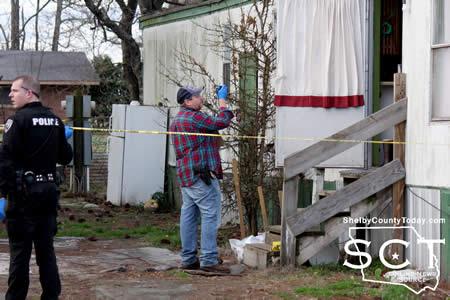
What appeared to be bullet holes on the northern side of the trailer were of obvious interest to officers at the site. Officers were seen interviewing residents of the trailer park.
Melissa Crouch, Precinct 1 Justice of the Peace, was called to the location to perform an inquest inside of the residence. Mangum Funeral Home later transported somone from the scene and the officers left the neighborhood at 6:25pm.
More information will be provided should it be made available by the Center Police Department.


DPS Joins Other Agencies in Angelina County Task Force Wednesday
February 20, 2018 - The Texas Department of Public Safety (DPS) is beginning enforcement efforts across the state focusing specifically on violations of the state’s Move Over/Slow Down law. These periodic enforcement operations by DPS Troopers are planned throughout the year at various locations in Texas, with several operations planned in February. One of those operations will take place in Angelina County on Wednesday, Feb. 21, from 7 a.m. to 11 a.m. and again from 5 p.m. to 8 p.m. The DPS-led task force includes the Lufkin Police Department and the Texas Department of Transportation. TxDOT will be participating in a non-enforcement capacity.
The law, originally passed in 2003, requires motorists to move over or slow down when certain vehicles – including police, fire, EMS, Texas Department of Transportation vehicles and tow trucks – are stopped on the side of the road with emergency lights activated.
“Our Highway Patrol Troopers and other offices risk their lives every day for the people of Texas, and their safety is particularly vulnerable while working on the side of the road, where the slightest mistake by a passing motorist can end in tragedy,” said DPS Director Steven McCraw. “While our officers are serving and protecting Texans, we’re asking drivers to do their part by adhering to the law – simply move over or slow down.”
Specifically, Texas law states that a driver must either:
• Vacate the lane closest to the applicable vehicles stopped on the side of the road (if the road has multiple lanes traveling in the same direction) or
• Slow down to 20 mph below the speed limit. (If the speed limit is below 25 mph, the driver must slow down to 5 mph)
Drivers should only move over if they can do so safely and legally; otherwise, they should slow down.
“In light of the numerous vehicle crashes that occur in Texas and across the nation on a daily basis, and the unfortunate fact that many still violate the state law that has been in effect for nearly 15 years, we are increasing our enforcement and education efforts related to this law,” said Director McCraw. “In addition to complying with the law to protect those who work on the side of the road, we encourage motorists to show the same courtesy to fellow drivers stopped along the roadways. Let’s all get home safely.”
Violations of the law can result in a fine of up to $200; the fine increases to $500 if there is property damage. If violators cause bodily injury, they can be charged with a Class B misdemeanor, resulting in possible jail time and a maximum fine of $2,000.
Preliminary data from 2017 shows that DPS issued more than 10,650 warnings and citations to motorists violating the Move Over/Slow Down law.
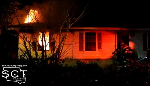
February 20, 2018 - Steady winds blew smoke from a house on fire in Center and alerted neighbors there was something wrong Monday night.
The smoke was traveling in a northerly direction and across State Highway 7 West. A nearby neighbor smelled the smoke before flames became visible from the outside of the structure and quickly called 9-1-1.
The Center Fire Department was dispatched to 100 Shari Street in Center, Texas around 9:29pm Monday, February 19, 2018 for the fire.
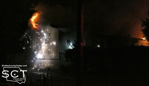
Power line providing service to the house is seen arcing while firemen are nearby working to extinguish the flames.
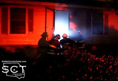 ACE EMS which is located just down the road from Shari Street was alerted by the smoke as well and was first to arrive on scene just moments before the Center Fire Department. At the time of arrival, it was uncertain if anyone was inside the home. Center firemen broke through the front door to gain entrance and began searching inside the smoke filled structure. No one was inside and firemen made quick work of dousing the flames.
The fire did break through into the attic; however, firemen were able to contain it minimizing the fire damage to a bedroom area and the attic. The rest of the house received smoke damage.
A vehicle parked in the garage was unharmed as were nearby homes. The Center Fire Department returned back to the station at 11:30pm.
The house belongs to Allen Gossett, Jr of Center and no one was home at the time of the fire.
February 16, 2018 -
Class I Recall
Health Risk: High
Pilgrim’s Pride Corp., a Waco, Texas establishment, is recalling approximately 101,310 pounds of ready-to-eat breaded chicken patties that may be contaminated with extraneous materials, specifically rubber, the U.S. Department of Agriculture’s Food Safety and Inspection Service (FSIS) announced today.
The ready-to-eat breaded chicken patties were produced and packed on Sept. 6, 2017. The following products are subject to recall: [View labels by clicking here]
30-lb. boxes with six 5-lb. clear bags containing “GOLD KIST FARMS, Fully Cooked Whole Grain Home-Style Breaded Chicken Patties,” with a case code of 72491050xx and a product code of 665400.
The products subject to recall bear establishment number “P-20728” inside the USDA mark of inspection. These items were shipped to institutions nationwide.
The problem was discovered after the firm received a customer complaint on Feb. 13, 2018. Pilgrim's Pride distributed the product to institutions, including schools. Although the product was sold through the USDA commodity program, the introduction of the foreign material was due to an equipment failure at the facility.
There have been no confirmed reports of adverse reactions due to consumption of these products. Anyone concerned about an injury or illness should contact a healthcare provider.
Customers who have purchased these products are urged not to consume them. These products should be thrown away or returned to the place of purchase.
FSIS routinely conducts recall effectiveness checks to verify recalling firms notify their customers of the recall and that steps are taken to make certain that the product is no longer available to consumers. When available, the retail distribution list(s) will be posted on the FSIS website at www.fsis.usda.gov/recalls.
Consumers with questions about the recall can contact James Brown, consumer relations manager at Pilgrim’s Pride Corp., at 1-800-321-1470. Media with questions about the recall can contact Cameron Bruett, head of media relations at Pilgrim’s Pride Corp., at (970) 506-7801.
Consumers with food safety questions can "Ask Karen," the FSIS virtual representative available 24 hours a day at AskKaren.gov or via smartphone at m.askkaren.gov. The toll-free USDA Meat and Poultry Hotline 1-888-MPHotline (1-888-674-6854) is available in English and Spanish and can be reached from 10 a.m. to 6 p.m. (Eastern Time) Monday through Friday. Recorded food safety messages are available 24 hours a day. The online Electronic Consumer Complaint Monitoring System can be accessed 24 hours a day at: http://www.fsis.usda.gov/reportproblem.
USDA Recall Classifications
- Class I This is a health hazard situation where there is a reasonable probability that the use of the product will cause serious, adverse health consequences or death.
- Class II This is a health hazard situation where there is a remote probability of adverse health consequences from the use of the product.
- Class III This is a situation where the use of the product will not cause adverse health consequences.
Pages