

The story headline links to a better view of the story and share features.


News
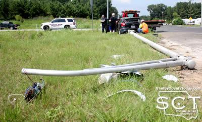
July 27, 2017 - A collision at the intersection of Loop 500 and State Highway 7 sparked a secondary crash on Friday, July 21, 2017.
According to Center PD officer Spencer Anderson, at 3pm a 2006 black Ford F-150 driven by Jody Martin, 29, of Center was northbound on Loop 500 as he approached State Highway 7 East.
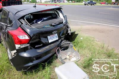
At that time Thomas Thompson, 70, of La. was driving westbound in a 2012 black Ford Focus when he failed to yield right of way for oncoming traffic in a four-way intersection and crashed into the Focus.
Following the initial collision, the Focus spun off the roadway to the right where it struck a light pole with the rear of the vehicle and brought the light pole crashing to the ground.

No injuries were reported resulting from either collision and no citations have been issued at this time.
Both vehicles were towed from the scene. TxDOT was on scene to assess the damage to the pole.
Officer Anderson was assisted at the scene by Officer Kenneth King.


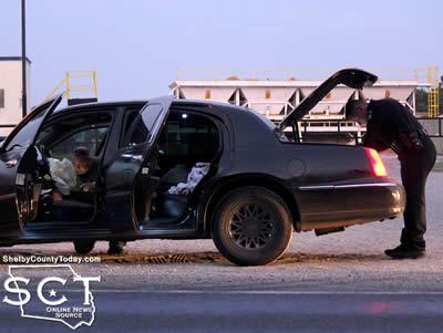
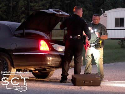
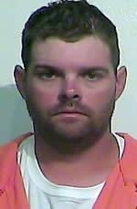
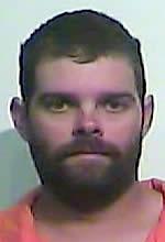
July 26, 2017 - The driver of a vehicle involved in two crashes on the same day was arrested following the discovery of drug paraphernalia Friday, July 21, 2017.
Earlier in the day around 10:30am the Center Police Department (CPD) was contacted about a minor traffic incident from which the driver of a Lincoln Continental fled on Hurst Street. The driver of the second vehicle, a Ford King Ranch driven by Kenneth Campbell, followed the vehicle until CPD officers were able to make contact with the other driver at the intersection of Nacogdoches Street and Hurst Street.

Following an investigation of the incident, the driver of the Lincoln was issued a citation and everyone left the scene.
Later in the evening on the same day, CPD officers responded to a crash incident on Loop 500 to what turned out to be the same Lincoln from the crash earlier in the day. At 8pm a 2001 black Lincoln Continental driven by Brian Buesteton, 33, of Green Valley, Az. was eastbound on Loop 500 when the driver advised as he was approaching Few Ready-Mix Concrete Co. he heard a popping sound and lost control and hit the guardrail.

After colliding with the guardrail, the Lincoln came to a halt in the middle of the westbound traffic lane, facing south.
While performing an inventory of the vehicle CPD officers Steve Thornburgh and Brian Wright discovered drug paraphernalia in the Lincoln.
Buesteton was arrested at the scene and charged with possession of drug paraphernalia.
July 26, 2017 - The jury that has been summoned for Monday, August 7, 2017 for the 123rd Judicial District Court, Hon. Judge LeAnn Kay Rafferty presiding has been cancelled due to the scheduled cases being resolved or passed.
Anyone receiving a summons for that day is released from jury service until they receive a future summons.

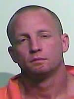
July 24, 2017 - Sheriff Willis Blackwell reports the arrest of Charles Patrick Davis, 31, of Tenaha.
 Davis’ arrest led to the recovery of two Honda ATV’s that were recently reported stolen from the Beck Farm in Huxley owned by C. Scott Massey.
Lieutenant Kevin Windham of the Shelby County Sheriff’s Office (SCSO) was provided photo documentation on July 10 from a game camera that was placed on the Beck Farm. The photos captured two separate occurrences of a white male entering a large metal building on the property. The photos show the suspect inside the building, holding a gasoline can, as if to be putting gas in the ATV which belonged to Massey.
After reviewing the photos from the game camera, SCSO Chief Deputy D.J. Dickerson recognized the suspect as Davis.
A warrant was issued for Davis on July 12. Davis was arrested at the SCSO on July 17. He was charged with Burglary of a Building (F-4), Burglary of a Building (F-4) and Unlawful Possession of a Firearm by Felon (F-3).
After his arrest Lt. Windham interviewed Davis and he admitted to entering the building on the Beck Farm and stealing the ATV’s. Davis also provided Lt. Windham with information that led to the recovery of the ATV’s. The property was recovered and returned to Massey.
Davis was released from the SCSO on July 18 after posting bonds totaling $15,000.
Related Article:
Letter to Sheriff Blackwell Concerning Recent Theft Near Huxley
July 24, 2017 - Runnels is no longer being sought as law enforcement officials are reporting his capture.
According to the Shelby County District Attorney's office, after a week long search, sex offender Donald Runnels has been captured. Runnels absconded last week before his trial was to begin. The investigations division of the Shelby County District Attorney's Office then began to track Mr. Runnels.
He was located in Accomack County Virginia. The District Attorney's Office requested the assistance of Accomack County Sheriff and Mr. Runnels was quickly apprehended. He will be extradited back to Shelby County, where he will face prosecution on 4 felony charges.
July 13, 2017 - The Shelby County District Attorney's office is seeking the whereabouts of Donald Ray Runnels, age 50, of Logansport.
 Runnels has four outstanding warrants: failure to appear for the original charge of evading arrest, offense date June 9, 2014; sexual assault, second degree felony, offense date of June 2, 2016; failure to appear for the original charge of failure to register as a sex offender, offense date of June 6, 2016; and failure to appear for the original charge of failure to register as a sex offender, offense date of July 8, 2016.
Judge Leanne Kay Rafferty, 123rd Judicial District Court, issued a capias warrant for Runnels arrest. On July 5th Judge Rafferty issued an order to appear for July 10, 2017 to which only the attorney for Runnels appeared.
Runnels has a trial date for July 17, 2017 in the 123rd Judicial District Court with Judge Rafferty presiding.
Center Crime Stoppers is offering a cash reward of up to $1,000 for information. Anyone who has information should call Center Crime Stoppers at 936-598-SAFE (7233) or submit a tip online at www.centercrimestoppers.com. Remember you don't have to give your name. All calls and cash rewards are completely anonymous. Rewards will only be paid on tips submitted through the Center Crime Stoppers system.
If a caller does not wish to remain anonymous or receive a reward, they may call the Shelby County Sheriff's Office at 936-598-5600.
If anyone is found to be hindering the apprehension, harboring or concealing, providing or aiding with any means of avoiding arrest or effecting escape or warns Runnels of impending discovery or apprehension will be arrested and charged in accordance to Penal Code 38.05 Hindering Apprehension or Prosecution, a Felony 3 offense.
July 24, 2017 - The following cases were recently disposed of in the Shelby County Court during the months of June and July 2017. Judge Allison Harbison was the presiding Judge and County Attorney Gary Rholes represented the State.
- Marsh Odom – Criminal Mischief (Class B) - - $400.00 fine, $262.00 court cost, Final Judgement.
- Christopher Pleasant – Theft (Class B) - - $400.00 fine, $262.00 court cost, Final Judgement.
- Jubert Segovia – Driving While Intoxicated (Class B) - - $1200.00 fine, $412.10 court cost, Final Judgement.
- Durankus Solomon – Possession of Marijuana (Class B) - - $600.00 fine, $322.00 court cost, 12 months of probation, 40 hours Community Service, attend and complete Drug Offender Program.
- Charles Edwards – Assault Family Violence (Class A) - - $500.00 fine, $262.00 court cost, 30 days in the Shelby County Jail.
- Donald Land – Theft (Class B) - - $600.00 fine, $262.00 court cost, $500 restitution, 12 months of probation, 20 hours Community Service, attend and complete Theft Program.
- Dakota Rodgers – Theft (Class B) - - $500.00 fine, $262.00 court cost, 40 days in the Shelby County Jail.
- Young Jackson – Assault Family Violence (Class A) - - $600.00 fine, $262.00 court cost, 12 months of probation, attends and complete Anger Management Program
- Ervey Garcia – Assault (Class A) - - $600.00 fine, $262.00 court cost, Final Judgment.
- Juan Robledo – Reckless Driving (Class B) - - $500.00 fine, $262.00 court cost, Final Judgement.
- Larry Barrett – Probation Revocation, original charge: Possession of a Controlled Substance (Class A) - - 8 months in the Shelby County Jail.
- Tracy Whitaker – Burglary of a Vehicle (Class A) - - $700.00 fine, $262.00 court cost, 40 hours Community Service, attend and complete Theft Program.
- Alexander Vargas – Obstructing a Public Roadway (Class A) - - $1200.00 fine, $262.00 court cost, Final Judgement.
- Chelsea Lout – Probation Revocation, original charge: Theft (Class A) - - 4 months in the Shelby County Jail
- Alan Runnels – Indecent Exposure (Class A) - - $700.00 fine, $262.00 court cost, Final Judgement.
- David Cox – Interference with an emergency phone call (Class A) - - $262.00 court cost, 10 days in the Shelby County Jail.
- Troy Kenderdine – Driving While Intoxicated 2nd (Class A) - - $1600.00 fine, $412.10 court cost, 12 months of probation, 40 hours Community Service, attend and complete a repeat offenders DWI education program, and install ignition interlock system.
- Sarah Smith – Terroristic Threat (Class B) - - $600.00 fine, $262.00 court cost, 60 days in the Shelby County Jail.
- Sarah Smith – Unlawful Carrying Weapon (Class A) - - $400.00 fine, $262.00 court cost, 60 days in the Shelby County Jail
- Tony Smith – Driving While License Suspended (Class B) - - $500.00 fine, $262.00 court cost, Final Judgement.
- Charles Barrett – Driving While License Suspended (Class B) - - $500.00 fine, $262.00 court cost, Final Judgement.
- Chad Taylor – Resisting Arrest (Class A) - - $600.00 fine, $262.00 court cost, 27 days in the Shelby County Jail.
- Chad Taylor – Possession of Marijuana (Class B) - - $322.00 court cost, 27 days in the Shelby County Jail.
- Rebecca Blaylock – Theft (Class B) - - $600.00 fine, $262.00 court cost, 6 months Deferred Adjudication, attend and complete Theft program.
- TyKerria Ross – Display Fictitious Registration (Class B) - - $550.00 fine, $262.00 court cost, 40 hours Community Service.
- Angel Hernandez – Furnishing Alcohol to a Minor (Class A) - - $700.00 fine, $262.00 court cost, 40 hours Community Service.
- Dominic Collins – Driving While License Suspended (Class B) - - $500.00 fine, $262.00 court cost, Final Judgement.
- Dustin Hearne – Theft (Class B) - - $600.0 fine, $262.00 court cost, 30 days in the Shelby County Jail.
- Christina Tarver – Criminal Mischief (Class B) - - $600.00 fine, $262.00 court cost, 6 months of probation
- Jarvis Taylor – Possession of Marijuana (Class B) - - $322.00 court cost, 60 days in the Shelby County Jail.
- Jarvis Taylor – Resisting Arrest - - $292.00 court cost, 60 days in the Shelby County Jail.
- Jarvis Taylor – Probation Revocation, original charge: Assault (Class A) - - 150 days in the Shelby County Jail.
- Dixie Francis – Theft (Class B) - - $600.00 fine, $262.00 court cost, 12 months of probation, 40 hours Community Service Restitution, attend and complete Theft program.
- Dixie Francis – Resisting Arrest (Class A) - - $700.00 fine, $292.00 court cost, 12 months of probation, 40 hours Community Service Restitution.
- Michael Hawley – Theft (Class B) - - $600.00 fine, $262.00 court cost, 12 months of probation, 40 hours Community Service, attend and complete Theft program.
- Fernando Garza – Driving While Intoxicated 2nd (Class A) - - $1600.00 fine, $412.10 court cost, 12 months of probation, 40 hours Community Service, attend and complete repeat offenders program, install ignition interlock system.
- Pamela Stickle – Theft (Class B) - - $600.00 fine, $262.00 court cost, 12 months of probation, 40 hours Community Service, attend and complete Theft program.
- David Stickle – Theft (Class B) - - $600.00 fine, $262.00 court cost, 12 months of probation, 40 hours Community Service, attend and complete Theft program.
- James Hoffpauir – Display Fict. License Plate - - $262.00 court cost, 9 days in the Shelby County Jail.
- James Hoffpauir – Driving While License Suspended (Class B) - - $262.00 court cost, 9 days in the Shelby County Jail.
- Nathan Peace – Deadly Conduct (Class A) - - $600.00 fine, $262.00 court cost, 60 hours Community Service, 60 days in the Shelby County Jail.
- Felicia Doster – Possession of Controlled Substance (Class A) - - $700.00 fine, $322.00 court cost, 12 months of probation, 40 hours Community Service, attend and complete Drug Offender program.
- Jonathan Lout – Assault Family Violence (Class A) - - $500.00 fine, $262.00 court cost, 25 days in the Shelby County Jail.
- Seth Golladay – Assault Family Violence (Class A) - - $600.00 fine, $262.00 court cost, 24 days in the Shelby County Jail.
- Degarim Walter – Possession of Marijuana (Class B) - - $300.00 fine, $322.00 court cost, Final Judgement.
- April Gibbs – Driving While Intoxicated (Class B) - - $1200.00 fine, $412.10 court cost, 12 months of probation, 40 hours Community Service, attend and complete DWI education program.
- Jeffery Scott – Possession of Marijuana (Class B) - - $400.00 fine, $322.00 court cost, Final Judgement.
- Daniel Eaves – Probation Revocation, original charge: Driving While Intoxicated - - 60 days in the Shelby County Jail.
- Christie Fleming – Fail to Identify (Class A) - - $600.00 fine, $262.00 court cost, Final Conviction.
- Keodrick Boyd – Evading Arrest (Class A) - - $292.00 court cost, 17 days in the Shelby County Jail.
 July 21, 2017 - Center Police Department Officers Angela Neal and Chris King were notified of a minor traffic accident in the 1100 block of Tenaha St. on Monday July 17th 2017 at approximately 6:24pm. Upon arrival officers discovered that the driver of a 2012 Black Dodge Ram was attempting to make a right turn into a private drive.
The driver of the 2007 Lincoln MKZ, Shelby Rodriquez, 25, of Timpson, Texas was traveling behind the Dodge when she attempted to pass the vehicle on the right. Rodriquez's vehicle was then struck by the Dodge Pickup.
Upon contact with Rodriquez, officers discovered that she was intoxicated. It was also discovered that Rodriquez had a child passenger and an adult male passenger that had fled the scene on foot. The child and passenger were located a short time later in a nearby wooded area.
The male passenger was identified as Josh Parker 35 year old white male of Center, Texas. The four year child was released to Child Protective Services a short time later.
Shelby Rodriquez was arrested for Driving while Intoxicated/child under 15, State Jail Felony, and Abandoning or Endangering a Child, State Jail Felony.
Josh Parker was arrested for Public Intoxication, Class C Misdemeanor and Abandoning or Endangering a Child, State Jail Felony.
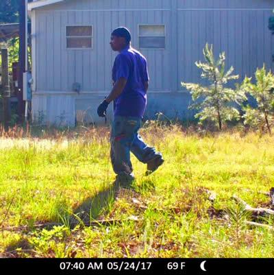
July 21, 2017 - The Shelby County Sheriff’s Office is seeking information and assistance in identifying a suspect involved in a recent burglary that occurred in the Stockman Community on two different occasions between May 25th and May 27th, 2017.
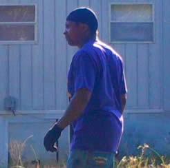 The suspect depicted in the photograph cut the locks on the Sheridan gas well gate and gained entry to a property in the Stockman Community. Once on the property, the suspect stole all the appliances from inside the unoccupied residence which included a washer, dryer, refrigerator, stove, dishwasher, and two portable air conditioners among other things. The suspect was captured by a motion sensor camera also carrying a chainsaw that was taken from the property.
Center Crime Stoppers is offering a cash reward of up to $1,000 for information. Anyone who has information regarding this crime should call Center Crime Stoppers at 936-598-SAFE (7233) or submit a tip online at www.centercrimestoppers.com. Remember you don't have to give your name. All calls and cash rewards are completely anonymous. Rewards will only be paid on tips submitted through the Center Crime Stoppers system.
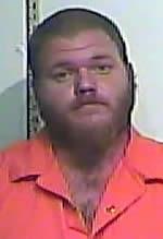
 July 20, 2017 - Following their arrests on Wednesday, July 19, 2017 Randa McMahon and Matthew McMahon on the charge of endangering a child, state jail felony, the respective defense attorneys for each filed writs of habeas corpus seeking reduction in bail.
The writs of habeas corpus each stated the $200,000 bonds for each of the McMahons were excessive, and reflected the previous bonds of $20,000 which each of the McMahons are already out on and stated meeting an additional bail amount would be impossible.
McMahons went before LeAnn Rafferty, 123rd Judicial District Judge, Thursday, July 20, 2017 and the bond was reduced to a $2,500 bond which was agreed to as neither of the McMahons had ability to make the original set bond.
Both parties are prohibited from contact with the victim, the temporary guardian and an additional minor child.
Related Articles:

 July 19, 2017 - Two individuals arrested on child abuse charges in June have been re-arrested following a hearing to determine the custody of the child involved.
Matthew McMahon, 29, and Randa Askew Faust McMahon, 36, both of Shelbyville were arrested in the Shelby County Courthouse by Joey Haley, District Attorney Investigator, and they were transported to the Shelby County Jail for charges of endangering a child, state jail felony.
According to the arrest affidavit attributed to Shelby County Sheriff's Department Investigator Chad Brown relating to each, the McMahons are alleged to have engaged in conduct that placed a child, who is under 15 years of age, in imminent danger of death, bodily injury, or physical or mental impairment by allowing the child's potassium, protein, and albumin levels to all fall to very low levels. At least the potassium level was reduced to a dangerously low, life-threatening level.
These effects are all alleged to be due to "chronic nutritional deficiency" while under the McMahon's custody and care, and that they did not seek any medical attention for that condition.
The affidavit further explains, the child was removed from the custody of the McMahons on June 1, 2017 and on June 5, 2017 the child was admitted to Nacogdoches Medical Center for various medical problems stemming from injuries the child had on his right buttock and right arm. It was immediately determined at the hospital, the child suffered from hypoalbuminemia and hypoproeinemia from "chronic nutrition deficiency."
Blood work done on the child at that time indicated his potassium level was "2.8." The doctor who was treating the child immediately ordered and started I.V. fluids with potassium added to it. The decision was made that due to the acute hypokalemia (low level potassium), the child required a higher level of care than was available at Nacogdoches Medical Center and he was to be (and subsequently was) transferred to Texas Children's Hospital in Houston, Texas.
The child custody case which the McMahons had been attending ruled for the child to remain at this time in the custody of the intervenor with whom he was originally placed.
Each of the McMahons are being held once again in the Shelby County Jail on pre set $200,000 bonds.
Related article:
Pages