

The story headline links to a better view of the story and share features.


News

October 5, 2024 - The Poultry Festival Chicken Fun Run/Chicken Trot is now has reached completion Saturday, October 5, 2024 and the top runners were men’s overall Fabio Rubeck and women’s overall Anna Hagler.
Additional results are pending.


October 5, 2024 - The Poultry Festival Chicken Fun Run/Chicken Trot is now off and running Saturday, October 5, 2024 from Portacool Park. There’s still time to show up and cheer friends and family across the finish line! As of 8:13am.
October 4, 2024 - The photography contest is located at the team of the first Baptist Church.
People’s Choice voting is in process for today, Friday only please be sure to come by and make your selections of the photograph you like the best.
The quilt show and the art and craft show is also located there. Please come by.

Farmers State Bank presents the 48th East Texas Poultry Festival on the downtown Center square October 3rd, 4th, and 5th.
Click here for FOOD BOOTH MENU and Coupon Prices
Enjoy Entertainment throughout the Festival on the Frances Oates Main Stage. Vocalists and bands are in green in the schedule below.
The Creative Arts Show, Quilt Show, and Photography Show is located inside First Baptist Church Family Life Center gym.
Entry buttons are $5 and cover all three days. Carnival Ride Wrist Bands are $25 and are only available Thursday (6-10pm), Friday (1-5pm), and Saturday (1-5pm).
Thursday, October 3, 2024
9:00am - Shelby County Ag Mechanics will start judging.
10:00am - Opening Ceremonies on the Historic Downtown Center Square (Sponsored by Focused Care of Center)
- Invocation: Pastor Malcolm Monroe, Center 1st Methodist Church
- National Anthem played by Center HS Band, directed by Chris Smith
- Pledge to the Flag recited by Timpson ISD Kindergarten
- Welcome from local officials and Shelby County Chamber of Commerce President
- Cutting of the Feathers by 2024 East Texas Poultry Festival Queens and Court
10:00am - Food / Arts & Crafts Booths Open
10am to 5pm - Creative Arts Show inside First Baptist Church Family Life gym (Sponsored by Doches Credit Union)
10am to 5pm - Quilt Show inside First Baptist Church Family Life gym (Sponsored by Scull Timber Company)
10am to 5pm - Photography Show inside First Baptist Church Family Life gym (Sponsored by The Light and Champion)
10:20am - “Flashback to the Fifties” Shelbyville 4th Grade Class
10:45am - F.L. Moffett Kindergarten Classes
10:45am - Araiza, Nunez, Fults
11:00am - Buenrostro, Horn, Golden
11:15am - Ribera, Battles
11:30am - F.L. Moffett First Grade Classes
11:30am - Sullivan, Ruiz, Gonzalez
11:40am - Yarbrough, Spence, Ventura
11:50am - Amaya, Collins, Jurecka
12 noon - F.L. Moffett Second Grade Classes
12 noon - Hairgrove, Radney, Burkert
12:15pm - Helms, Parker, Combs
12:25pm - Cockrell, Long, Ruiz-Siso
1:30pm - Charles Delaney
2:00pm - Quilts of Valor
3:00pm - Center High School Theater Class, 3 Little Pigs Play
4:45pm - Chase Mayfield
5:30pm - TXC Junkyard
6:00pm - Carnival Opens
6pm to 10pm - ***Carnival Rides (Wrist Bands $25)***
6:15pm - Jacob Wheeler and Jackson Wendell, Acoustic SongSwap
7:30pm - Danny Paul Windham with Pack of Strays 2 and Special Guest
10:00pm - Festival Closes
Friday, October 4, 2024
10:00am - Food / Arts & Crafts Booths Open
10:00am - Magic/Chemistry Show with Brooke Harrison - Under Tent
10am to 5pm - Creative Arts Show inside First Baptist Church Family Life gym (Sponsored by Doches Credit Union)
10am to 5pm - Quilt Show inside First Baptist Church Family Life gym (Sponsored by Scull Timber Company)
10am to 5pm - Photography Show inside First Baptist Church Family Life gym (Sponsored by The Light and Champion)
11:00am - Excelsior School Choir directed by Tim Verner
12 noon - Danny Paul and Sally Windham and Friends (SongSwap)
1:00pm - ***Carnival Rides (Wrist Bands $25, 1pm-5pm)***
1:30pm - Jayne and Jessica
2:15pm - Daily Dose Ballet
3:00pm - Bad Boy Leroy
5:00pm - Jessica Hopkins with the Pack of Strays
6:30pm - Cole Stephens
7:30pm - Ketzaly - Mexican Folklore Dance
8:00pm - Conjunto Fortaleza
11pm - Festival Closes
Saturday, October 7, 2023
7:30am - Poultry Festival Chicken Fun Run/Chicken Trot with 5K at 8am at Portacool Park (Presenting Sponsor - Axley and Rhode; Awards Sponsor - Cline Family Medicine; 5K T-Shirt Sponsor - All Hours Fitness, Debrah J. Worsham, DDS, Sandhill Wrecker Service, LLC, and Tomlin Insurance; Refreshments Sponsor - Town & Country Real Estate)
***Proceeds go to Rotary Club of Center
8am to 10am - Broiler Show Sift at the Rodeo Arena
10am until completion - Broiler Show Judging at the Rodeo Arena
10:00am - Self Defense America Showcase
10:00am - Food / Arts & Crafts Booths Open
10am to 2pm - Car and Motorcycle Show downtown square (Sponsored by Raymond Motor Company)
10am to 3pm - Creative Arts Show inside First Baptist Church Family Life gym (Sponsored by Doches Credit Union)
10am to 3pm - Quilt Show inside First Baptist Church Family Life gym (Sponsored by Scull Timber Company)
10am to 3pm - Photography Show inside First Baptist Church Family Life gym (Sponsored by The Light and Champion)
10:30am - Passenger Unknown
10am to 3pm - Creative Arts Show - First Baptist Church gym
10am to 3pm - Quilt Show - First Baptist Church gym
10am to 3pm - Photography Show - First Baptist Church gym
11:00am - Zoey Green
11:30am - Wing it - Wing Eating Competition Sign-up on the Main Stage (Presenting Sponsor Tyson Foods, Awards Sponsor McWiliams and Sons)
12-noon - Wing it - Wing Eating Competition on the Main Stage (Presenting Sponsor Tyson Foods, Awards Sponsor McWiliams and Sons)
1:00pm - Carnival Opens
1pm to 5pm - ***Carnival Rides (Wrist Bands $25)***
1:00pm - Old Town Brass Band
2:15pm - Vernon Washington AKA The Don
3:15pm - Shelby County Ag Mechanics Awards (Stage)
3:30pm - Jessica Hopkins & Daughters
4:00pm - Rhythm Rocker Cloggers
4:00pm - Tim and Jessica Hopkins and Family
4:45pm - "Strut, Cluck and Crow" Chicken Clucking Contest Sign-up on the Main Stage (Sponsored by Deborah Worsham, DDS) and Awards (Sponsored by Tammy Steptoe Realty)
5:00pm - Ag Mechanics Live Auction on Austin Street side at the Ag Mechancs Trailer (Awards sponsored by Light and Champion)
5:15pm - "Strut, Cluck and Crow" Chicken Clucking Contest on the Main Stage (Sponsored by Deborah Worsham, DDS) and Awards (Sponsored by Tammy Steptoe Realty)
6:30pm - Raffle Drawings: Lions Club Truck, Quilt, Rotary Generator, SCOM 4X4, and more on Main Stage
7:00pm - 4-H and FFA Broiler Show Auction on the Frances Oates Stage on the Center square (Sponsored by Timberwolf Lake Works)
11pm - Festival Closes

Click above 'Thank You!' to view sponsors!
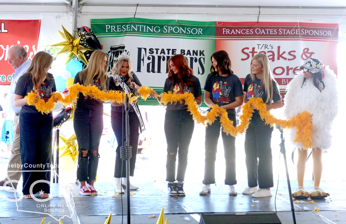
October 3, 2024 - The 48th Annual East Texas Poultry Festival (ETPF) is now open following the official feather cutting ceremony October 3, 2024.
Members of the East Texas Poultry Festival Queen’s Court gathered on the Frances Oates stage and Queen Lillian Chisenhall performed the honor of cutting the feathers.
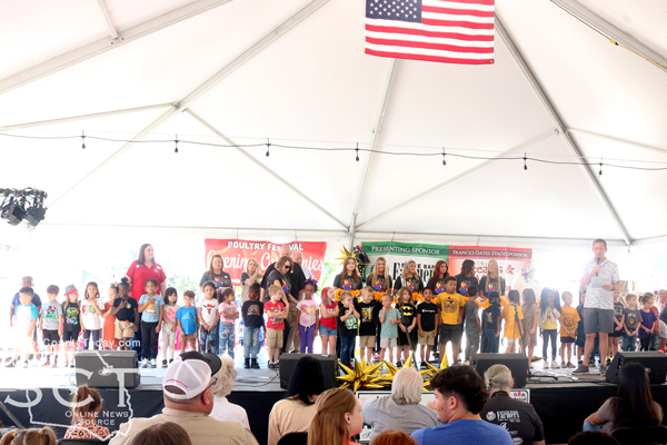
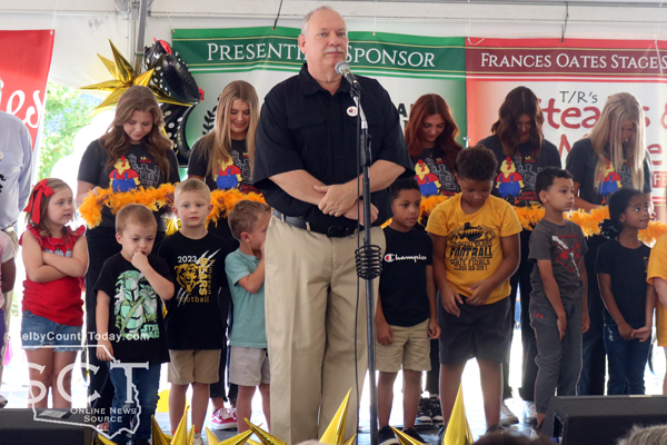
Josh Payne, Chairman of the 48th Annual East Texas Poultry Festival, was the master of ceremonies for the opening and he first introduced Pastor Malcolm Monroe of First Methodist Church to offer the invocation for the event. The Center High School band then performed the National Anthem and the Timpson Kindergarten class then recited the Pledge of Allegiance.

David Chadwick, Center Mayor/President Farmer’s State Bank, welcomed everyone to the ETPF and recalled its beginning and it being almost impossible to believe that was 48 years ago and how much the festival has changed since its early years.
“It was nothing like this, this is unbelievable how it has grown,” said Mayor Chadwick. “But, you stop and you look at our county and our city and how it has grown, and how much of that we owe to the poultry industry.”
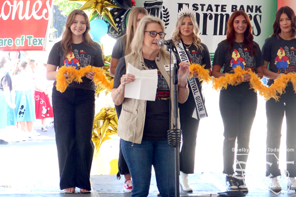
Allison Harbison, Shelby County Judge, expressed pride in representing Shelby County and welcomed everyone.
“I feel so blessed to live in a small county that is made up of wonderful friendly communities,” said Judge Harbison. “Today I want to challenge each of you children and adults to make your world a better place, it’s really not that hard.”
She encouraged and challenged all to show kindness and proactivity.
“I challenge you to make your community a kinder, friendlier place to live and it is truly an honor to be your County Judge and it is so nice to see you today, and I hope you have a great time at the poultry festival,” said Judge Harbison.

Brandy Filz, 2024 Chairman of the Board of Directors of the Shelby County Chamber of Commerce, spoke on behalf of the Chamber of Commerce.
“This is a time to enjoy our community and to support our poultry industry that is one of the major economic basis of our economy here in Shelby County,” said Filz.
She thanked all the volunteers who freely and generously give of their time.
“I’m looking forward to a fun 2024 poultry Festival and I hope everyone has a good time,” said Filz.

Payne allowed each of the Queen’s Court members to introduce themselves and then Queen Chisenhall proceeded to cut the ceremonial feathers, and the 48th Annual East Texas Poultry Festival was declared officially open!
Shelby County Today will be updating regularly throughout the East Texas Poultry Festival. Check back regularly and be sure to visit the square for food, activities and fun!
Related articles:
October 2, 2024 - A Shelby County Grand Jury handed down 26 indictments on Tuesday, September 24, 2024. The grand jury was impaneled for the July 2024 term of the 123rd/273rd Judicial District Courts.
Adan Pecina was indicted for aggravated assault with a deadly weapon, second degree felony. The indictment alleges, on March 26, 2024 Pecina used or exhibited a deadly weapon, to-wit a handgun, and threatened imminent bodily injury to Juanita Trejo by pressing a handgun against her chest. (273rd Judicial District Court)
Adan Pecina was indicted for abandon/endanger child individual imminent danger bodily injury, second degree felony. The indictment alleges, on March 29, 2024 Pecina engaged in conduct that placed a child younger than 15 years of age in imminent danger of death, bodily injury, or physical or mental impairment by pointing a gun at the child while the mother was holding said child. (273rd Judicial District Court)
Adan Pecina was indicted for burglary of a habitation, first degree felony. The indictment alleges, on March 26, 2024 Pecina entered a habitation without the effective consent of Juanita Trejo, the owner thereof, and attempted to commit or committed the felony offense of aggravated assault with a deadly weapon. (273rd Judicial District Court)
Richard Arvello was indicted for assault by choking, third degree felony. The indictment alleges, on February 7, 2024 Arvello caused bodily injury to Dawn Arvello, a member of Richard Arvello's family, as described by section 71.003 of the Texas Family Code, by impeding the normal breathing or circulation of the blood of the complainant by blocking the nose or mouth of Dawn Arvello. (273rd Judicial District Court)
Richard Arvello was indicted for aggravated assault causing serious bodily injury, second degree felony. The indictment alleges, on February 7, 2024 Arvello caused serious bodily injury to Dawn Arvello by hitting her in the head with his fists, slapping both sides of her head with his hands, throwing a wooden stool at her while in the bathtub, dragging her into the house and kicking her repeatedly, which caused serious bodily injury to Dawn Arvello. (123rd Judicial District Court)
Marcus Lance Horton was indicted for assault by choking, third degree felony. The indictment alleges, on July 29, 2024 Horton caused bodily injury to Lindsey Anders, a person with whom Horton had a dating relationship, as described by section 71.021(b) of the Texas Family Code, by impeding the normal breathing or circulation of the blood of Anders by applying pressure to the throat or neck of Anders. (273rd Judicial District Court)
Bobby Darnell Johnson was indicted for assault by choking, third degree felony. The indictment alleges, on August 25, 2024, Johnson caused bodily injury to Ariel Pelzer a person with whom Johnson had a dating relationship, as described by section 71.021(b) of the Texas Family Code, by impeding the normal breathing or circulation of the blood of Pelzer by applying pressure to the throat or neck of Pelzer. (123rd Judicial District Court)
Alan Diaz aka Alan Chavez Diaz; Alan Diazchavez; Alan Diaz-Reyes was indicted for evading arrest in a motor vehicle, state jail felony. The indictment alleges, on June 4, 2024 Diaz, while using a vehicle, intentionally fled from Constable Taylor Fanguy, a person Diaz knew was a peace officer who was attempting lawfully to arrest or detain Diaz. (123rd Judicial District Court)
Vincent Ardontate Buckley was indicted for driving while intoxicated with a child passenger, state jail felony. The indictment alleges, on April 28, 2022, Buckley operated a motor vehicle in a public place while intoxicated by reason of the introduction of a controlled substance, a drug, or a dangerous drug into the body, and the vehicle was occupied by six passengers who were then and there younger than 15 years of age. (123rd Judicial District Court)
Deaundra Deshawn Dones was indicted for felony driving while intoxicated, third degree felony. The indictment alleges, on November 19, 2023, Dones operated a motor vehicle in a public place while intoxicated by not having the normal use of mental or physical faculties by reason of the introduction of alcohol, a controlled substance, a drug, or a dangerous drug into the body. The indictment further presented Dones was convicted on December 7, 2021 and August 15, 2023, of similar offenses of operating a motor vehicle while intoxicated. (273rd Judicial District Court)
Joshua Ryan Daniel was indicted for deadly conduct discharge firearm, third degree felony. The indictment alleges, on June 27, 2024, Daniel discharged a firearm in the direction of John Escobedo. (123rd Judicial District Court)
Joshua Ryan Daniel was indicted for unlawful possession of firearm by felon, third degree felony. The indictment alleges, on June 27, 2024 Daniel did then and there, having been convicted of the felony offense of assault public servant on August 16, 2019 in Harris County, intentionally and knowingly possessed a firearm before the fifth anniversary Daniels release from confinement following conviction of the felony. (123rd Judicial District Court)
Rosalino Lopez Sanchez was indicted for felony driving while intoxicated, third degree felony. The indictment alleges, on June 7, 2024 Sanchez operated a motor vehicle in a public place while intoxicated by not having the normal use of mental or physical faculties by reason of the introduction of alcohol, a controlled substance, a drug, or a dangerous drug into the body. The indictment further presents Sanchez was convicted in Angelina County on January 24, 2022 for operating a motor vehicle while intoxicated 3rd or more. (273rd Judicial District Court)
X'Zavier Keandre Cartwright was indicted for engaging in organized criminal activity, third degree felony. The indictment alleges, on February 9, 2024, Cartwright with intent to establish, maintain, or participate in a combination or in the profits of a combination, the combination consisting of Cartwright, Mason Perry, Sadariant Megee, Colton Jones, and Kaden Cartwright who collaborated in conspiring to commit burglary of a building by agreeing with each other that they would engage in conduct that constituted the offense. The indictment further alleges Cartwright, Mason Perry, Sadariant Megee, Colton Jones, and Kaden Cartwright performed an overt act in pursuance of the agreement, namely, cutting a hole in a fence and stealing a 2023 Polaris MV. (123rd Judicial District Court)
Kaden Cartwright was indicted for engaging in organized criminal activity, third degree felony. The indictment alleges, on February 9, 2024, Cartwright with intent to establish, maintain, or participate in a combination or in the profits of a combination, the combination consisting of Cartwright, Mason Perry, Sadariant Megee, Colton Jones, and X'Zavier Cartwright who collaborated in conspiring to commit burglary of a building by agreeing with each other that they would engage in conduct that constituted the offense. The indictment further alleges Cartwright, Mason Perry, Sadariant Megee, Colton Jones, and X'Zavier Cartwright performed an overt act in pursuance of the agreement, namely, cutting a hole in a fence and stealing a 2023 Polaris MV. (273rd Judicial District Court)
Rocky Lane Jackson was indicted for aggravated assault date/family/house with weapons serious bodily injury, first degree felony. The indictment alleges, on August 19, 2024 Jackson caused serious bodily injury to Cynthia Johnson by hitting her, pulling her hair, and striking her with a metal pipe, and Jackson used or exhibited a deadly weapon, namely a metal pipe, during the commission of the assault. The indictment further presents Johnson was a person with whom Jackson has or has had a dating relationship, as described by section 71.021(b) of the Texas Family Code. (123rd Judicial District Court)
Dakota Lee Marsh was indicted for unauthorized use of a motor vehicle, state jail felony. The indictment alleges, on August 2, 2024, Marsh operated a 2018 gray Chevrolet Silverado without the effective consent of Marlin Jones, the owner. (273rd Judicial District Court)
Armando Javier Huerta was indicted for prohibited substance in a correctional facility, third degree felony. The indictment alleges, on May 3, 2023, Huerta took a controlled substance, namely methamphetamine, into the Shelby County Jail which is a correctional facility. (123rd Judicial District Court)
Vincent Amos Moses Aaron was indicted for theft of property >=$2,500<$30K, state jail felony. The indictment alleges, on April 1, 2024, Aaron took a yellow Case Skid Steer valued at $2,500 or more but less than $30,000 from Larry Smith, the owner, without the effective consent of Smith, and with intent to deprive Smith of the property. (123rd Judicial District Court)
(Some of the following content contained within indictments is of a sensitive nature and may not be suitable for younger viewers.)
Gustavo Garcia was indicted for aggravated sexual assault, first degree felony. The indictment alleges, on May 4, 2024 Garcia caused the penetration of the sexual organ of a person who was a disabled individual by Garcia's sexual organ, and without the consent of that individual. (123rd Judicial District Court)
(Dates in parenthesis indicate the date of the alleged incident):
- Buddy Lee Bradshaw, possession of a controlled substance PG1/1-B <1G (methamphetamine), state jail felony (February 12, 2024). (273rd Judicial District Court)
- Michelle Mae Hughes, possession of a controlled substance PG1/1-B <1G (methamphetamine), state jail felony (May 10, 2024). (123rd Judicial District Court)
- Travoski Rhodes, possession of a controlled substance PG1/1-B >=1G<4G (methamphetamine), third degree felony (April 26, 2024). (273rd Judicial District Court)
- Derrick Okeith Calhoun, possession of a controlled substance PG1/1-B >=4G<200G (methamphetamine), second degree felony (March 25, 2024). (123rd Judicial District Court)
- Mark Allen Stone, possession of a controlled substance PG1/1-B >=4G<200G (methamphetamine), second degree felony (November 3, 2023). (123rd Judicial District Court)
- Quanyette Shaynay Stevenson, possession of a controlled substance PG1/1-B >=1G<4G (phencyclidine), third degree felony (February 8, 2024). (273rd Judicial District Court)
Indictments and Information are not a conviction, and are a matter of public record. All individuals are presumed innocent until found guilty in a court of law.
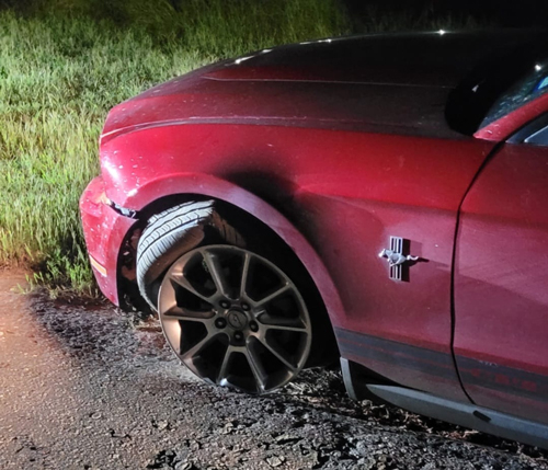
Photo Nacogdoches County Precinct 3 Constable.
October 2, 2024 - A pursuit of a suspect fleeing Texas Department of Public Safety (DPS) State Troopers began in Nacogdoches County ended in Shelby County Friday, September 27, 2024.
Law enforcement officials in Shelby County joined in and assisted as the pursuit entered the county until its completion. Several units with the Center Police Department were prepared for the vehicle at the intersection of State Highway 7 West and SL 500 just before the pursuit came to an end. It was fortunate that as the pursuit was ongoing, crowds of people were still enjoying local football games and had not yet gotten on the road to travel home.
According to information from Texas DPS, Troopers arrested a Nacogdoches man following a vehicle pursuit that began on U.S. Highway 59, and ended near County Road 1168 on State Highway 7.
The preliminary investigation indicates that at approximately 8:11pm, a Trooper initiated a traffic stop on a 2010 Ford Mustang driven by Jonathan Martinez, 19, of Nacogdoches for failing to display their license plates. It is reported that when the Trooper activated his emergency lights and sirens, Martinez began to actively flee. Martinez actively fled from law enforcement officers for approximately 60 to 70 miles throughout Nacogdoches and Shelby County before blowing a tire and coming to a stop.
This is an ongoing investigation, and according to DPS no further information is available at this time.
The Nacogdoches County Constable Precinct 3 office elaborated further on what occurred via a social media post stating that as the pursuit began, the DPS Trooper involved contacted DPS dispatch and reported the pursuit at speeds over 120 mph and that he was crossing over into Angelina County. Other Troopers joined in the pursuit of the Mustang as it turned around and headed back to Nacogdoches where Nacogdoches Police Department officers, and Nacogdoches Constable Precinct 4 assisted as the evading vehicle traveled Loop 224.
Pursuing vehicles traveled behind the Mustang on University Drive and onto Main Street, three blocks from downtown Nacogdoches.
According to the information from the Precinct 3 Constable office, the chase then turned onto Loop 224 once again before traveling onto State Highway 7 where the Mustang led officers for around 20 miles and into Shelby County before the route finally ended on CR 1168.

September 30, 2024 - San Augustine Street in Center was the scene of a crash incident with a house and several vehicle at the location on Sunday, September 15, 2024.
Emergency personnel were dispatched to the location in the 800 block of San Augustine Street at around 2pm.
According to the Center Police Department, a grey 2021 Dodge pickup truck driven by Eh Say, 52, of Center was northbound on Old San Augustine Street when it traveled straight through a curve in the roadway and left the road to the right where it traveled through a yard. The truck continued into a neighboring carport where it ran over three motorcycles before crashing into a garage.

No injuries were reported resulting from the crash.
The Center Fire Department was dispatched to the scene to help Say get out of the truck.
The crash was investigated by Center Police Officer Michael Davidson.
September 26, 2024 - The following individuals have active arrest warrants issued from the 123rd Judicial District Court, Shelby County, Texas:
- Angel Gonzalez
- Brandi Michelle Chevalier
- Brandon Cummings
- Brandon K Smith
- David Treston Wilson
- Denise Simone Garrett
- Ethan Scott Ray
- Hai Chrit
- Jacorey Semone Johnson
- Joeanna Michelle Williams
- Jonathan Erivin Cousin
- Jose Gustavo Aviles
- Jose Higino Zamarron-Fraga
- Jose Juis Mendoza Baylon
- Joseph Jarahd Whitaker
- Keisha Renae Shavers
- Kenneth Grimes
- Kylon Marquell Polk
- Ladaryl Dewayne Burns
- Luis Alberto Ruiz
- Manuel Samtut
- Marcus Kentrell Howard
- Michael Dewayne Blackwell
- Miguel Angel Suarez
- Randall Ray Byrd
- Redaryll Zacharvick Davis
- Ricardo Chavez Veliz
- Ricardo Zarate-Vazquez
- Rosendo Gallegos
- Savannah Stubblefield
- Sean Campbell Davis
- Shanen Gore
- Tierra Lashun Byrd
- Tomas Torres Aguilar
- Tonya Lynn Parks
- Tramaury Rashad Barnes
These individuals must contact the 123rd Judicial District Court Manager, Erin Johnson, 903.693.0315 or erin.johnson@co.panola.tx.us, to schedule a court appearance.
Alternatively, if you have any information regarding the whereabouts of these individuals, please contact the Shelby County Sheriff's Office, 936.598.5601.
September 24, 2024 - The Shelby County Commissioners granted the Shelby County Children's Advocacy Center (SCCAC) with almost $13,000 in capital credits during the September 11, 2024 meeting, and moved forward in allowing the Sheriff's Department to seek bids on another new vehicle.
The commissioners considered the payment of Capital Credits in the amount of $12,815.27. Judge Allison Harbison stated the county received the check on the week before the meeting and the income needed to be recognized.
Commissioner Stevie Smith moved to recognize the income, and Commissioner Tom Bellmyer seconded his motion. The motion carried.
This was followed by discussion of expending the capital credits for Fiscal Year 2024.
“In the past, there's only certain things we can spend this money on, and about the only two, one really is the [Children’s] Advocacy Center is what we've been doing in the past, we don't actually have an economic development organization or anything. So there's only certain things that we can use it for,” said Judge Harbison.
For several years now, the county has given the sum to the SCCAC and representatives of that organization were there for the meeting.
“I'll say it over and over again, it's always important that we show community support to our grant funders. We’re heavily grant funded by the state federal grants, and so it's important that they see this is a community owned organization. So, they want to know that the community we have buy-in from the community and that we're supported by the community. So, it's not just helpful dollars but it's you being a backer and a supporter of what we do at the Advocacy Center,” said Denise Merriman, SCCAC Executive Director.
Commissioner Bellmyer moved to expend the capital credits to the SCCAC, and the motion was seconded by Commissioner Stevie Smith. The motion carried.
The commissioners were presented with another request for a vehicle by the Sheriff's Department, a 2025 Ford F-150 truck, and their request included the use of Senate Bill 22 grant funds.
“After we added it all up, we're going to have some money left and in speaking with the Sheriff's Department, [Chief] Chad [Hooper], and also the Sheriff-Elect [Gerald Corbell] it was going to be hard to spend that much money by the end of the month, so we thought we could just get another vehicle, that that would be a good way to expend the bulk of that money,” said Judge Harbison.
Commissioner Roscoe McSwain made a motion to move forward in seeking bids to be due before the September 18 meeting and the motion was seconded by Commissioner Bellmyer. The motion carried.
The commissioners considered an interlocal agreement with the City of Tenaha and Commissioner Precinct 4 so that the commissioner could assist the city with some overgrown brush.
“We discussed it last week, and we came to the realization that we no longer had an interlocal agreement with the city of Tenaha. So, our county attorney set down and drafted up a fairly straightforward interlocal agreement so that we could go forward and if we get that signed, I'll get the city of Tenaha to sign it, and then I can get it turned back in and hopefully it will be good to go,” said Commissioner Bellmyer.
Commissioner Bellmyer moved to approve the interlocal agreement as the county attorney presented it, and the motion was seconded by Commissioner Stevie Smith.
Commissioner Smith was seeking to approve an easement on County Road 3801 that would allow him to apply some gravel for a school bus turnaround.
“This is where I was needing to put a load of gravel to build a school bus turn around, Mr. Price has been working on it and have something prepared,” said Smith. “I still need to get the landowner to sign it, and he's already agreed to.”
Smith moved to approve the agreement pending signature by the landowner, and Commissioner Bellmyer seconded his motion. It carried.
During the commissioner’s court reports portion of the agenda, Commissioner Bellmyer stated the interlocal agreement with Timpson is set to expire and he wanted to get it on the agenda for the next week’s meeting.
Commissioner McSwain thanked Commissioners Bellmyer and Lout for allowing two trucks each from their precincts to help with work being done on roads over the two weeks previous to the meeting.
County Road 1464, Commissioner McSwain said, is around two-and-a-half miles long which has been oil paved and according to McSwain the cost to apply that distance was $86,300. CR 1490 at a cost of $55,000 was a mile-and-six-tenths connecting FM 1645 and “Arcadia Farm Road.” 14 loads of material were applied to CR 1440 to tie in a segment and help a lot of people.
The meeting was adjourned at 10:49am.
Agenda items approved during the meeting include:
1. Minutes of the following meetings. August 7, 2024 Budget Workshop; August 7, 2024 Special Meeting; August 14, 2024 Regular Meeting; August 21, 2024 Special Meeting; and August 28, 2024 Special Meeting.
2. Weekly expenses.
3. Payroll.
4. Payment of Capital Credits in the amount of $12,815.27.
5. Expend the Capital Credits for the FY 2024.
6. Sheriff’s Department to request bids for one (1) 2025 Ford F-150 truck to be paid from SB 22 Grant Funds.
7. Interlocal agreement between Shelby County Commissioner Pct 4 and the City of Tenaha.
8. Easement on CR 3801.
9. Adjourn.
Pages