

The story headline links to a better view of the story and share features.


News
September 24, 2024 - The Shelby County Sheriff’s Department has confirmed that a shooting incident took place on State Highway 87 North Monday, September 23, 2024.
Shelby County Today has learned Mangum Funeral Home transported one from the scene.
According to information from the Sheriff's Department, Shelby County Sheriff Kevin W. Windham reports on September 23, 2024, at approximately 5:45pm, the Shelby County Sheriff’s Office responded to a call on County Road 1459 in Center. Upon arrival, James Ray Daniels, 26, of Center, was found to be deceased from a gunshot wound. It was also determined a second individual was wounded.
This case is under investigation and no further information will be released at this time.
September 19, 2024 - Nacogdoches County Sheriff’s Department deputies engaged in a high-speed chase Tuesday, September 17, 2024, which was finally brought to a halt in Shelby County.
 According to Tim Monzingo, Nacogdoches County Sheriff’s Office Public Information officer, a deputy was on patrol in a school zone in Central Heights when he attempted to stop a white 2020 Toyota passenger car with an obscured license plate at 7:16am. The driver fled when the deputy initiated the stop.
Monzingo indicates the pursuit led deputies in Nacogdoches County as far as State Highway 7 and then doubled back and traveled north through Garrison. The pursuit was recorded as exceeding 100 mph for the majority of the time, even topping out at 120 mph at one point. During the pursuit, two school zones in the Nacogdoches County area were passed through.
As the pursuit entered Shelby County and traveled at high speed through Timpson on U.S. Highway 59, it then traveled State Highway 87 North heading in the direction of Center. During the pursuit, multiple attempts to spike the Toyota’s tires were made to bring the pursuit to an end, however, they were evaded by the driver.
Monzingo reports the driver eventually surrendered to law enforcement officers at the intersection of FM 415 at 7:40am.
Several items were allegedly observed being thrown out the window of the vehicle as it was traveling. Officers returned to the location where officers believed items had been thrown out of the vehicle during the pursuit. The Nacogdoches County K9 unit assisted in locating and recovering methamphetamine, while a firearm and marijuana were recovered from within the vehicle.
Christopher Michael Chaney, 41, of Ashley City, Tennessee was arrested and charged with evading arrest/detention with a vehicle, felony 3; unlawful possession of a firearm by felon, felony 3; possession of marijuana, >=4oz<5lbs, state jail felony; possession of a controlled substance >=4G<200G, felony 2; possession of a controlled substance >=1G<4G, felony 3; and tamper/fabricate physical evidence, felony 3. All bonds combined total $110,000.
Monzingo confirms agencies involved in the pursuit and which assisted included Nacogdoches County Sheriff’s Department, Nacogdoches County Precinct 1 Constables, Nacogdoches Police Department, Center Police Department, Texas Department of Public Safety, Shelby County Sheriff’s Department, and Shelby County Constables.
“We’re grateful for the assistance from all the agencies that helped bring this to a conclusion,” stated Monzingo.
September 18, 2024 - Due to a loss of pressure due to repairing a leak, the Texas Commission on Environmental Quality has required the Choice Water system, ID# 2100005 to notify customers that were without water September 18, 2024 on CR 1024, (anyone without water) to boil their water, prior to consumption (e.g., washing hands/face, brushing teeth, drinking, etc). Children, seniors, and persons with weakened immune systems are particularly vulnerable to harmful bacteria, and all customers should follow these directions.
To ensure destruction of all harmful bacteria and other microbes, water for drinking, cooking, and ice making should be boiled and cooled prior to use for drinking water or human consumption purposes. The water should be brought to a vigorous rolling boil and then boiled for two minutes.
In lieu of boiling, individuals may purchase bottled water or obtain water from some other suitable source for drinking water or human consumption purposes.
When it is no longer necessary to boil the water, the public water system officials will notify customers that the water is safe for drinking water or human consumption purposes.
Once the boil water notice is no longer in effect, the public water system will issue a notice to customers that rescinds the boil water notice in a manner similar to this notice.
Please share this information with all the other people who drink this water, especially those who may not have received this notice directly (for example, people in apartments, nursing homes, schools, and businesses). You can do this by posting this notice in a public place or distributing copies by hand or mail.
If you have questions concerning this matter, you may contact Matt Di Verdi 936-591-4346.

September 18, 2024 - The Shelby County Commissioners’ Court adopted a budget for the 2024-2025 Fiscal year and new tax rate during their Wednesday, September 11, 2024, Budget Workshop providing raises for many.
Major adjustments were made to what had been a proposed budget presented during the August 21 meeting which developed into lively discussion.
Commissioner Tom Bellmyer moved to adopt the Fiscal Year 2024-2025 Budget with amendments to the salaries of the Elections Administrator and the Chief Deputy of the Tax Assessor-Collector’s office and a change to the Senate Bill 22 fund 57.
Roscoe Mcswain, Commissioner Precinct 1, then moved to adopt the budget as Judge Allison Harbison presented it with amendments he offered as follows:
1. Change the increments on the funding for Road and Bridge and the General fund. He stated Road and Bridge in the proposed budget is 0.1727 and McSwain offered an amendment of 0.1917, the General fund is proposed at 0.4180 and McSwain offered an amendment of 0.3990. McSwain stated that’s a difference of $360,000 to be divided four ways to the Road and Bridge Precincts and designated as being for road oil purchases at $90,000 per precinct.
Judge Harbison asked if the tax rate should be adjusted and Clint Porterfield, County Auditor, said it wouldn’t change the bottom line, because it’s the same total and does change the dollars in the budget.

2. McSwain then addressed salary increases and he said relating to administrative assistants, and if someone is affected by Senate Bill 22 (SB22) he suggested that the County Attorney and District attorney through SB22 could give raises to their employees if they choose to do so and do not play a part in the increases he offers in the amendment. McSwain stated the county is going to raise the salary $2 an hour. Porterfield clarified with McSwain what he was stating and McSwain said to remove the $1 across the board raise originally proposed. He then stated all administrative assistants would receive the $2 raise, with the exception of those under SB22. Road and Bridge gets a $2 raise across the board and that also includes leaving the $1 in the proposed budget for “lead hand.” Dispatchers receive $1 an hour increase from the county. Out of SB22 they will get $100 per pay period for the Sheriff’s Department deputies and jailers. Start pay for administrative assistants will move up to $15.50.
Porterfield clarified they would be taking out the proposed $1 for everyone, $2 for clerical, $2 for Road and Bridge, $1 for the lead hand, $15.50 starting rate, $1 for dispatchers out of county funds, SB22 $100 per pay period for jailers and deputies. No county increase for deputies from county funds, but from SB22.
Commissioner Bellmyer confirmed their raise through SB22 would mimic the raise of county funds. Porterfield cautioned not to do something just because the county is receiving a grant.
McSwain also reiterated Porterfield’s warning that should the SB22 bill ever cease, the county will be responsible for pickup up that additional expense.
Porterfield pointed out that an additional alteration at the last minute has now been added to consideration in reference to budgeting for SB22 in the County Attorney and District Attorney offices. He also clarified there would be no pay raise for county officials.
Commissioner Bellmyer confirmed the administrative assistant at the Agrilife office, Veteran’s Service Officer, Emergency Management Coordinator, were also included in the raise. Judge Harbison confirmed all of the clerks would be a part of the $2 raise.
McSwain asked if there needed to be a delay to allow for the County Attorney and District Attorney to make any necessary calculations to their SB22 budget.

With that being mentioned, Porterfield stated those being discussed in their offices received 50% increases last year and he didn’t really know why they would make a change to include a county pay increase for them considering the pay increases they got out of SB22 on the previous year and he thought everyone would like to get a 50% pay increase.
Porterfield offered the possibility of an elected official raise, and providing them the option to waive their increase should they so choose.
Commissioners McSwain and Bellmyer were not in favor of an elected official raise because they didn’t feel they could justify it to the voters.
Commissioner Bellmyer clarified his original proposal of an additional $3 for the Election Administrator and an additional $2 for the Chief Deputy of the Tax Assessor-Collector, which each would also receive the $2 proposed by Commissioner McSwain.
Commissioner McSwain confirmed that was the motion and Commissioner Bellmyer gave a second to McSwain’s motion. During the vote, Judge Harbison abstained from voting, with Commissioners Stevie Smith, McSwain and Bellmyer all voting in favor. Commissioner Jimmy Lout was not present for the meeting.
Commissioner McSwain moved to adopt a 0.6164 tax for the operating fund, 0.0668 for Road and Bridge Special, for a total tax rate of 0.6832. Commissioner Bellmyer seconded the motion and it carried.
Before the meeting adjourned, Porterfield was unaware if the court could do anything about it at that time; however, he inquired if the court wanted to consider reinstating the County Judge’s travel allowance of $4,800 which she had chosen to take out of the budget to in light of the $1 increase that was in the proposed budget. Bellmyer was under the impression it had been increased, but Judge Harbison had taken it out and she offered the court could do what it wanted with it. Since the budget was already adopted, Porterfield couldn’t think of an amendment that would allow them to add it back in and he apologized to the judge for having not gotten it back in during the discussion.
Commissioner McSwain moved to adjourn, and the motion was seconded by Commissioner Smith. The meeting adjourned at 12:03pm.
Related Article: Commissioners Discuss Proposed Budget; Jackson Seeks Historical Marker

September 17, 2024 - U.S. Highway 96 just past FM 2026 was the scene of a two-vehicle crash in the vicinity of a school bus Tuesday, September 3, 2024.
Center Fire Department personnel were dispatched to the scene of the incident, as well as Center Police Department officers.
According to the preliminary crash investigation information from DPS, at approximately 5pm, a 2008 Kia Rondo driven by Fernando Maciel-Munoz, 35, of Center was northbound, followed by a 2011 Chrysler Town and Country driven by Raquel Rafael, 22, of Center.
It is reported that the Kia stopped behind a school bus that was offloading children and was rear-ended by the Chrysler.

Maciel-Munoz was transported to Nacogdoches Medical Center with non-life-threatening injuries.
Rafael was not reported to have been injured. One passenger, identified as a 15-year-old female of Center, was transported to Nacogdoches Medical Center with non-life-threatening injuries.
Citation information was not provided by DPS on this incident. According to DPS, this is an ongoing investigation, and no further information is available at this time.

September 17, 2024 - Emergency personnel were dispatched to a two-vehicle crash Tuesday, September 3, 2024, on U.S. Highway 84 west of Joaquin near CR 3801.
When responders arrived at the location just after 3:50pm, one vehicle was in the middle of the roadway while another involved had come to rest on the shoulder.
Joaquin Volunteer Fire Department personnel assisted with those involved and with traffic control while Texas Department of Public Safety (DPS) State Troopers investigated.

According to DPS’s preliminary crash investigation, it indicates that a 2019 Mini Cooper driven by a 16-year-old female minor driver of Joaquin was westbound while a 2014 Ford Escape driven by Jerry Balcome, 66, of Joaquin was traveling east. It is reported that the Mini Cooper crossed over into the eastbound lane and struck the Ford.
The 16-year-old was transported to Nacogdoches Medical Center with non-life-threatening injuries.
Balcome and his passenger Dianna Balcome, 75, of Joaquin, were transported to Nacogdoches Medical Center with non-life-threatening injuries.

Citation information was not provided by DPS on this incident. According to DPS, this is an ongoing investigation, and no further information is available at this time.
Both vehicles involved were towed from the scene.


September 17, 2024 - Luciana Barr, Shelby County Emergency Management Coordinator, states FEMA representatives will be working the Shelby County area this week and possibly next week.
These representatives are FEMA’s Voluntary Agency Liaisons which will be contacting Faith based and community organizations via phone and in person.
The representatives will also carry an official FEMA badge with a gold chip on it.

September 17, 2024 - The Bridge on CR 2545 at Bayou Siepe is currently closed as work began September 16 for the TxDOT’s bridge replacement project.
Completion date will be released when it becomes available Motorists are urged to stay alert, please plan to take alternate route and obey all traffic control.
Alternate routes for CR 2545 are: (1) FM 2694 to FM 3471 (2) CR 2100 to CR 2625
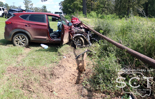
September 14, 2024 - State Highway 87 North was the scene of a single-vehicle crash near CR 1451 September 13, 2024.
According to Texas Department of Public Safety State Trooper Keith Jones, at 1:50pm a maroon 2020 Hyundai Tucson driven by Susan Elaine Young, 56, was southbound on State Highway 87 when, due to a medical emergency her passenger Mary Sue Steeley, 80, realized the Tucson was about to rear-end another vehicle and took evasive action grabbing the wheel and turning the vehicle off the roadway to the right. The vehicle exited the roadway, traveled over a culvert and struck a pipe fence owned by Gloria Barbee.
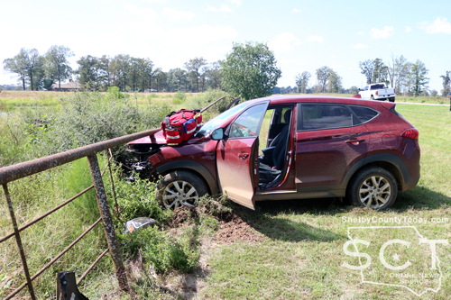
Young and Steeley were transported by ambulance to Shelby Emergency Department for treatment and observation.
No citations were issued at the time of the crash.

The Shelby County Commissioners held the inaugural meeting of the newly renovated Commissioner Courtroom on Wednesday September 4, 2024.
September 11, 2024 - The Shelby County Commissioner were updated during their September 4, 2024, meeting by Terry Allen on the continuing challenge to prevent a pit site being established in the Paxton Community, and the continuing battle with the Railroad Commission and the company trying to install the site.
“The Railroad Commission is only allowing 30 days for the comment period on these rules. These rules have not been changed in over two decades. New Mexico and Louisiana have a lot more stringent rules than Texas does and the Railroad Commission is proposing rules to be more lax in favor of the oil and gas company,” said Allen. “That’s largely to the detriment of the citizens of Texas.”
Allen asked the county commissioners to consider signing a letter he presented to them, or one similar, which propose four major changes to what the Railroad Commissioners are considering.
The changes Allen outlined included requiring land owner consent to ensure landowners are notified in advance and given the opportunity to grant permission or consent before any waste disposal occurs on the property to protect their rights and prevent unexpected environmental damage. This gives them the right to refuse on-site disposal since other more responsible disposal options exist.
Next, enhancing groundwater protection by mandating that reserve pits be lined equipped with leak detection and groundwater monitoring systems similar to standards used for commercial operations which prevent toxic chemicals from contaminating drinking water.
Implementation of waste management practices, adopt safer practices such as close loop systems which operators already successfully use in other states which minimize the environmental risk associated with oilfield waste disposal and protect our land and water.
He also said, going forward there should be greater setbacks for these oilfield waste disposal pits going to allow for adequate protection of people from pollution, water wells, and shallow aquifers.

“Right now, there’s only two scheduled hearings for comments on these rules and that’s tomorrow (Thursday, September 5) and Friday (September 6) in Austin at the Railroad Commission Building,” said Allen. “So they’re not allowing the citizens of Texas much time to digest all of these rule changes, proposed rule changes and to comment on them. In the past, when they last had the rule changes, they held six statewide meetings all over the state and I believe they allowed nine days for that period of comment.”
Allen says that’s all they are asking for is more time to allow for comment.
Allen stated when the Railroad Commission started the proposed changes, there was a committee, which he believes was made up of about 80 representatives of different industry and only two of the members were non-industry individuals. He says that after the first couple of meetings the non-industry individuals were no longer invited to the meetings.
Commissioner Roscoe McSwain asked Allen if he was attending the meeting in Austin; however, he could not due to a family medical concern.
“These four new rules you put in that you mentioned here I mean that’s common sense, if you don't protect your water, I mean, you got to put a differentiate value of oil and gas production to our economy to drinking water, drinking water is the last thing we want to lose,” said McSwain.

County Judge Allison Harbison mentioned the movie Erin Brockovich in relation to the concern over the potential hazard to the drinking water in Shelby County should the Railroad Commission allow the site in Shelby County.
“That was a true story that happened in California to do with groundwater, that was absolutely horrendous, and I mean, I don't want Texas to look like that. I don't want East Texas, I don't Shelby County to look like that,” said Judge Harbison.
Commissioner Tom Bellmyer recognized the property the company is trying to use is adjacent to Allen’s and that being why he is so passionate about this issue for the last four to five years and Bellmyer asked what the track record for the company is.
According to Allen, McBride Operating LLC has a “horrible” compliance record relating to other locations where the company exists.
“He’s contaminated both groundwater reservoirs where he operates facilities and he started contaminating them within 90 days of when he opened up his facilities,” said Allen. “They’re contaminated with chlorides, basically having consistency of seawater. His newest facility is contaminated with benzene, which is a highly carcinogenic chemical and it’s almost 12,000 times over the Texas water quality drinking standards. You see all these ads for Camp Lejeune being contaminated, the military drinking water, it’s 179 times over the water quality drinking standards.”
Allen says citations and fines are something familiar to McBride in addition to building unpermitted facilities.
“He’s been fined and cited and built unpermitted facilities, continues to operate. He tracks throughout the facility, contaminants wash off into existing property owners’ streams and Railroad Commission does not shut him down,” said Allen.

Allen elaborated further on a site in Waskom and then he turned pack to the Paxton site.
According to Allen, the Paxton facility is planned to include four pits with each one being approximately 60 feet in depth.
“When each pit gets full, they’re going to cover it with a membrane, then put two feet of topsoil on top of them,” said Allen. “They project it would take five to seven years to fill up the whole facility.”
The site would then be monitored for five years by McBride explained Allen, and then after that he says it would be abandoned.
“In our area we have hogs, armadillos, coyotes, pine tree roots, tallow tree roots, it’ll all penetrate that membrane and it’s going to allow contaminants to leak into surface and ground water,” said Allen. “I just wonder, you know, after five years are we on our own? It’ll be contaminating all our soil and water from now on.”
Allen describes a long process in the community trying to fight the facility moving into the area.
“We’ve been fighting this since Summer of 2019. McBride Operating LLC based in Longview sent in a permit request to the Railroad [Commission] for a solid waste disposal pit in Paxton Community right there on [U.S.] Highway 84 directly east of us and it’s less than 1,200 feet from the Paxton Water Supply system that serves around 700 families,” said Allen. “After the Railroad Commission gave him numerous extensions to make changes to his permit request, in December 19, 2019, we received a letter from the permitting department at the Railroad Commission that recommended denial of this permit for McBride Operating to create this solid water disposal.”
Allen explained some of the reasons given for the recommendation to deny the permitting was shallow groundwater places less than four feet, too great a slope, the soil type which is predominantly sand, streams, ponds, wetlands, public water wells and private water wells all located in close proximity to the site. According to Allen, the flow of the groundwater and the slope of the land go toward the east which includes Allen’s property and the Paxton Water Supply.
Allen said the Railroad Commission has a rule that with the denial of a permit from the permitting department, the company receiving the denial can request a hearing before the Railroad Commission.
“At the hearing, if the protesters don’t show up with their attorneys, with experts, all of their documentation, the permitting department has a permit issued and ready to hand to that operator to start operations,” said Allen.
Attorneys and experts were hired and attended the hearing, and Allen said the hearing lasted nine days, with two examiners.
“Several months later they issued their proposal for decision and it was to recommend denial for basically all the same reasons the permitting department did,” said Allen. “We go to a full-on Railroad Commission hearing with all three commissioners there and they voted to give him (McBride) a second chance and try to correct some problems.”
In May of 2023, Allen says there was another hearing that lasted three days and had four examiners, one of which was a geologist, which resulted in a 60-something page report with another recommendation for denial of the permit. According to Allen, the issue came back up on the Railroad Commission agenda for a vote and the commissioners passed on it due to needing more time to review. May 2024 it was on the agenda again, and Allen says the commission once again passed the item and said they needed more time.
Allen said they are looking for a “yes,” or a “no,” answer as he believes there is no reason for any further delay.
According to Allen, 70% of political donations to the Railroad Commissioners come from industry donors.
Commissioner Bellmyer has researched and what he described of the Railroad Commission is having some autonomy of the government and providing no real oversight of their charge in the oil and gas industry.
“They don’t actually, other than maybe the governor checking in with them,” said Bellmyer.
Allen responded, “the governor has no control over them.”
Commissioner Bellmyer stated the Railroad Commission employs 893 employees.
“You’ve got 890 people that work for them and it sounds as if there’s quite a large number of them saying this is not a good process,” said Bellmyer. “It appears to me that there’s somewhat of a stall by the three commissioners in hoping that one day someone won’t show up for a hearing and this thing will pass.”
The Railroad Commission budget, as stated by Commissioner Bellmyer, is $481 million for two years for a large organization with a lot of apparent influence.
“I looked at a number of the different organizations that they participate in and they do a lot of global activity,” said Bellmyer. “I’m a little frustrated with the whole thing.”
Commissioner Bellmyer remarked that included in the mission statement of the Railroad Commission are to protect the environment and protect the people of Texas.
“It should be the frustration of all the citizens of the county, especially since one of the commissioners lives in our county,” said Commissioner Bellmyer.
Commissioner McSwain asked Allen to name the Railroad Commissioners for those who may not know who they are and he stated they are Christy Craddick, Chairperson; Wayne Christian and Jim Wright.
“Senator Robert Nichols has been very protective and helpful on this matter in favor of the citizens of Paxton and also Travis Clardy,” said Allen. “Senator Nichols has met with the Railroad Commission several times and he’s really questioned them and recommended that they not do this. Then again, they have no oversight and the only oversight they have is the voters.”
Judge Harbison said that no one is a better proponent of the oil and gas industry than she is; however, not at the expense of the county’s natural resources.
“We’re going to be supplying water to other places one of these days if our water’s still potable,” said Judge Harbison.

Keith Duncan, Workforce Solutions Business Engagement Representative, for the Workforce Solutions office in Center and he interacts with employers.
"We have a program that the county participated in before, and it was ending when I first started," said Duncan. "The county did not have a business rep in the past and so I really have no past experience with this program, but we use the same agreement, the work-based learning agreement for this program and several others."
Duncan described several ways the commissioners can utilize workers for a variety of jobs.
"There are 20-something slots for all 12 counties, our office is going to have its fair share of them," said Duncan.
Duncan explained the program is fully subsidized and A.T. Staffing in Nacogdoches administers the program for Workforce Solutions.
The program has started and Duncan explained they are already trying to locate workers.
Commissioner Roscoe McSwain moved to engage in the Work-based learning agreement with Workforce Solutions and the motion was seconded by Commissioner Stevie Smith. The motion carried.
The commissioners considered a request from Tenaha City Mayor to allow Precinct 4 Commissioner Bellmyer to trim hedges and brush on two streets within the City of Tenaha with county equipment.
“I met with Mayor Jones yesterday and we rode the two streets that he had referenced to,” said Bellmyer. “There’s a little bit of brush to be cut, it’s predominantly the giant ragweed that’s growing that’s gotten so big this year.”
Bellmyer explained the cities boom mower is not functional and other neighboring cities are either overwhelmed with the same problem of overgrown weeds, or their equipment isn’t functional.
Commissioner Bellmyer moved to table the item for County Attorney John Price to draft an inter-local agreement, Commissioner Smith seconded the motion and it carried.
Commissioner Smith said he needs to add a load of rock for school bus turn around at CR 3801 on the outside of a curve.
Attorney Price stated an easement would be necessary.

Commissioner Smith moved to approve the load of rock for a school bus turnaround, pending an agreement with the landowner, and the motion received a second from Commissioner Bellmyer. The motion carried.
Commissioner Smith sought to extend CR 3427 to construct a turnaround.
“This is another problem with the school bus and also the other reason I need this turnaround is where I can get turned around my gravel trucks and a maintainer,” said Commissioner Smith.
After discussion, it was determined the area in question may have been previously been adopted by the county and further investigation by County Attorney Price would be necessary.
Commissioner Smith moved to table the item to allow Price to do a little title work, and the motion was seconded by Commissioner Bellmyer. The motion carried.
Bobby Daw, Shelby County Expo Center Manager, reported to the commissioners about how things are going at the Expo Center.
“Our season’s over with except for October 5, which is Poultry Festival, they’ll be judging our chickens out there,” said Daw. “We’ve had a good year, everything’s done we didn’t have a mule riding this year.”
He said there was a circus on the grounds this year and it was full and well attended.

Daw explained dirt work is necessary in the arena and he said they would need help moving some dirt. The next project they are looking at getting done is a new announcer’s booth.
Last year 50 Women of Impact donated to the Shelby County Expo Center and Daw said that money was set aside then for dirt work in the arena.
Commissioner McSwain moved to approve the donations the organization has received and move forward on upgrade of the arena, the motion was seconded by Commissioner Smith and it carried.
Judge Harbison opened bids for Sheriff’s Department vehicles and Commissioner McSwain moved to accept the bid from San Augustine Motor Company of $182,024.64. The motion was seconded by Commissioner Smith and it carried.
Commissioner Bellmyer moved to approve a resolution and agreement to close CR 4188, and the motion was seconded by Commissioner Smith. The motion carried.
Agenda items approved during the meeting include:
1. Weekly expenses.
2. Accept donations for upgrades to the Shelby County Expo Center Facility.
3. Award bid to San Augustine Motor Company for Sheriff’s Department vehicles.
4. Resolution and agreement to close CR 4188.
5. Work Based Learning Agreement with Workforce Solutions.
6. Time change for the Sept 11th, 2024 Regular Commissioners Court meeting from 9:30 AM to 10:30am.
7. Christmas Committee to donate Christmas wreaths and hangers for the windows of the Historic Courthouse.
8. Request from Tenaha City Mayor to allow PCT 4 Commissioner to trim hedges and brush on two streets within the City of Tenaha with county equipment.
9. Allow the Ag Mechanics Organizers to utilize the back awning of the Courthouse on the evening of Wednesday, October 2, 2024.
10. Adjourn at 10:53am.

Agenda items tabled during the meeting include:
1. Discuss and possibly approve one load of rock for school bus turn around at CR 3801.
2. Discuss and possibly approve extending CR 3427 to construct a turn around.
Related Articles:
- RRC Extends Comment Period on Amendments to Chapter 3, Chapter 4 Rules Relating to Waste Management
- Commissioners' Court Seeks JP Pct. 4 Candidates; Passes Resolution Regarding Oil, Gas Industry
- Company that wants to build oilfield dump in East Texas gave $53,750 in campaign donations to regulators (Texas Tribune)
- For Texans, fighting state-regulated oilfield waste dumps can be a costly, do-it-yourself effort (Texas Tribune)
- Waskom landowners detail concerns, two-year battle over oilfield waste site (The Marshall News Messenger)
- Company that wants to build oilfield dump in East Texas gave $53,750 in campaign donations to regulators (KSAT)
Pages