

The story headline links to a better view of the story and share features.


News
July 19, 2024 - The City Council adopted animal control ordinances most recently in 1998 to assist in stray animal population control, state rabies regulations and dangerous dog sections of State law. The Center Police Department is responsible for enforcing those ordinances and responding to animal complaints including nuisances and dangerous animal situations.
Due to the exhibited and unacceptable conditions of the holding facility Tuesday via social media, the Center Police Department was directed Tuesday evening by the City to suspend activities for animal control capture or impoundment until the situation was resolved and adjustment to procedures for alternative approaches to enforcement can be presented and reviewed. The Center Police Department participated with investigation of conditions from holding of stray and abandoned animals and initiated action to address animals on site.
The facility is on City property, not operated by the City but has been allowed to be utilized as a temporary holding facility by individuals providing contract services as a vendor for animal control activities. Subsequently, the contracted vendors providing services were charged for the conditions at the site. The animals that remained at the holding facility were either rehomed or have been scheduled to be sheltered. The site will be vacant and unavailable for any use. Actions were taken to address the unacceptable conditions while initiating administrative review of this situation and related operations. This matter remains under continued investigation.
The Center Police Department will not be responding to any abandoned or stray animal complaints during this period but will respond to emergency situations. State and local laws will be reviewed or amended by City Council as appropriate and a thorough examination of alternative approaches to enforcement of those revised statutes will be evaluated including anticipated partnerships with potential or existing animal shelter operations.

Updated: As of 12:45 the repair to this main was completed and system pressure should begin to return to normal conditions.
July 19, 2024 - The City of Center reports a utility company making installation on Hwy 7 has damaged the largest water carrying main in town. Crews are responding and attempting to isolate areas of the water system to be able to initiate repairs that will be substantial. Outages should be anticipated in the area of Nacogdoches Highway from Hurst St and Loop 500.

July 18, 2024 - A Shelby County Grand Jury handed down 23 indictments on Wednesday, July 16, 2024. The grand jury was impaneled for the July 2024 term of the 123rd/273rd Judicial District Courts. Five of the indictments were for James Alan Burke, the target of an undercover investigation of online solicitation of a minor that resulted in his arrest on March 3, 2023. (Child Predator Undercover Operation Catches Timpson Man).
Stacey Buford Wells was indicted for injury to a child, elderly individual, or disabled individual, third degree felony. The indictment alleges, on May 28, 2024, Wells caused bodily injury to Kathey Tuckers, an individual 65 years of age or older, by hitting, scratching, and biting her repeatedly. (273rd Judicial District Court)
David L. Godwin was indicted for unlawful carry weapon with felony conviction, second degree felony. The indictment alleges, on November 22, 2023, Godwin recklessly carried a handgun on or about his own person while not on his own premises or premises controlled by him, or while en-route to a motor vehicle or watercraft that he owned. The indictment further states, Godwin was prohibited from possessing a firearm at that time due to a previous felony conviction for possession of a controlled substance and possession with intent to deliver on November 22, 2023. (123rd Judicial District Court)
Armando Javier Huerta was indicted for engaging in organized criminal activity, first degree felony. The indictment alleges, on April 8, 2024, Huerta with intent to establish, maintain, or participate in a combination or in the profits of a combination consisting of Huerta, Ricardo Rodrigues, Jonathan Vincente, Marlena Poore and an unknown man, who collaborated in carrying on the hereinafter described criminal activity. The indictment further alleges conspiracy to commit the offense of unlawful possession with intent to deliver a controlled substance or dangerous drug, in possession of stolen property and weapons by agreeing with each other that they would engage in conduct that constituted the offense, and Huerta, Rodriguez, Vincente, Poore, and unknown man, performed an overt act in pursuance of the agreement, namely, unlawful possession of stolen property and weapons. (273rd Judicial District Court)
(Some of the following content contained within indictments is of a sensitive nature and may not be suitable for younger viewers.)
James Alan Burke was indicted for possession with intent to promote child pornography with a previous conviction, first degree felony. The indictment alleges, on December 21, 2022, Burke possessed with intent to promote visual material that visually depicted, and that Burke knew visually depicted, a child who was younger than 18 years of age at the time the image of the child was made, engaging in sexual conduct, namely actual deviate sexual intercourse. Prior to the commission of foresaid offense, on October 30, 2024, in Sebastian County, Arkansas, Burke was convicted of 4th Degree Sexual Assault. (273rd Judicial District Court)
James Alan Burke was indicted for possession with intent to promote child pornography with a previous conviction, first degree felony. The indictment alleges, on December 21, 2022, Burke possessed with intent to promote visual material that visually depicted, and that Burke knew visually depicted, a child who was younger than 18 years of age at the time the image of the child was made, engaging in sexual conduct, namely actual lewd exhibition of the genitals. Prior to the commission of foresaid offense, on October 30, 2024, in Sebastian County, Arkansas, Burke was convicted of 4th Degree Sexual Assault. (273rd Judicial District Court)
James Alan Burke was indicted for possession with intent to promote child pornography with a previous conviction, first degree felony. The indictment alleges, on December 21, 2022, Burke possessed with intent to promote visual material that visually depicted, and that Burke knew visually depicted, a child who was younger than 18 years of age at the time the image of the child was made, engaging in sexual conduct, namely actual sexual intercourse. Prior to the commission of foresaid offense, on October 30, 2024, in Sebastian County, Arkansas, Burke was convicted of 4th Degree Sexual Assault. (273rd Judicial District Court)
James Alan Burke was indicted for possession with intent to promote child pornography with a previous conviction, first degree felony. The indictment alleges, on December 21, 2022, Burke possessed with intent to promote visual material that visually depicted, and that Burke knew visually depicted, a child who was younger than 18 years of age at the time the image of the child was made, engaging in sexual conduct, namely actual sexual intercourse. Prior to the commission of foresaid offense, on October 30, 2024, in Sebastian County, Arkansas, Burke was convicted of 4th Degree Sexual Assault. (273rd Judicial District Court)
James Alan Burke was indicted for possession with intent to promote child pornography with a previous conviction, first degree felony. The indictment alleges, on December 21, 2022, Burke possessed with intent to promote visual material that visually depicted, and that Burke knew visually depicted, a child who was younger than 18 years of age at the time the image of the child was made, engaging in sexual conduct, namely actual sexual intercourse. Prior to the commission of foresaid offense, on October 30, 2024, in Sebastian County, Arkansas, Burke was convicted of 4th Degree Sexual Assault. (273rd Judicial District Court)
(Dates in parenthesis indicate the date of the alleged incident):
- Michael Dewayne Watts, possession of a controlled substance PG1/1-B >=1G<4G (phencyclidine), third degree felony (January 29, 2024). (273rd Judicial District Court)
- Michael Ray Foxworth, possession of a controlled substance PG1/1-B >=4G<200G (methamphetamine), second degree felony (February 18, 2024). (123rd Judicial District Court)
- Joel B. Fleming, possession of a controlled substance PG1/1-B >=1G<4G (methamphetamine), third degree felony (March 17, 2024). (273rd Judicial District Court)
- Esteban Lucio-Melendez, possession of a controlled substance PG1/1-B <1G (methamphetamine), state jail felony (April 22, 2024). (123rd Judicial District Court)
- Destinee Berana Adams, possession of a controlled substance PG1/1-B <1G (methamphetamine), state jail felony (April 2, 2024). (273rd Judicial District Court)
- Johnny Ray Green, possession of a controlled substance PG1/1-B >=1G<4G (methamphetamine), third degree felony (April 15, 2024). (123rd Judicial District Court)
- Brent Howard Denby, possession of a controlled substance PG1/1-B >=4G<200G (methamphetamine), second degree felony (May 23, 2024). (273rd Judicial District Court)
- Kenneth Grimes, prohibited substance in a correctional facility (methamphetamine), third degree felony (February 8, 2024). (123rd Judicial District Court)
- Elizabeth Christine Fanning, possession of a controlled substance PG1/1-B >=4G<200G (methamphetamine), second degree felony (February 18, 2024). (273rd Judicial District Court)
- Michael Aaron Robinson, possession of a controlled substance PG1/1-B <1G (methamphetamine), state jail felony (January 19, 2024). (273rd Judicial District Court)
- Dennis Keith Mann, possession of a controlled substance PG1/1-B >=1G<4G (cocaine), third degree felony (April 3, 2024). (123rd Judicial District Court)
- Stephanie Michelle Jackson, possession of a controlled substance PG1/1-B >=1G<4G (phencyclidine), third degree felony (January 29, 2024). (123rd Judicial District Court)
- Armando Javier Huerta, possession of a controlled substance PG1/1-B >=4G<200G (methamphetamine), second degree felony (April 8, 2024). (273rd Judicial District Court)
- Derek Wayne Hendricks, possession of a controlled substance PG1/1-B >=4G<200G (methamphetamine), second degree felony (March 13, 2024). (123rd Judicial District Court)
- Dmarco Kevon Johnson, possession of a controlled substance PG1/1-B >=4G<200G (psilocin), second degree felony (March 3, 2024). (273rd Judicial District Court)
Indictments and Information are not a conviction, and are a matter of public record. All individuals are presumed innocent until found guilty in a court of law.


July 18, 2024 - Shelby County Sheriff Kevin W. Windham reports the arrests of Robert Lindley, 39, of Center and Christal Gayle Lindley, 44, of Center.
On July 17, 2024, Sheriff Windham was informed of a dog kennel, operated by the City of Center, and maintained by the Lindley’s, to be housing dogs in unsuitable living conditions.
An investigation by the Shelby County Sheriff’s Office revealed at least one animal has died at the facility. Investigators noted that most of the animals housed at the kennel appeared to have mange and be malnourished. The kennel was not provided with adequate air flow.
The Lindley’s were arrested and charged with Cruelty to Non-Livestock Animals (M-A). They are currently housed in the Shelby County Jail.


The dog pictured above was returned to its owner on July 17 and the one on the left is depicted as before being picked up and the one on the right is after being returned. (Photos Courtesy Stephanie Snell)
One dog was removed from the facility and returned to its rightful owner. Approximately 14 dogs are being released to Nicolas Pet Haven, an animal rescue organization out of Tyler, at the approval of County Attorney John Price. The animals will be treated for their conditions and placed up for adoption.
This is an ongoing investigation. No further information will be released at this time.
Leah Chase, SCSO

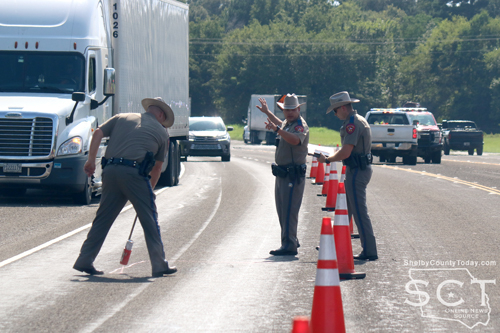
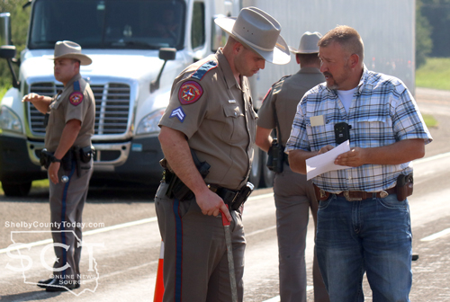
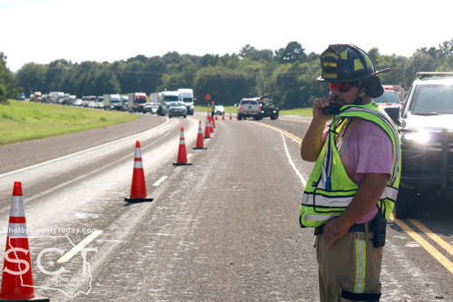
July 18, 2024 - Emergency personnel responded to a major cash incident just outside of Tenaha on U.S. Highway 59 Wednesday, July 17, 2024, at 3:48pm.
The crash involved an 18-wheeler and a passenger car, which had multiple occupants, approximately a mile-and-a-half from Tenaha. Tenaha Volunteer Fire Department was dispatched to the scene and Timpson Volunteer Fire Department arrived at the location to assist.

Airlift was requested to the location; however, air support was not able to fly at that time. Texas Department of Public Safety (DPS) State Troopers from Nacogdoches were dispatched to the scene to assist Shelby County Troopers.
According to information from the Texas DPS, the preliminary crash investigation indicates that a Mack truck tractor semi-trailer driven by Zachary Perez, 41, of Marshall was traveling northeast in the outside lane, followed by a Dodge Journey driven by Jonathan Toledo, 22, of Nacogdoches. It is reported that Toledo failed to control his speed and struck the rear of the semi-trailer.

Toledo, and two passengers, a 17-year-old female and a 5-year-old male child, were transported to Nacogdoches Medical Center by ambulance for treatment of non-life-threatening injuries.
A 6-year-old female child was transported by ambulance to Nacogdoches Medical Center for treatment of life-threatening injuries.

Perez was not reported to have been injured.
Toledo was cited for failing to control his speed and for failing to properly secure a child with a child safety seat.
According to DPS, this is an ongoing investigation, and no further information is available.
Shelby County Sheriff's Department deputies and Josh Tipton, Constable Precinct 5; as well as Taylor Fanguy, Constable Precinct 4; were on scene to assist DPS with their investigation.
DPS Troopers from Nacogdoches investigating the scene were Cpl. Trooper Austin Lunsford; Trooper Herbert Flores; Trooper Kody Moore; and Trooper Brinden Stephens. Shelby County Trooper at the scene was Daniel Dellenger.


July 17, 2024 - Agenda Item for Legalizing Sale of Alcohol Removed From Timpson’s July Meeting
Recently Kyle Edwards petitioned to legalize the sale of alcohol, including mixed drinks, inside the city limits of Timpson. As many of you know there is a process to get this from idea to ballot. Kyle Edwards followed all of the guidelines shared with him at the onset of this process. It was his intention to have this before the city council at the regular July meeting. The agenda item had to be stricken from the agenda due to a timeline issue. From the time the initial 10 names are gathered for the application to getting the petition from city hall isn’t really a timed event; however, the next few steps are very much governed by exact timelines and dates.
Once the petition was picked up from City Hall to get the 76-plus names, the persons gathering signatures had 60 days to get them turned in to City Hall. Then the city secretary has five days to get the names verified and the petition submitted to SOS (Secretary of State). The matter then had to be presented as a Resolution for the city council to approve at a regular meeting At Least 30 days following the submission of the petition to City Hall. This 30-day period is specifically set out in the resolution and is why this matter was removed from the July 2024 regular meeting agenda. Kyle Edwards submitted more than enough names on the aforementioned petition to Misty Burgess on July 1, 2024 to be placed on the November 5, 2024 ballot. Mrs. Burgess realized when putting the information into the required Resolution template that it had not been 30 days since the names had been submitted to her. She called the SOS and the city’s attorney and was advised to strike it and have the petitioner start the process over. It was also determined that the item could not be moved to the August 2024 meeting due to the 78-day guideline that is required between council meeting and election.
Unfortunately, the next election isn’t until May 3, 2025. Therefore, in late September, the process will start again. Kyle and the people assisting him will reach out to the signers of the first application around Oct 3. The application will be turned into City Secretary, Misty Burgess around Oct 11. All signatures (76-90 names) will have to be gathered by December 10, examined and submitted to SOS by Dec 15. Following these steps a Resolution will be presented at the January 21, 2025 regular city council meeting to have the item on the May 3, 2025 city election ballot. These steps are necessary to have this matter on the ballot. The petitioners will be moving ahead with their petition and apologize for any inconvenience due to this delay.
Related Article:
Timpson City Council Regular Meeting Minutes, July 16

Hassan Awels
July 16, 2024 - The Center Police Department has confirmed a shooting incident took place in Pecan Grove on July 11, 2024.
Center Police Officers responded to the scene a couple blocks from the Center Police Department, and were assisted by Shelby County Sheriff’s Department deputies.
In a press release issued by the Center Police Department, it's indicated their Communications Division received a call at 11:24pm, about harassment. While the caller was on the line with the Communications officer, the caller stated that the suspect began shooting at them. The Center Police Department Patrol Division was dispatched to the area of Pecan Grove in the 1300 block of Shelbyville Street.
When Officers arrived on the scene, they found a vehicle that had been struck by gunfire approximately four times. The victims, identified as Ricardo Cervantes and Maria Juarez, were determined not to have been struck by any of the shots.
According to the Center Police Department, Cervantes informed officers he struck another vehicle with his in Pecan Grove when trying to flee after the shooting started.
Just before the officers arrived on scene, the suspects fled the scene, and the Center Police Department confirms the suspects were later identified as Hassan Awels, 21, of Center and Abdulkadi Abu, 48, of Center.
Awels and Abu were both arrested and transported to the Shelby County Jail where they were each booked on charges of aggravated assault with a deadly weapon, felony 2.
The press release goes on to state this was an isolated incident, and no further risk of harm is believed to be present to the public. This remains an active case and no further information is available at this time.
According to the Shelby County Jail log, the charges against Abu were dropped.
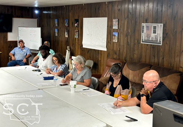
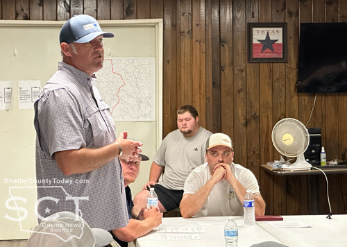
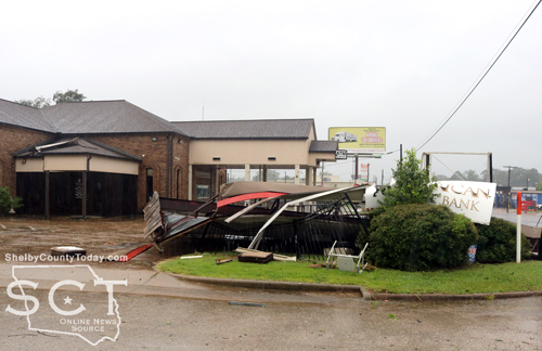
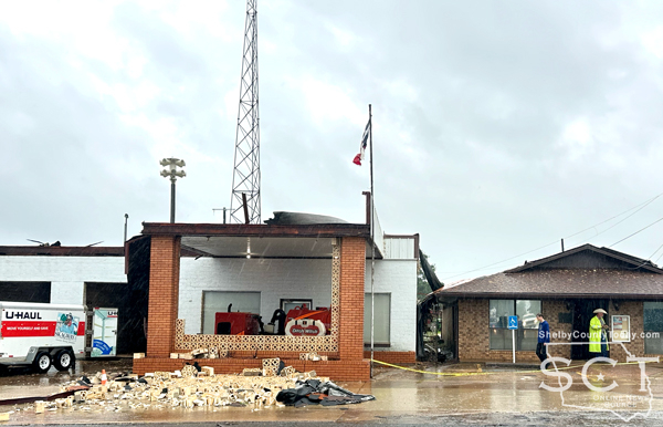
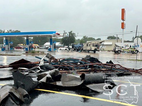
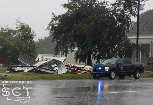
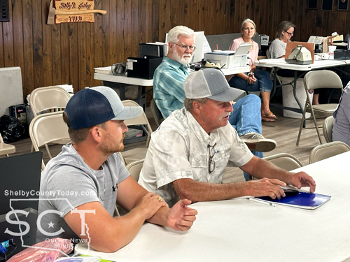
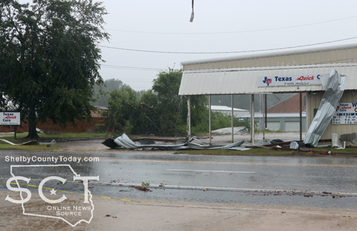
July 14, 2024 - Timpson City Council held an emergency meeting Friday, July 12, 2024, at 4pm in the Volunteer Fire Department fire hall due to the damage incurred at the city building during Tropical Storm Beryl.
Mayor Debra Smith opened the meeting and the council considered and first approved the authorization of business operations of City Hall to be temporarily moved to 305 Jacob St., including public meetings.

Council member Judd “Tuffy” Green moved to approve the authorization with council member Terri Alexander seconding the motion and it carried.
Mayor Smith thanked the fire department for allowing the city to utilize their fire hall.

Shelby County recently issued a disaster declaration, and the council agreed to amend the declaration issued by the county and apply “City of Timpson” for use to submit to the state.
Council member Terri Alexander moved to amend the declaration to include the city’s complications, and her motion was seconded by council member Penny Ramsey. The motion carried.
The council discussed the emergency purchase of a wireless/radio float system to regain full functionality of the water tower. The current hardwire system is cut in multiple places causing the city to have to manually fill the water tower.
Larry Burns, Public Works, explained they are having to fill the water tower every four hours and it’s around 1,500 feet from the pump house to the water tower. Burns said the wire isn’t very effective as it’s been torn down by trucks over the years and a wireless system would be more beneficial.

Mayor Smith presented a quote from Lonestar Global in the amount of $13,500 to be paid out of the water department.
Council member Alexander moved to make the purchase, and the motion was seconded by council member Ramsey. The motion carried.
Mayor Smith inquired how long it would be before the system would be installed and Burns said it would be seven days out.
Ryan Knight addressed the council and explained the city if Timpson is insured through Texas Municipal League (TML) Incident Risk Pool and with that there is a specific benefit just to TML members called the “Turn Key Recovery Program,” which is implemented by Synergy which Knight represents.
“What we do is we basically take this as an example of what's going on with this tornado. We get the community back up and running as quickly and efficiently as possible. While the city focus on their people and their tasks, we'll take care of all of the other other stuff. There is no cost to the city for the services. It's a specific benefit for TML members,” said Knight.
Knight said the only thing that the city would be liable for is the deductible, which is standard, and the benefit includes the entire build back.
To discuss and take action authorizing the mayor, Larry Burns, and Misty Burgess to work with Synergy and TML to complete any claims, authorize emergency purchases, and enter into the bid process for completing the renovation of City Hall
Council member Alexander moved to approve Mayor Smith, Larry Burns and Misty Burgess to help complete any claims and authorize emergency purchases. The motion was seconded by council member Green and the motion carried.

One of the last items for the council to consider was taking the necessary steps for an approved vendor to be accepted to handle debris removal pursuant to the emergency declaration and TDEM steps on debris removal.
“So I'm guessing this the way this is going to work is that you allow me and Larry to work with TCEQ and emergency management to see what the process is to select a vendor to do this and if it's something that they have to submit bids or whatever, we'll have to have another meeting,” said Mayor Smith.
Mayor Smith said what she understood to be the first step is to have to find a site they can take the debris to burn because the Texas government has decided wood from one location to another, even if it’s a very close distance, could be unsafe somehow.
Not only would city representatives have to approve a site, the county judge, emergency management and Texas Commission on Environmental Quality, would also have to approve a site.
Discussion covered how much acreage might be needed to burn to the possibility if any of it could be used for fire wood in the future.
Council member Alexander moved to give Mayor Smith the authority to take the necessary steps to handle debris removal. The motion was seconded by council member Ramsey and the motion carried.
Mayor Smith explained that a business owner provided a portable building for the city to use for four months at no charge until repairs could be accomplished in the city.
Council member Alexander moved to purchase the building after the four month time period in the amount of $6,997.25. The motion was seconded by council member Ramsey and the motion carried.
The meeting adjourned at 4:35pm.

Agenda items approved during the meeting include:
1. Declaration of Emergency for City of Timpson
2. Emergency purchase of wireless/radio float system to regain full functionality of the water tower. Currently hardwire system is cut in multiple places causing us to manually fill the water tower.
3. Authorize the mayor, Larry Burns, and Misty Burgess to work with Synergy and TML to complete any claims, authorize emergency purchases, and enter into the bid process for completing the renovation of City Hall.
4. Take the necessary steps for an approved vendor to be accepted to handle debris removal pursuant to the emergency declaration and TDEM steps On debris removal.
5. Authorize the business operations of City Hall to be Temporarily moved to 305 Jacob St, including public meetings.
6. Any other emergency items - Purchase portable building after the four month loan time period in the amount of $6,997.25
7. Adjourn - 4:35pm.
Agenda items tabled during the meeting include:
1. Discuss and take action on the possible demolition of the building that housed the Police Dept, the storage room, and equipment bays with the agreement to accept ACV From TML.
July 12, 2024 - Timpson Mayor Debra Smith announces that Timpson now has power restored in all sectors as of Friday evening, July 12.
July 10, 2024 - Due to the damage incurred by Hurricane Beryl to the City of Timpson City Hall, an alternate office location is being established, as well as temporary office hours.
Below is a schedule of when Paula Davis Mullins and Misty Miller Burgess will be conducting Limited Business at Timpson Volunteer Fire Department until a temporary office is delivered and set up. The office will be closed July 10-11.
Thank you for your patience. Mayor Debra Smith
Temporary Office Hours
Timpson City Hall at TVFD
305 Jacob Street
- Friday, July 12 - 10-4
- Saturday, July 13 - 10-2
- Monday, July 15 - 9-3
No Pink Notices
*waive late fee
- Tuesday, July 16 - 9-3
- Wednesday, July 17 - 9-3
- Thursday, July 18 - 9-3
- Friday, July 19 - 8-4
Due to the damage incurred by Hurricane Beryl to the City of Timpson City Hall, an alternate office location is being established, as well as temporary office hours.
Below is a schedule of when Paula Davis Mullins and Misty Miller Burgess will be conducting Limited Business at Timpson Volunteer Fire Department until a temporary office is delivered and set up. The office will be closed July 10-11.
Thank you for your patience. Mayor Debra Smith
Temporary Office Hours
Timpson City Hall at TVFD
305 Jacob Street
- Friday, July 12 - 10-4
- Saturday, July 13 - 10-2
- Monday, July 15 - 9-3
No Pink Notices
*waive late fee
- Tuesday, July 16 - 9-3
- Wednesday, July 17 - 9-3
- Thursday, July 18 - 9-3
- Friday, July 19 - 8-4
Last day before Cut-Off
** Monday July 22 9-5*
Tuesday July 23 8-4
*unpaid accounts will be cut off starting at 10am
** Monday July 22 9-5*
** Tuesday July 23 8-4
*unpaid accounts will be cut off starting at 10am
July 11, 2024 - Solid Waste Dumpsters are available in each Precinct within Shelby County. This service is provided free to the residents in each Precinct as a courtesy. However, it has come to our attention that restricted items are being placed in the dumpsters. Restricted items consist of personal household trash, tires, paint, oil, and batteries.
The improper use of the dumpsters leads to problems with hazardous waste and excessive waste. If the problems keep occurring, we will have no choice but to discontinue this service to the residents in each Precinct.
Pages