

The story headline links to a better view of the story and share features.


News
March 25, 2024 - Wind advisory in effect from 10am this morning to 7pm CDT this evening.
This Hazardous Weather Outlook is for south central and southwest Arkansas, for north central and northwest Louisiana, and for deep east Texas and portions of northeast Texas.
Day One - Today and tonight:
Please listen to NOAA Weather Radio or go to weather.gov on the Internet for more information about the Wind Advisory.
Days Two Through Seven - Tuesday through Sunday:
A Slight to Enhanced Risk for severe storms remains for the ArkLaTex as the ongoing line of developing thunderstorms moves across I-30 this morning. The daytime heating on will boost the potential for severe thunderstorms in the line during the afternoon over deep east Texas, southern Arkansas and northern Louisiana. We can expect that any strong to severe storms will have the potential to bring down damaging winds, a few tornadoes, large hail and brief locally heavy rainfall.
Days Two Through Seven - Tuesday through Sunday:
The rest of the week is looking very nice and warm aside from a few more showers late on Wednesday for eastern Texas under the parent upper trough. The weekend will be partly cloudy and even warmer with low to mid 80s for high temperatures. No hazardous weather is expected at this time.
Spotter Information Statement:
Spotter activation will likely be needed.
Counties included are: Sevier, Howard, Little River, Hempstead, Nevada, Miller, Lafayette, Columbia, Union, Caddo, Bossier, Webster, Claiborne, Lincoln, De Soto, Red River, Bienville, Jackson, Ouachita, Sabine, Natchitoches, Winn, Grant, Caldwell, La Salle, Bowie, Cass, Marion, Harrison, Panola, Shelby, San Augustine.
March 22, 2024 - Shelby County has received an allocation from the American Rescue Plan Act (ARPA) Funds from the U.S. Department of Treasury and has elected to use these funds to complete eligible projects. This solicitation is for one 1.5 ton F550 or equivalent single cab truck with 11ft steel bed flatbed. The solicitation may be provided when requested via e-mail to the address below. Bids must be received no later than March 25, 2024, 12:00 PM. Please submit your sealed bid, including 1 marked original(s) and 2 copies to Ann Blackwell, County Treasurer, 200 San Augustine St Box 5 Center, TX 75935, and email to: ann.blackwell@co.shelby.tx.us.
It is the responsibility of the submitting firm to ensure that the bid is received in a timely manner. Submissions not received by the specified date and time will be rejected. The County reserves the right to negotiate with any and all individuals or firms that submit bids and may award a contract to multiple service provider(s). Residents and Businesses, Minority Business Enterprises, Small Business Enterprises, Women Business Enterprises, United States Veterans and Labor Surplus Area firms are encouraged to submit proposals. Shelby County is an Affirmative Action/Equal Opportunity Employer.
March 21, 2024 - Shelby County Jail inmates being housed in Panola County continue to be a heavy expense to the county and Shelby County Commissioners were informed of the continuing monthly expenditure during their March 13, 2024 meeting.
Ann Blackwell reviewed some of the bills with the commissioners as she gave the officers’ report, with a very notable expense being for Shelby County prisoners housed in Panola County at a total of $26,450 for the month from February 1 to February 29, 2024.
Another expense she highlighted was one for $17,583.78 to Motorola Solutions, Inc. for regular annual maintenance to the Spielman program for the Sheriff’s Department.
Commissioner Tom Bellmyer stated, “Looks like we've got a pretty good bill to Panola County, we’ve got several folks housed there now?”
Blackwell confirmed there are more than several being housed in Panola County.
“We do, and he has, and I believe that he's brought all he can back to the jail. The jail is full, I believe,” said County Judge Allison Harbison.
Commissioner Roscoe McSwain moved to approve the weekly expenses, and the motion was seconded by Commissioner Jimmy Lout, the motion carried.
During Blackwell’s financial report to the commissioners, she reported the American Rescue Plan Act (ARPA) fund expenses for February leading up to March was $283,097.88 and leaving an ending balance at that time of $1,941,110.87.
The Local Assistance Tribal Consistency Fund (LATCF) expenses for the same time period as previously referenced were $26,543.26, leaving an ending balance for the fund of $191,076.64.
Blackwell referenced worksheets provided to the commissioners relating to the LATCF and ARPA funds. This includes the new trucks the commissioners are planning on using ARPA funds to purchase, and the potential price tag on those referenced at the previous meeting ranged from $180,000 each to $250,000 each. This would potentially be a $720,000 to $1 million expense.
A fence, at a cost of $10,000, at the Jackson Paxton Water Supply well project was all Blackwell says remains on that project. An update on Huber water well is also anticipated.
Blackwell stated the election equipment project is completed and the projects for AgriLife and the gym have been removed from the list.
According to Blackwell, the fund balance including the estimated trucks for the commissioner precincts, would be $603,271.27.
Commissioner Bellmyer moved to approve the officers’ report and the motion was seconded by Commissioner Lout, and the motion carried.
The meeting adjourned to executive session at 9:46am and returned to open session at 10:24am
Commissioner Bellmyer explained, one of the items the court discussed during executive session was a piece of property adjacent to the precinct four barn.
Commissioner Bellmyer moved to move forward with the condemnation process on that property and go out for an appraisal with an independent appraiser for the value of that property. Commissioner Stevie Smith seconded the motion, and it carried.
Commissioner Roscoe McSwain sought approval to purchase sand from Darin Borders for the pugmill. He stated it was discussed in the past by the court that they were going to purchase sand somewhere in Joaquin this year for temporary use and then move around if we needed.
“That sand did not test out to be usable for the pugmill. So I've moved to a different location in Precinct 1 off of Highway 96 South, close to where the mills been, and done soil samples of an open field that have no trace, nothing to remove, said Commissioner McSwain.
He stated that land is owned by Mr. Darin Borders with a good oil field road access to the property already in place.
Commissioner McSwain said he would like to have the project locked down for a two-year contract.
Commissioner McSwain made a motion to move forward with getting a contract together and the motion was seconded by Commissioner Lout, the motion carried.
The commissioners considered the purchase a license at a yearly cost of $3,000 for the Guardify Program for storage and access to forensic interviews performed at the CAC for the benefit of the District Attorney and District Courts.
Judge Harbison said the program transcribes interviews and Karren Price, District Attorney, said to her it would be invaluable for her office in their work.
Commissioner Bellmyer moved to purchase the software license as requested at a yearly cost of $3,000, out of the District Attorney budget, and the motion was seconded by Commissioner McSwain. The motion carried.
Judge Harbison said there is someone that has agreed to do temporary custodian work two to three days a week. And whenever we do open the bids for the bid packets and everything and set a date for a new custodian to work, she's just agreed to work until that time.
“She has worked with the previous custodian in the past, and I think she'd be a really good fit,” said Judge Harbison.
Commissioner Bellmyer moved to enter into an agreement with the person through a contract for $2,400 a month County Attorney John Price has put together, and the motion was seconded by Commissioner McSwain. The motion carried.
“My secretary has asked to go on a part-time. She would like to keep indigent health care and be the website coordinator,” said Judge Harbison.
Judge Harbison confirmed it’s probably not more than 20 hours a week, and that it’s an hourly position.
Commissioner Bellmyer moved to approve the indigent health care coordinator and website administrator on a part-time basis and set the rate of pay at its current rate. Commissioner Lout seconded the motion and it carried.
“Just as a matter of policy, as a point of reference, we have a pay scale at the [Sheriff’s Office], and it has a starting rate and an ending rate,” said Clint Porterfield, County Auditor. “We've also done this in a couple of other situations, where a person goes from full-time to part-time, they usually give up first of all their benefits. And then they usually go back to the starting pay rate of that position or the starting pay rate or the base rate. That’s all I want to say.”
Commissioner Bellmyer explained his position on the pay, “I guess for me, I understand looking at a part-time individual and full-time individuals, but to have a person that is going back to part-time from a full-time position, you have a certain amount of training and experience that you're paying for.”
Porterfield said it’s no different than any of the other positions.
The motion carried.
“I would like to hire an administrative assistant and set the pay rate at the $14, which is the beginning rate of clerical for courthouse,” said Judge Harbison.
Commissioner Lout moved for Judge Harbison to hire an administrative assistant, and the motion was seconded by Commissioner Bellmyer. The motion carried.
The meeting adjourned at 10:39am
Officers’ reports for the month of February as presented by Ann Blackwell, County Treasurer:
Fees for the month of February 2024
- Debora Riley, Tax Assessor Collector - Property: $1,602,617.12; Motor Vehicle: $207,777.47; Total: $1,810,394.59
- Jennifer Fountain, County Clerk - $38,429.04
- Lori Oliver, District Clerk - $14,307.30
- Donna Hughes, JP1 - $21,112.00
- Marla Denby, JP2 - $927
- Melba Rodgers, JP3 - $3,246.00
- Dee Dee Green, JP4 - $5,098.70
- Tracy Broadway, JP5 - $10,406.65
- Zack Warr, Constable 1 - $1,060.00
- James Hagler, Constable 2 - $90.00
- Roy Cheatwood, Constable 3 - $250.00
- Taylor Fanguy, Constable 4 - $91.00
- Josh Tipton, Constable 5 - $450.00
- Sheriff’s Fees - $795.00
- Total of $1,906,657.28
Total investments of $20,524,881.52
Total interest earned on investments of $92,184.79
Agenda items approved during the meeting include:
1. Minutes of February 7, 2024 Special meeting, February 14, 2024 Regular meeting, February 21, 2024 Special meeting, February 28, 2024 Special meeting, of the Shelby County Commissioner’s Court.
2. Pay weekly expenses.
3. Pay current Payroll.
4. Officers Report.
5. Move forward with the condemnation process on a property beside the Precinct 4 barn and go out for an appraisal with an independent appraiser for the value of that property.
6. Commissioner Pct. 1 to purchase sand from Darin Borders for the Pugmill.
7. Purchase a license at a yearly cost of $3,000 for the Guardify Program for storage and access to forensic interviews performed at the CAC for the benefit of the District Attorney and District Courts.
8. Compensation for the temporary custodian of $2,400 a month and set a pay rate and requirements.
9. Allow the Indigent Health Coordinator to move to a part-time position and set the rate of pay at the “current pay rate.”
10. Allow the County Judge to hire an Administrative Assistant and set the rate of pay at $14 an hour.
11. Adjourn at 10:39am.

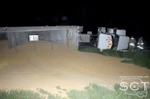
March 20, 2024 - SL 500 was the scene of a single-vehicle crash March 19, 2024, involving an 18-wheeler that was transporting a load of corn.
Sometime just before 10pm and just over 1/4 mile from the intersection of U.S. Highway 96 South and SL 500, the truck and trailer appeared to have traveled off the roadway and lost it’s load of corn.
Center Fire Department was dispatched to the location of the incident, as well as officers with Center Police Department, Shelby County Sheriff’s Department and Texas Department of Public Safety.
Once on scene it was determined the driver was unharmed in the incident and a wrecker service was called to the scene to right the truck tractor. Officers held traffic at both ends of the crash scene until the roadway was clear.
According to the Center Police Department, at 9:46pm a white 1998 Peterbilt truck tractor driven by Brian Kelly, 30, of Pioneer, LA, was eastbound on SL 500 when he reached for something that had fallen in the truck. The trailer left the roadway before pulling the truck off the road and causing the trailer and truck to come to rest on their right side.

March 19, 2024 - The Shelby County Commissioners were presented with additional information during their March 6, 2024, meeting to do with emergency lighting for the courthouse.
Allison Harbison, County Judge, presented the commissioners with lighting schematics provided by Scooter Clark with 4C Electrical Services and Tom Bellmyer, Commissioner Precinct 4, reviewed them.
“I learned that the data sheets on the lights and of course the emergency lighting is substantially different than normal room lighting and it's a lot of it has to do with the battery backup and the way the circuitry is and everything, so I mean they're definitely going to be a more expensive lighting fixture,” said Bellmyer.
Bellmyer said he’s pretty comfortable with the cost, realizing they're more expensive on the per unit cost, but he felt the county needs to move forward with updating the emergency lighting.
“I really don't think that they probably ever been replaced since we've been in the building,” said Judge Harbison.
Bellmyer further explained the lights are serviceable and don’t have to be completely replaced, and he encouraged them to be added to a maintenance schedule.
Judge Harbison said she would look into that possibility.
A motion was made by Commissioner Bellmyer to move forward and for the purpose of those fixtures and installation. The motion was seconded by Jimmy Lout, Commissioner Precinct 2, and the motion carried.
The cost of the fixtures and installation came to $11,075.28.
Stevie Smith, Commissioner Precinct 3, discuss with the court purchasing “haul” trucks for each Road and Bridge precinct with American Rescue Plan Act (ARPA) funds.
“I think we can purchase haul trucks for each precinct [out of] ARPA funds. I think this would be a long term investment for the county,” Said Commissioner Smith.
Judge Harbison asked what kind of money the county would be looking at spending and what kind of trucks Smith was talking about, and he specified the trucks would be used to haul precinct gravel trailers and would likely cost over $200,000 per truck.
Ann Blackwell, County Treasurer, spoke about the process and paperwork necessary to accomplish what Commissioner Smith proposed and she said it would likely use the remainder of the ARPA funding.
Roscoe McSwain, Commissioner Precinct 1, said the county has until the end of the year to spend the ARPA money and buying the trucks would be a positive 10-15 year investment for the county.
Judge Harbison said she also has an idea for the use of ARPA money for anything that’s left over and for communications.
A motion by Commissioner Smith to add the haul trucks as one of their projects, and the motion was seconded by Jimmy Lout, Commissioner Precinct 2, and the motion carried.
The meeting adjourned into an executive session at 9:40am. The meeting returned to open session at 10:32am.
Commissioner Bellmyer moved to take applications received by Judge Harbison and interview individuals that applied for 9-1-1 coordinator during an executive session on March 13 at 1:30pm, and Commissioner McSwain seconded the motion, and it carried.
Commissioner Bellmyer moved to accept the resignation of Angela Rayburn from custodian of all county office buildings, and the motion was seconded by Commissioner Smith. The motion carried.
Commissioner Bellmyer moved to pursue finding a part-time person to clean the county office buildings until someone can be hired, the motion was seconded by Commissioner Lout and the motion carried.
Commissioner Bellmyer moved to publish and go out for bids for custodial services for the county office buildings as a contract and to fulfill the current contract to the end of the budget year, the motion was seconded by Commissioner McSwain, and the motion carried.
Commissioner McSwain moved to allow Judge Harbison to contact the dumpster supplier and place one at the AgriLife building in the parking lot for clean up of the buildings at that location with funding to come out of courthouse repairs, the motion was seconded by Commissioner Smith, and the motion carried.
The meeting adjourned at 10:37am.
Agenda items approved during the meeting include:

1. Pay weekly expenses.

2. Record Racial Profiling Report for Shelby County Constable. Pct 3.

3. Additional and emergency lighting for the County Courthouse that was not included in the original quote.

4. Commissioner Pct.3 Stevie Smith to discuss with the court on purchasing Haul Trucks for each Road and Bridge precinct with ARPA funds.

5. Make a decision on issues discussed in Executive Session:
5A. Take applications received by Judge Harbison and interview individuals that applied for 9-1-1 coordinator during an executive session on March 13 at 1:30pm.
5B. Resignation of Angela Rayburn from custodian of all county office buildings.
5C. Pursue finding a part-time person to clean the county office buildings until someone can be hired.
5D. Publish and go out for bids for custodial services for the county office buildings as a contract and to fulfill the current contract to the end of the budget year.
5E. Allow Judge Harbison to contact the dumpster supplier and place one at the AgriLife building in the parking lot for clean up of the buildings at that location with funding to come out of courthouse repairs.

6. Adjourn.
March 18, 2024 - A Shelby County Grand Jury handed down 20 indictments on Wednesday, March 13, 2024. The grand jury was impaneled for the January 2024 term of the 123rd/273rd Judicial District Courts.
Kyaw Ny was indicted for aggravated assault with a deadly weapon, second degree felony. The indictment alleges, on January 7, 2023, Ny exhibited a deadly weapon, a knife, and threatened imminent bodily injury to Yin Win by making statements that caused Yin Win to be in fear for her life. (123rd Judicial District Court)
Ali Yazdchi was indicted for false holding oneself out as a lawyer, third degree felony. The indictment alleges, on January 16, 2024, Yazdchi with intent to obtain an economic benefit for himself, hold himself out as a lawyer, to wit: by communicating to KMH Investment Recovery that he has a lawyer, an the defendant was not then and there licensed to practice law in this state (Texas), another state, or a foreign country. (123rd Judicial District Court)
Ali Yazdchi was indicted for theft of property >=$2,500<$30K, state jail felony. The indictment alleges, on January 4, 2024, Yazdchi took a 2019 Jeep Cherokee valued at $2,500 or more but less than $30,000 from Nelda Gunnels, the owner, without the effective consent Gunnels, and with intent to deprive Gunnels of the property. (123rd Judicial District Court)
Brad Michael Broussard was indicted for unlawful possession of firearm by felon, third degree felony. The indictment alleges, on January 1, 2024, Broussard possessed on a public road a Remington Shotgun, Ruger Handgun, Ruger 10-22 rifle, and Aero Precision rifle all after the fifth anniversary of Broussard's conviction on March 18, 2004 in Louisiana for the felony offense of simple burglary. (273rd Judicial District Court)
(Update: Case dismissed on January 16, 2025 and refiled case # 24-CR-22628) Jerry Curtis Lewis was indicted for publish/threat to publish intimate visual material, state jail felony, enhanced punishment: 2-20 years. The indictment alleges, on April 27, 2023, Lewis without the consent of and with intent to harm an individual intentionally disclosed visual material, namely photographs, depicting the individual engaged in sexual conduct and the visual material was created under circumstances in which the individual had a reasonable expectation of privacy that the visual material would remain private. The indictment further alleges, the disclosure of the visual material caused harm to the individual, namely, by disclosing the photograph to the individual's spouse and the disclosure of the visual material revealed the identity of the individual. The photograph captured the individual's recognizable facial features, and accompanying text indicated the individual's identity. In reference to the enhancements, the indictment further states Lewis was previously convicted in December 2004 in Nacogdoches County of the felony offense of driving while intoxicated 3rd or more. The indictment further presents, Lewis was previously convicted in October 2021 Navarro County for the felony offense of driving while intoxicated 3rd or more. (273rd Judicial District Court)
Justin Lee Goodman was indicted for aggravated assault with a deadly weapon causing serious bodily injury, family violence, first degree felony. The indictment alleges, on January 12, 2024, Goodman recklessly caused serious bodily injury to Nicole Clifton by punching her in the head and Goodman used or exhibited a deadly weapon, to-wit: a knife during the assault. The indictment further alleges, Goodman had a dating relationship with Clifton as described by the Texas Family Code. (273rd Judicial District Court)
Tuanterrance R Pea was indicted for theft of property >=$2,500<$30K, state jail felony. The indictment alleges, on November 12, 2022, Pea took a six pack of t-shirts, 10 pack of t-shirts, one pack of socks, jacket, black Playstation 5 controllers, red Playstation 5 controllers, blue Playstation 5 controllers, 2500 PSI pressure washer, Hewlett Packard all in one computers, Playstation 4 racing wheel controller, one six-pack boxer briefs, of the value of $2,500 or more but less than $30,000 from Walmart, the owner, without consent of Walmart, and with intent to deprive Walmart of the property. (123rd Judicial District Court)
Andrew Christopher Mitchell was indicted for theft of property >=$2,500<$30K, state jail felony. The indictment alleges, on November 12, 2022, Mitchell took a six pack of t-shirts, 10 pack of t-shirts, one pack of socks, jacket, black Playstation 5 controllers, red Playstation 5 controllers, blue Playstation 5 controllers, 2500 PSI pressure washer, Hewlett Packard all in one computers, Playstation 4 racing wheel controller, one six-pack boxer briefs, of the value of $2,500 or more but less than $30,000 from Walmart, the owner, without consent of Walmart, and with intent to deprive Walmart of the property. (123rd Judicial District Court)
Jamarcus Raychod Lister was indicted for theft of firearm, state jail felony. The indictment alleges on August 2, 2023, Lister took a firearm, black Glock G17, from Zyrome Khorn without Khorn's consent and with intent to deproive Khorn of the property. (273rd Judicial District Court)
Daniel Boyd Eaves was indicted for fraudulent use or possession of identifying information, third degree felony. The indictment alleges, on January 2, 2024, Eaves with intent to harm another and without consent of Sky Bodily, possessed more than five but less than 10 items of identifying information of Bodily. Namely, a Texas identification card and seven debit/credit cards. (273rd Judicial District Court)
(Dates in parenthesis indicate the date of the alleged incident):
- Lester Paul Mann, possession of a controlled substance PG1/1-B >=4G<200G (phencyclidine), second degree felony (January 7, 2024). (123rd Judicial District Court)
- Adlious Bryan Riggins, possession of a controlled substance PG1/1-B >=4G<200G (dihydrocodeinone), second degree felony (January 2, 2024). (273rd Judicial District Court)
- Tiffany Lee Parker, possession of a controlled substance PG1/1-B >=4G<200G (methamphetamine), second degree felony (December 10, 2023). (123rd Judicial District Court)
- Ruben Menuz Soto, manufacture pr delivery of a controlled substance in penalty group 1 (methamphetamine), first degree felony (January 29, 2024). (273rd Judicial District Court)
- Daniel Boyd Eaves, possession of a controlled substance PG1/1-B <1G (methamphetamine), state jail felony (January 2, 2024). (273rd Judicial District Court)
- Darius Dshun Harris, possession of a controlled substance in penalty group 2 (methamphetamine), state jail felony (December 14, 2023). (273rd Judicial District Court)
- Deneisa Lynn Permenter, manufacture or delivery of substance in penalty group 1 (methamphetamine), first degree felony (November 3, 2023). (123rd Judicial District Court)
- William Ray Young, possession of a controlled substance PG1/1-B >=4G<200G (methamphetamine), second degree felony (December 30, 2023). (273rd Judicial District Court)
- Brad Michael Broussard, possession of a controlled substance in penalty group 1-A (psilocin), state jail felony (December 14, 2023). (273rd Judicial District Court)
- Melvin Joseph Chavis, possession of a controlled substance PG1/1-B >=1G<4G (methamphetamine), third degree felony (January 3, 2024). (123rd Judicial District Court)
Indictments and Information are not a conviction, and are a matter of public record. All individuals are presumed innocent until found guilty in a court of law.

March 13, 2024 - According the the National Weather Service Shreveport the chance for severe storms remains possible late this week across our Four State area. This threat will arrive Thursday afternoon, extending through the evening/overnight and early Friday morning. Large hail will be the primary threat during this event, but damaging wind gusts and a few tornadoes will also be possible. Rainfall also could be heavy at times with some localized flooding.
Climate data for March 13, 2024:
Today's High - 81
Today's Low - 66
Today's Winds - South wind 10 to 15 mph
Normal High - 70
Normal Low - 47
Record High - 89 in 1918
Record Low - 20 in 1948
Record Precipitation - 3.04
March 12, 2024 - McKee Street in Center was the scene of a structure fire March 12, 2024.
Center Fire Department (CFD) personnel were dispatched to the location on the 100 block of McKee Street at 10:10am. When firefighters arrived, the structure was fully involved and they began attacking the fire with water.
As they worked to extinguish the structure, a pickup truck parked at the back of the structure was also included in the fire.
The firefighters were able to put down the fire involving the structure and the vehicle and prevent further spread to the house on the property.
Due to the excessive heat, the residence received damage to its front, but did not catch on fire.
According to the CFD, a cause of the fire has not yet been determined. They returned to the station around 4:10pm.
There was lawn maintenance equipment nearby and a man on the property suspected the cause may have resulted from a lawn mower.
No injuries were reported due to the fire. The property is owned by Sandrel Slaughter and the resident wasn’t home at the time of the fire.
Center Police Department personnel were on scene to assist during the fire.

March 12, 2024 - Constable Josh Tipton reports the arrest of a Timpson man on school grounds following the discovery of illegal narcotics in his possession on March 12, 2024.
According to Constable Tipton, at 9am he received a call reporting an unknown individual entering school corridors and attempting to access the school by pulling on door handles.
Constables Tipton and Taylor Fanguy responded in tandem as a two-officer unit and made contact with the individual. The constables determined the identity of the suspect to be Bradlee Potter, 27, of Timpson, and according to Constable Tipton they observed potter to demonstrate behavior consistent with being under the influence of narcotics.
During further investigation, Constable Tipton states Potter admitted to having drug paraphernalia in his possession subsequently removing a methamphetamine pipe from his pocket and placing it on the ground before Constable Fanguy. A search of Potter’s person revealed 4.2 grams of methamphetamine to be in Potter’s possession in front of the Timpson middle school.
Potter was arrested and transported to the Shelby County Jail and while being booked in it was discovered he had an additional two-plus grams of methamphetamine, bringing the total to six grams.
Due to the presence of the methamphetamine within 1,000 feet of the school, the possession of a controlled substance charge against potter will be enhanced to a felony.
Constable Tipton gave a criminal trespass warning to Potter for the school grounds and he asked any citizen or school staff to contact Tipton immediately if they witness Potter on school grounds.
For the public’s knowledge, Constable Tipton provided the disclaimer this all occurred during spring break. He said this is part of the constables collective dedication to the children of Shelby County and to the schools. Constable Tipton thanks Constable Fanguy for assisting.

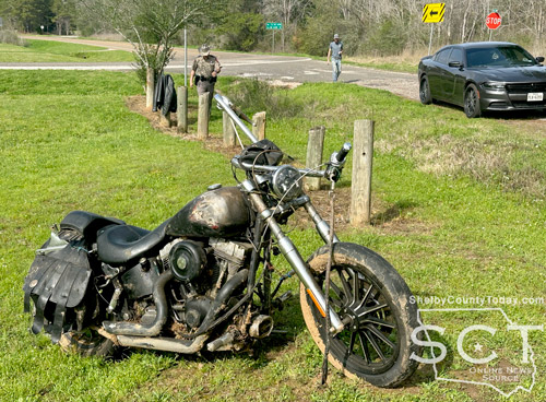
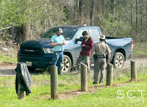
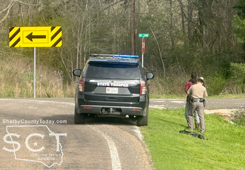
March 11, 2024 - FM 2140 was the scene of a single-vehicle motorcycle crash on March 8, 2024, in the Neuville area.
The driver reached out to a co-worker, Kris Risinger, as they were both driving in separate vehicles to meet their boss, Rafael Soto, to receive payment for their labor.
Texas Department of Public Safety (DPS) State Troopers were alerted of the incident and Trooper Dustin Ramos was dispatched to the scene.
According to the Texas DPS, at 2:03pm Troopers were dispatched to the scene and upon arrival it was determined a 2001 Harley Davidson motorcycle ridden by Cody Akers, 27, of Joaquin was southbound on FM 2140 at an unsafe speed.
Akers missed the right curve and traveled off the roadway through a ditch and came to rest in a field.
Akers refused treatment by EMS and was not reported to have received any injuries. He was issued citations for unsafe speed, no insurance, and no driver’s license.
Just after Trooper Ramos issued citations to Akers he continued his investigation, while Soto and Risinger left, and following the investigation Akers was arrested.
Hughes Wrecker Service then towed the motorcycle from the location.
According to the Shelby County Jail log, Akers was arrested for possession of marijuana <2oz, misdemeanor b.

Pages