

The story headline links to a better view of the story and share features.


News
February 15, 2024 – A speed limit reduction has been approved by Texas Transportation Commissioners on a busy Shelby County highway.
The speed limit on US 84 will be lowered from 70 mph to 65 mph from the city limits of Joaquin to 1.65 miles west. The Lufkin District conducted the prescribed engineering and traffic study to determine the recommended lower speed limit on this section of roadway.
Motorists are urged to stay alert and obey the new speed limit that is enforceable once signs are set.
February 14, 2024 - The Texas Commission on Environmental Quality required the Choice public water system on February 10, 2024, 2100005 to issue a Boil Water Notice to inform customers, individuals, or employees that due to conditions which occurred recently in the public water system, the water from this public water system was required to be boiled prior to use for drinking water or human consumption purposes.
The public water system has taken the necessary corrective actions to restore the quality of the water distributed by this public water system used for drinking water or human consumption purposes and has provided TCEQ with laboratory test results that indicate that the water no longer requires boiling prior to use as of 02/14/2024
If you have questions concerning this matter, you may contact, Matt Di Verdi 936-591-4346.
February 11, 2024 - Due to a broken water main the Texas Commission on Environmental Quality has required the CHOICE Water system, ID# 2100005 to notify customers that were without water 2/10/2024 on Hwy 96 north of 417 E (anyone without water) to boil their water, prior to consumption (e.g., washing hands/face, brushing teeth, drinking, etc). Children, seniors, and persons with weakened immune systems are particularly vulnerable to harmful bacteria, and all customers should follow these directions.
To ensure destruction of all harmful bacteria and other microbes, water for drinking, cooking, and ice making should be boiled and cooled prior to use for drinking water or human consumption purposes. The water should be brought to a vigorous rolling boil and then boiled for two minutes.
In lieu of boiling, individuals may purchase bottled water or obtain water from some other suitable source for drinking water or human consumption purposes.
When it is no longer necessary to boil the water, the public water system officials will notify customers that the water is safe for drinking water or human consumption purposes.
Once the boil water notice is no longer in effect, the public water system will issue a notice to customers that rescinds the boil water notice in a manner similar to this notice.
Please share this information with all the other people who drink this water, especially those who may not have received this notice directly (for example, people in apartments, nursing homes, schools, and businesses). You can do this by posting this notice in a public place or distributing copies by hand or mail.
If you have questions concerning this matter, you may contact Matt Di Verdi 936-591-4346.
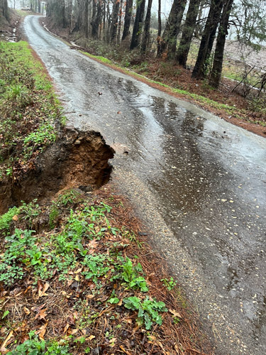
February 14, 2024 - CR 1024 is open to traffic.
February 10, 2024 - Roscoe McSwain, Commissioner Precinct 1, reports on Saturday, February 10, 2024, that CR 1024 is closed at the intersection of CR 1005 and at Mill Creek.

February 14, 2024 - The Shelby County Commissioners were able to move forward with their pugmill purchase during their February 7, 2024 meeting. They also allowed Constable Precinct 5 to add some equipment for his deputy and the Sheriff’s Department to use funds to purchase taser equipment.
Ann Blackwell, County Treasurer, indicated several items on weekly expenses for the commissioners to take not of including many entries for indigent care in the previous month, half of the audit, parts on constable trucks, inmate housing to Panola County, and a City of Center tax increment.
A motion made by Stevie Smith, Commissioner Precinct 3, was seconded by Tom Bellmyer, Commissioner Precinct 4, and the motion carried.
The commissioners discussed the purchase of a pugmill with ARPA (American Rescue Plan Act) funds, which they have been considering for some time now and have been ensuring all of the needed documentation was put together including the final quote for the purchase from the vendor and a sole-source document indicating the vendor is the only source of the equipment.
Roscoe McSwain, Commissioner Precinct 1, described other pugmill systems that are similar, but not the same to the one they are purchasing. The one they are seeking can be taken to the dirt location rather than requiring the product for processing be brought to the machine. The pugmill they will be getting is also one that he personally is familiar with operating.
“I also have the invoice for the 50% down, which is $254,244.50 so if y’all approve it we can move forward and get a check,” said Blackwell.
Blackwell explained the payment schedule of 50% down on initiation of the project and 25% more when it reaches 50% completion, and final 25% when the unit is complete at the factory.
County Attorney John Price confirmed the company met the requirements for a sole-source purchase.
A motion by Commissioner McSwain to approve the sole-source document and the final quote for the purchase of the pugmill and allow Ann Blackwell to make the down payment once she gets satisfaction of GrantWorks to move forward was seconded by Commissioner Lout, and the motion carried.
The commissioners considered an installation of Copsync equipment into Deputy Constable Precinct 5’s vehicle at a cost of $1,200. After discussion, a motion made by Commissioner McSwain was seconded by Commissioner Bellmyer, and the motion carried.
Clint Porterfield, County Auditor, presented a Budget Amendment for Fund 66 – Sheriff Forfeiture Account, and he explained to the commissioner why it is an amendment and not a line-item transfer. Also presented to the commissioners in relation to that was equipment the sheriff’s department is seeking for their taser training.
“September 29, we recorded a receipt for some asset sales through Purple Wave,” said Porterfield. “The Sheriff’s office sold three assets; we’d already done an adopted budget by then so they had money at the end of last year it just didn’t get into the adopted budget as far as a cash forward. So, they had $5,500 in sales, they need $3,000 worth of equipment, so all I want to do is recognize that sale and do a budget amendment in their fund 66 Sheriff Forfeiture account and then they can proceed to go ahead and buy the equipment they need out of their forfeiture account.”
A motion was made by Commissioner Stevie Smith to record the Budget Amendment for Fund 66 – Sheriff Forfeiture Account and the motion was seconded by Commissioner Bellmyer.
January 31 meeting - Commissioners Concerned About Sheriff's Department Overtime
When the commissioners were considering the payroll during the January 31, 2024, meeting Commissioner McSwain paid particular attention to the overtime at the Sheriff’s Department.
“It looks to be substantial and I hope everybody will start investigating and looking at that a little closer. A lot of it is one day holiday pay I think,” said McSwain. “There’s people there with $1,000 worth of overtime.”
Clint Porterfield provided some additional information for the commissioners in relation to overtime and he said there is an overtime report for every pay period.
“For nine pay periods, including the one just completed, we have $110,000 worth of overtime at the Sheriff’s Office,” said Porterfield. “Our budget is $75,000.”
Commissioner Bellmyer confirmed that was nine pay periods, 18 weeks, out of 26 pay periods.
“When I say that, I want to qualify it as saying that that is $30,000 more than the same nine periods last year,” said Porterfield. “Now keep in mind, we had some pay increases, but that’s $30,000 more, in nine pay periods.”
Porterfield continued by stating the county is on track for a substantial overtime expenditure.
McSwain continued to express his frustration at the amount of overtime and what he believes is due to mismanagement. He further stated the court may need to look at changing the overtime policy to prevent hitting what Porterfield warned is on track to reach over $300,000 in overtime.
“It comes down to management and no one’s keeping an eye on what’s going on,” said McSwain. “People are just turning in their time and doing as they damn well please, not getting their work done in their normal shift and then postponing and doing it in overtime.”
A motion by Commissioner Bellmyer to pay the current payroll was seconded by Commissioner Jimmy Lout, and the motion carried.
The commissioners discussed the agriculture, grazing, and hunting Lease on the Garza County property currently leased by Steven Hill.
A motion by Commissioner McSwain to assign the lease for the remainder of its term to Miles Underwood and waive the Worker’s Comp clause, was seconded by Commissioner Bellmyer and the motion carried.
The commissioners discussed participation in the DIR-Certified Cyber Security training program. There is a cost this year of $5 per person to enroll. The training is mandatory for any county official or employee that has access to county information electronically. This includes anyone who accesses email via their cell phone as well and computer access. Also approve Ann Blackwell, County Treasurer, or other person as the training program administrator.
A motion by Commissioner Stevie Smith to approve the program with a $5 fee and leave Ann Blackwell, County Treasurer, in charge of administrating the training was seconded by Commissioner Bellmyer, and the motion carried.
The meeting went into an executive session and when the court returned to open session no action was taken on anything discussed during executive session. The meeting was then adjourned.
January 24 meeting - Commissioners Confused By Sheriff's Department Expenditure
The Shelby County Commissioners discussed concerns during their January 24, 2024 meeting over replacement of 44 light fixtures at the Shelby County Sheriff’s Department and Jail at a cost of over $5,000 without approval of the court.
“We sent the invoice, I actually put the note on there with a request to have the invoice signed and approved and a request as to who authorized the work, said Clint Porterfield, County Auditor. “Since this was over $5,000 it qualifies as a asset purchase for depreciation purposes, because we’re not repairing a light, we’re replacing it.”
Porterfield related a response was received from Chief Deputy Ruth Gonzalez that 44 light fixtures were replaced with 25 of those being in the jail, dispatch and 19 in the front office and who ordered the work or approved it wasn’t able to be confirmed.
“I don’t recall that it came to court,” said Commissioner Bellmyer.
“No one ever said that to me,” said Judge Allison Harbison.
“We talked about it in detail on this building (courthouse), replacing lights, and it was approved by commissioners’ court,” said Commissioner Bellmyer.
Porterfield said, they have work that is done and the county owes the vendor $5,800.
“That goes without saying, we owe the vendor, it’s just that our Sheriff’s Department didn’t follow through the process of spending that kind of money on the building,” said Bellmyer.
Exasperated by the circumstances, Roscoe McSwain questioned, “How do you control this? I mean, what do you do? Make a post on Shelby County Today to all vendors, ‘Please do no work that you don’t know commissioners’ court has approved, by any county official?”
Ann Blackwell, County Treasurer, agreed especially over a certain amount.
“We would have been glad to do theirs if they would have let me put it on the agenda,” said Judge Harbison. “It would have all been out in the open and we could have all talked about it.”
Blackwell stated that when the bill arrived in November it would have been known what the invoice was for and it could have been paid at that time rather than learning three months later what the bill was for and the vendor wouldn’t have had to wait for three months to be paid.
“I vaguely remember Chad Hooper saying that they needed to replace a couple of lights, but a couple of lights is not 44 lights,” said Judge Harbison.
Porterfield described the request for information having to be submitted more than once.
“The January 19 response on the number of fixtures was only because we requested again,” said Porterfield. “We sent it back over with the same note on it, ‘who ordered it, who approved it, how many did you get?”
Judge Harbison asked who ordered the fixture replacement, and if the Sheriff’s Department ever said and Porterfield said they did not.
Judge Harbison stated that it was very concerning to her.
A motion was made by Commissioner Roscoe McSwain to move forward and pay the weekly expenses, and the motion was seconded by Commissioner Stevie Smith. The motion carried.
The commissioners discussed seeking bids on renovating the Community Room on the 2nd floor into a County Courtroom adding offices and updating the kitchen/break room area.
Judge Allison Harbison outlined a variety of updates on the second floor for the commissioners to consider.
A motion by Commissioner McSwain for RFQ (Request for Quotes) for construction for the courtroom only at this time, was seconded by Commissioner Bellmyer and the motion carried.
The commissioners considered an updated service agreement with the Texas Association of Counties (TAC) for email and website hosting services.
Auditor Porterfield gave some background on the agreement.
“We signed a service agreement just like this in 2021, that’s when TAC offered Microsoft 365 platform and they also host our email and our website services, and we signed a contract just like this,” said Porterfield.
Porterfield said the update appears to only to change some payment terms, and really doesn’t impact Shelby County as much as those with larger accounts. The only other change he noted in the contract was a requirement to list the email administrators who are Porterfield, Ann Blackwell, Treasurer; and Leah Chase, Sheriff’s Department Administrative Secretary.
“I chose for this, the middle level, that means we don’t have security access,” said Porterfield. “So, none of the three of us can go into this system and change any security settings, that would have to be done by an IT professional.”
Porterfield updated the email numbers as the original number they had in the original contract was 80, and then 40 more were added, so the current numbers is 120.
Porterfield wanted to make clear, “We do not have access to read someone else’s email account as an administrator.”
Blackwell concurred; they can only reset the password for the user.
A motion by Commissioner Bellmyer to approve the updated service agreement, was seconded by Commissioner Jimmy Lout, and the motion carried.
The commissioners discussed the lease on the Garza County Property which the county possesses. Steven Hill, who has been the lessee, is seeking to end his lease this year and for his neighbor to carry on the lease.
The commissioners continued to discuss the county Sick Leave policy and potential changes, which they hope will help provide equal sick leave assistance for all employees.
“Here’s the reason I want to move forward with this, because it’s not fair, because a lot of people have been good to give to my guy that’s sick and his time ends, he’s fixing to get his last check and he’s done with the county,” said McSwain. “But, somebody at the Sheriff’s Department might get sick, and there’s been several people at the Sheriff’s Department did make extra time, well nobody might not give him no time or your employee might not give them time like they gave my employee, because they know each other. That’s why we need this, it makes it fair for everybody.”
A motion by Commissioner Bellmyer to table for one week was seconded by Commissioner McSwain and the motion carried.
The meeting was adjourned at 10:21am.
Agenda items approved during the February 7, 2024 meeting include:
1. Pay weekly expenses.
2. Sole-source document and final quote for purchase of the Pugmill through ARPA funds.
3. Install Copsync equipment into Deputy Constable Pct. 5’s vehicle.
4. Record Budget Amendment for Fund 66 – Sheriff Forfeiture Account.
5. Recognize and record completion of required continuing education certificate for Allison Harbison, County Judge.
6. Recognize and record completion of required continuing education certificate for Jennifer Fountain, County Clerk.
7. Continuing Education Transcript for Tax Assessor-Collector Debora Riley, for evidence of compliance with Texas Property Tax Code Sec 6.231(d) no action needed.
8. Record Racial Profiling Report for Johnny Harrington with Adult Probation.
9. Adjourn.
Agenda items approved during the January 31, 2024 meeting include:
1. Pay weekly expenses.
2. Pay current Payroll.
3. Agriculture, Grazing, and Hunting Lease on the Garza County Property currently leased by Steven Hill assigned to Miles Underwood and waiver of Worker’s Comp clause.
4. Participation in the DIR-Certified Cyber Security training program with a fee of $5 per person to enroll and leave Ann Blackwell, County Treasurer, in charge of its administration.
5. Adjourn.
Agenda items approved during the January 24, 2024 meeting include:
1. Pay weekly expenses.
2. Go out for bids on renovating the Community Room on the 2nd floor into a County Courtroom adding offices and updating the kitchen/break room area.
3. Updated Service Agreement with the Texas Association of Counties for email and website hosting services.
4. Adjourn.
Agenda items tabled during the meeting include:
1. Update on Sick Leave Policy for County Employees.
February 13, 2024 - Notice is hereby given that the automatic tabulating equipment that will be used in the March 2024 Primary Election, held on March 5, 2024, will be tested on Thursday, February 15, and Friday, February 16 at 9am, in the Shelby County Clerk’s office in Center, to ascertain that it will accurately count the votes cast for all offices and on all measures.
Aviso Publico De Prueba De Equipos De Tabulación
Por la presente se notifica que el equipo de tabulación automática que se utilizará en las Elecciones Primarias de marzo de 2024, que se llevarán a cabo el 5 de marzo de 2024, se probará el jueves 15 de febrero y el viernes 16 de febrero a las 9:00 a.m., en la oficina del Secretario del Condado de Shelby en Center, para determinar que contará con precisión los votos emitidos para todos los cargos y en todas las medidas.

February 13, 2024 - CR-4323; the water has receded, and the roadway is open to all local traffic.
February 11, 2024 - Commissioner Tom Bellmyer reports on February 11, 2024, that County Road 4323 has water over the road.
It is deeper today than the last flooding incident two weeks ago, and is unsafe for an automobile to cross at this time.
February 12, 2024 - Due to the recent rainfall, all lake levels have returned to full capacity. As such, all water conservation measures and restrictions are no longer required.

City of Center Implements Water Restrictions Due to Drought Conditions
August 21, 2023 - Drought conditions are widespread across the state. The City of Center is experiencing severe drought conditions with no rain forecast in the near future. Stage 1 of the Water Conservation and Drought Contingency Plan has been triggered and must be implemented. Stage 1 water restrictions and watering schedule are as follows:
- Watering of landscape, even addresses Wednesday and Saturday, odd addresses Thursday and Sunday; water between 6 p.m. and 6 a.m.
- Reduce non-essential water usages in the home or business
- Repair known leaks (dripping faucets, running toilets)
With your help, these measures could reduce the water demand and hold off further restrictions set forth in the Drought Contingency Plan required by the State of Texas.
February 11, 2024 - Precinct 2 reports on February 11, 2024, that County Road 2625 (Oakdale Road) is washed out and unsafe for travel.
Please don’t drive through, or move barricades, they are there for your safety and that of others

February 10, 2024 - Stevie Smith, Commissioner Precinct 3, reports on Saturday, February 10, 2024, that a portion of County Road 3173 is under water and impassable.
February 9, 2024 - On 2/5/24, the Texas Commission on Environmental Quality required the City of Tenaha public water system, 2100002, to issue a Boil Water Notice to inform customers, individuals, or employees that due to conditions which occurred recently in the public water system, the water from this public water system was required to be boiled prior to use for drinking water or human consumption purposes.
The public water system has taken the necessary corrective actions to restore the quality of the water distributed by this public water system used for drinking water or human consumption purposes and has provided TCEQ with laboratory test results that indicate that the water no longer requires boiling prior to use as of 2/9/24.
If you have questions concerning this matter, you may contact Stacy Cranford at
February 5, 2024 - Due to line break, the Texas Commission on Environmental Quality has required the City of Tenaha PWS #2100002 public water system to notify all customers in the Center Street Area to boil their water prior to consumption (e.g., washing hands/face, brushing teeth, drinking, etc.). Children, seniors, and persons with weakened immune systems are particularly vulnerable to harmful bacteria, and all customers should follow these directions).
To ensure destruction of all harmful bacteria and other microbes, water for drinking, cooking, and ice making should be boiled and cooled prior to use for drinking water or human consumption purposes. The water should be brought to a vigorous rolling boil and then boiled for two minutes.
In lieu of boiling, individuals may purchase bottled water or obtain water from some other suitable source for drinking water or human consumption purposes.
When it is no longer necessary to boil the water, the public water system officials will notify customers that the water is safe for drinking water or human consumption purposes.
Once the boil water notice is no longer in effect, the public water system will issue a notice to customers that rescinds the boil water notice in a manner like this notice.
Please share this information with all the other people who drink this water, especially those who may not have received this notice directly (for example, people in apartments, nursing homes, schools, and businesses). You can do this by posting this notice in a public place or distributing copies by hand or mail.
If you have questions concerning this matter, you may contact Stacy Cranford at 936-248-3841or City Hall located at 238 North George Bowers Drive Tenaha Texas 75974.
Pages