

The story headline links to a better view of the story and share features.


News
October 20, 2016 - The Shelby County grand jury for the July Term 2016 of the 123rd Judicial District Court met Wednesday, October 20, 2016 and indicted 42 cases.
Elizabeth Perez was indicted for theft, state jail felony, The indictment alleges, on June 29, 2015 Perez unlawfully appropriated a 2002 blue Chrysler Voyager van from Michael Mcilrath without his consent and with intent of depriving Mcilrath of the property.
Joseph David Fuller was indicted for evading arrest, third degree felony. The indictment alleges, on January 23, 2016 Fuller fled from Center Police Officer Andrew Williams, a person whom Fuller knew to be a peace officer. Fuller was also indicted for tampering with or fabricating physical evidence, third degree felony. The indictment alleges during the traffic stop Fuller concealed a bottle of vodka with intent to impair its availability as evidence.
Shaddrick Tawan McCollister received two indictments for arson, second degree felony. The first indictment alleges, on August 12, [2016] McCollister with intent to destroy a building located at 306 Travis Street in Center, started a fire, or caused an explosion by building a fire on the floor and in the attic.
The second indictment alleges on August 29, [2016] McCollister, with intent to destroy a building located at Hidden Creek Village on Shelbyville Street, started a fire or caused an explosion by attempting to burn down a trailer house.
Spencer Ryan Niedert was indicted for theft, state jail felony. The indictment alleges on March 24, 2014 Niedert unlawfully appropriated a 2006 Yamaha Rhino 660 valued between $2,500 or more but less than $30,000 from William Darrell Partlow, the owner, without his consent.
Virginia Hunter was indicted for unauthorized use of a motor vehicle, state jail felony. The indictment alleges on January 10, 2016 Hunter operated an automobile without the effective consent of William Skillern, the owner.
Jeremy Danzell Edwards was indicted for burglary of a habitation, second degree felony. The indictment alleges on January 15, 2016 Edwards entered a habitation without the effective consent of Leonard Boehm, the owner. Edwards is also alleged to have attempted to commit or committed theft of a Stihl chainsaw, Husqvarna chainsaw, Homelite 4300 generator, Troy-built pressure washer, and a Brute pressure washer.
Bradley Joe Lewis was indicted for theft of firearm, state jail felony. The indictment alleges on December 9, 2015 Lewis appropriated a firearm from Hope Nunez, the owner, without the consent of Nunez and with intent to deprive Nunez of the property.
Devalen Devone McCowin was indicted for aggravated sexual assault of a child, first degree felony - enhanced. The indictment alleges on or about the year 2013 to 2014 McCowin caused the penetration of the mouth of a child younger than six years of age by McCowin's sexual organ.
Bradly Ray Willard was indicted for theft, state jail felony. The indictment alleges on January 5, 2016 Willard appropriated scrap metal valued at $1,500 or more but less than $20,000 from Larry Sample, the owner, without Sample's consent.
Terry Lynn Cummings was indicted for hindering apprehension or prosecution, third degree felony. The indictment alleges on January 2, 2016 Cummings, with intent to hinder the arrest, prosecution, conviction or punishment of Stacy Smith for the offense of a motion to revoke probation warrant for injury to a child by harboring or concealing Smith.
Anthony Salas was indicted for assault by occlusion, third degree felony. The indictment alleges on January 28, 2016 Salas recklessly caused bodily injury to Andrea Chadwick by intentionally, knowingly and recklessly impeding the normal breathing or circulation of the blood of Chadwick by applying pressure to her throat or neck.
Justin Dewayne Bridges was indicted for theft, third degree felony. The indictment alleges on September 30, 2015 Bridges appropriated $4,800 U.S. Currency from George May, the owner, who was then an there an elderly individual and without his effective consent.
Brandy Emmel Hasler was indicted for forgery, state jail felony. The indictment alleges on August 15, 2015 Hasler, with intent to harm or defraud another, executed a writing so it purported to be the act of Jacqueline Jeanette Brown, who did not authorize the act. The writing was checking account numbers and routing numbers which contain personal information assigned to Brown and used the accounts and routing information to pass fraudulent checks, all without Brown's consent.
Arturo Luna was indicted for continuous violence against the family, third degree felony. The indictment alleges on March 30, 2016 Luna recklessly caused bodily injury to a person, with whom the defendant had or previously had a dating relationship, by pushing the individual during an argument on July 15, 2014. The indictment also alleges Luna recklessly impeding the normal breathing or circulation of the blood of the individual by applying pressure to the throat or neck and/or blocking the nose or mouth of the individual.
Joe Allen Cooks was indicted for assault on a public servant, third degree felony. The indictment alleges on May 27, 2015 Cooks recklessly caused bodily injury to Jimmy Wagstaff by striking him in the face. The defendant did then and there know that Wagstaff was a public servant, Tenaha City Marshal discharging his duty via an investigation.
Johnny Lee Stanley was indicted for burglary of a habitation, second degree felony. The indictment alleges on September 18, 2015 Stanley entered a habitation without the effective consent of Franklin Hairgrove, the owner, and attempted to commit or committed theft of two bottles of medication owned by Hairgrove.
Cody Arlan Pate was indicted for theft, state jail felony. The indictment alleges on October 6, 2015 Pate unlawfully appropriated various items of jewelry, including 1 gold chain with horseshoe pendant, 10 pair gold studded earrings, 4-5 bicentennial dollars, gold necklace with beads, jewlery box and game camera. All valued at $1,500 or more but less than $20,000 from Patricia Clepper, the owner, without her effective consent.
(Dates in parenthesis indicate the date of the alleged incident)
Kyle Aaron Meche, driving while intoxicated, third degree felony (February 3, 2015).
Bradley Joe Lewis, unlawful possession of firearm, third degree felony (December 9, 2015).
Anthony Salas, possession of a controlled substance (methamphetamine), state jail felony (February 29, 2016).
David Len Weaver Jr., possession of a controlled substance (methamphetamine), third degree felony (January 12, 2016).
Redaryll Zacharvick Davis, delivery of a controlled substance, first degree felony (November 24, 2015).
Eddie Lowry Lockey II, driving while intoxicated, third degree felony (March 27, 2015).
Baylon Guillermo, driving while intoxicated with child passenger, state jail felony (July 31, 2015).
Adam Trey Pleasant, possession of a controlled substance (methamphetamine), third degree felony (May 7, 2015).
Benjamine Brian Odom, possession of a controlled substance (methamphetamine), state jail felony (October 29, 2015).
Gary Watts, possession of a controlled substance (methamphetamine), state jail felony (December 26, 2015).
James Ray Matlock, driving while intoxicated, third degree felony (October 6, 2015).
Trevor Cole Lawrence, possession of a controlled substance (methamphetamine), third degree felony (May 6, 2015).
Serviano Vazquez Munoz, driving while intoxicated, third degree felony (December 25, 2015).
Robert Nathan Stephenson, driving while intoxicated with child passenger, state jail felony (November 26, 2015).
Thomas Orvis Crocker, driving while intoxicated, third degree felony (August 22, 2015).
Javier Jesus Gonzalez, possession of a controlled substance (methamphetamine), state jail felony (May 27, 2015).
Elroy Young, possession of a controlled substance (cocaine), state jail felony (June 11, 2015).
Kevin Earle Davis, possession of a controlled substance (methamphetamine), state jail felony (December 31, 2015).
Stacy Kelton Samford, driving while intoxicated, third degree felony (December 5, 2015).
Stacy Kelton Samford, possession of a controlled substance (methamphetamine), state jail felony (December 5, 2015).
Triston Jamar Driver, tampering with or fabricating physical evidence, third degree felony (January 30, 2016).
Jerry Wayne Akins II, unlawful possession of firearm, third degree felony (January 9, 2016).
Redaryll Zacharvick Davis, unlawful possession of firearm, third degree felony (November 24, 2015).
Indictments and Information are not a conviction, and are a matter of public record. All individuals are presumed innocent until found guilty in a court of law.
October 20, 2016 - Reminder: Timpson ISD is having a Site Evacuation Drill at 10am today, October 20, 2016. The Timpson Fire Department and Police Department may be participating in the drill as well.

October 20, 2016 - (Update): According to the Shelby County Sheriff's Department, Tarver was found safe at a residence on State Highway 7 West in Center on Wednesday night, October 19, 2016.
October 13, 2016 - The family of an 18-year-old who has been missing since October 10, 2016 is seeking the public's help in locating her. Christina (Chrisi) Tarver was last reported being seen Monday between 1:30am and 4:30am off CR 3047 not far from Center.
 Currently the Shelby County Sheriff's Department is investigating her disappearance and according to Tarver's mother, Larenda Murphy, she has now been listed as a missing person.
A message was received by Murphy through her cell phone which was supposed to be from her daughter, but Murphy says she doesn't think it was Tarver and no one has heard from her.
Murphy asks that anyone with any information about the location of her daughter contact her at 936-371-3172 or the Shelby County Sheriff's Department at 936-598-5600.
 October 19, 2016 - The Shelby County Sheriff’s Office reports the arrest of Johnie Gamble IV.
SCSO Lieutenant Kevin Windham was contacted Sept. 26 by Sheri Moore Miller in reference to a softball tournament hosted by Gamble on behalf of her son who was recently diagnosed with cancer. Miller stated the tournament was held Aug. 27 and approximately $1,000 was raised to help the family with medical expenses.
Miller told Lt. Windham that the money was to be deposited into a GoFund Me account established for her son. Miller stated she and her husband had both spoke to Gamble concerning the money and he stated he would give them the money.
On Sept. 26, Lt. Windham spoke with Gamble and gave him the opportunity to come to the SCSO and provide a statement but Gamble chose not to do so. Gamble stated to Lt. Windham that he had not given the money to Miller because he was going to put himself and his family before others.
Gamble was arrested Oct. 18 at his residence in Joaquin. He was charged with Exploitation of a Child, Elderly or Disabled Person (F3) W#1118-16 and Resisting Arrest (MA). Gamble bonded out Oct. 19 on $13,000 total bonds.
October 18, 2016 - Many Shelby County residents and businesses experienced an interruption in their internet service Monday, October 17, 2016 due to an outage resulting from a cut fiber optic line.
According to AT&T Customer Service 2,240 customers were without service on Monday afternoon. Shelby County Today reached out to AT&T Media relations Monday evening for information regarding the outage and they issued the following statement Tuesday morning.
"Due to a cable cut, some customers in the Shelby County area may have experienced service issues late yesterday. Our technicians worked through the night and completed repairs on their damaged cable and our service is currently running normally. We apologize for this inconvenience."
It was reported to Shelby County Today, other outages recently experienced in Shelby County on September 9 and October 11 were due to fiber optic lines being cut.
Customer reports on social media indicate customers in Timpson, Center and San Augustine were effected by the outage.
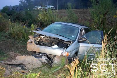
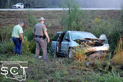
October 15, 2016 - Emergency crews were dispatched to the intersection of U.S. Highway 96 North and Loop 500 just outside of Center Friday, October 14, 2016 after a van took a nosedive into a ditch.
When the Center Fire Department, Center Police Department and ACE EMS arrived on scene the passenger of the van was out and the driver remained inside.
According to Texas Department of Public Safety State Trooper Austin Lunsford, at 6:44am a blue 2003 Chrysler Town and Country LX van driven by 2016 Dale Helm, 73, of Milam with passenger Michael Hagler, 67, of Milam was traveling west on SL 500.
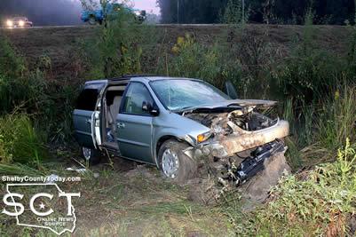
Trooper Lunsford reports Helm disregarded the stop sign at the intersection of SL 500 and U.S. 96 traveling through the intersection and into a ditch on the other side of the roadway where the Chrysler collided with its front end in the ditch.
ACE EMS transported both the driver and passenger to Nacogdoches Medical Center - Center Emergency Department for treatment of their injuries. Helm was issued a citation for disregard stop sign and Hagler was issued a citation for no seat belt.
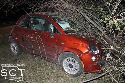
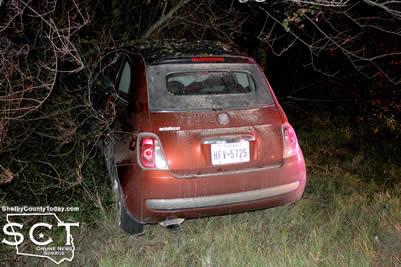
October 14, 2016 - U.S. Highway 96 North was the scene of a single-vehicle crash Monday, October 10, 2016.
When Texas Department of Public Safety (DPS) State Troopers arrived at the scene, the vehicle involved was partially in a wooded area beside the road.
According to Texas DPS Trooper Keith Jones, at 8:20pm Christina Lynn Patterson, 18, of Tenaha was southbound in an orange 2012 Chrysler Fiat on U.S. Highway 96 just north of CR 3765.
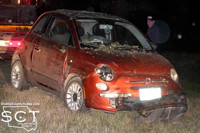
As Patterson traveled in the outside lane, she failed to drive in a single lane and lost control of the vehicle. This caused the Fiat to exit the right side of the roadway striking small brush.
No injuries were reported as a result of the crash. Patterson was issued a citation for fail too drive in a single lane.
Assisting at the scene were Texas DPS Troopers Jesse Fountain and Dustin Ramos.
October 13, 2016 - Shelby County Commissioners’ Court is now taking bids on the demolition of the old Shelby General Hospital building located at 114 Hurst Street, Center, Texas. The bid should also include debris removal and disposal. Proof of Workers’ Compensation and Liability Insurance in the amount of $2,000.000.00 required. All bids should be submitted to: Allison Harbison, Shelby County Judge, 200 San Augustine Street, Box 6, Center, Texas 75935 by November 10, 2016 at 3:00 P.M.
October 13, 2016 - An election is hereby ordered to be held on November 8, 2016, in Shelby County, Texas for the purpose of electing the following county and precinct officers as required by Article XVI, Section 65 of the Texas Constitution.
List of Offices: District Attorney, County Attorney, County Sheriff, County Tax Assessor/Collector, County Commissioner - Precincts 1 and 3, and Constables - All Precincts.
Early voting by personal appearance will be conducted each weekday at the Shelby County Clerk's Office, 124 Austin Street, Center, Texas.
Monday, October 24th from 7am - 7pm
Tuesday, October 25th to Friday, October 28th from 8am - 4:30pm
Monday, October 31st from 7am -7pm
Tuesday, November 1st to Friday, November 4th from 8am - 4:30pm
Additional weekend early voting will be held as follows:
Saturday, October 22, 2016 from 10am -2pm and Sunday, October 23, 2016 from 12noon - 4pm.
Applications for ballot by mail shall be mailed to:
Jennifer Fountain - Shelby County Clerk
P.O. Box 1987
Center, Texas 75935
Applications for ballots by mail must be received no later than the close of business on Friday, October 28, 2016.
To see the full Order of General Election with Spanish translation, click here.
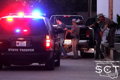
October 10, 2016 - The intersection of Banks Street and Austin Street was a point of interest for many traveling the Center Square early Monday evening as Austin Street was blocked by law enforcement officers performing an investigation.
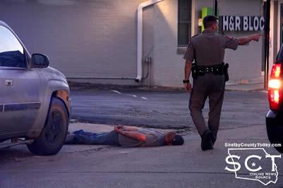
Sometime just before 7pm October 10, 2016 officers with the Texas Department of Public Safety (DPS), Center Police Department and Shelby County Sheriff's Department converged on the location.
The Shelby County Sheriff's Department alerted DPS of a possible altercation between two vehicles and the occupant of one vehicle displaying a firearm. Once the individuals in the vehicles finally stopped on Austin Street, they were all detained and placed in handcuffs during investigation.
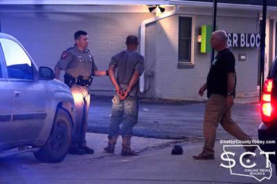
The individuals were determined to be connected with an incident earlier in the day involving a possible stolen RV which the Sheriff's Department was already in the process of investigating.
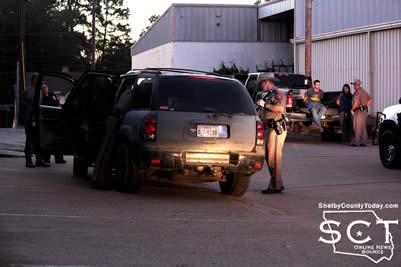
Once the investigation at the scene was completed, the individuals from the two vehicles were released. The RV was then retrieved and transported to the Shelby County Sheriff's Department pending further investigation.
More information on this incident will be provided as it is made available.
Pages