

The story headline links to a better view of the story and share features.


News
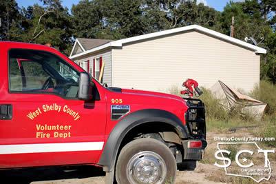
October 6, 2016 - West Shelby Volunteer Fire Department was dispatched to a house fire located on the west end of ongoing construction at 6713 State Highway 7 West October 5, 2016 at 4:55pm.
When firemen arrived the house had not yet caught on fire, but an oven within the house was overheating, generating smoke in the house.
The firemen ventilated the house with a fan and prevented the house from going up in flames.
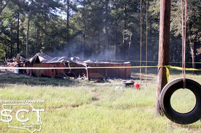
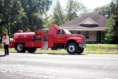
October 6, 2016 - The Timpson Volunteer Fire Department responded to a house fire on Wednesday, October 5, 2016 at the intersection of CR 4699 and CR 4694 at 8:43am.
When the firemen arrived, the house had obviously been burning long before they were called, and the house had completely burned down. At that time, the Timpson VFD requested a law enforcement officer at the scene.

Sean Coley, the resident who was renting the house from Jerry Wood, was not home at the time of the fire and the cause was not determined. Power was not running to the residence at the time of the fire.
Robert Hairgrove, Constable Precinct 5, was dispatched to the scene and he documented the incident.
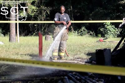
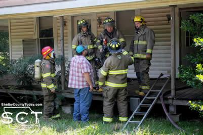
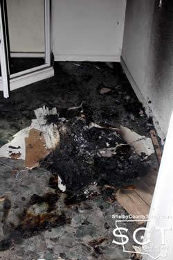
October 4, 2016 - The Timpson Volunteer Fire Department was dispatched to a house located on Ross Graves Drive at 1:37pm October 2, 2016 where the firemen learned three individuals were seen fleeing the house.
Although the address was unknown to dispatchers the firemen arrived at the intersection with Pecan Street where they were able to determine the house in question by smoke escaping the building. The firemen prevented the building from going up in flames and discovered the point of origin for the fire in a bathroom toward the rear of the house where it was apparent someone had set debris on fire.

Eyewitness accounts stated three juveniles were seen running from the house as smoke exited the building. The Timpson VFD made multiple requests to the Shelby County Sheriff's Department for an officer on scene and were informed no one was available and a Timpson officer who was not yet on duty would be en route.
Timpson Police Officer Jake Metcalf arrived on scene at 2:35pm and entered the house with firemen who led him to the origin of the fire. Officer Metcalf began witness interviews and searched the area with fireman Greg Hailey in efforts to locate the responsible parties.
At this time the fire remains under investigation by the Timpson Police Department. More information will be provided as it is made available.
October 4, 2016 LUFKIN – The Texas Transportation Commission approved last week $1.1 million earmarked for improvements to the Center Municipal Airport. The money is designated for electrical, pavement and drainage improvements at the airport.
Commissioners approved a total of $17.9 million for improvements in rural airports that included Alice International Airport, Arlington Municipal Airport, Coulter Field (Bryan), Castroville Municipal Airport, McKinney National Airport, South Texas Regional at Hondo Airport, Stephenville Clark Field and Sugar Land Regional Airport.
Improvements are funded through TxDOT’s Aviation Facilities Grant Program, which preserves and improves the state’s general aviation system. TxDOT expects this year to provide approximately $60 million in funding for planning, constructing and maintaining approximately 275 community airports in Texas that are eligible for federal and state funding.
More than three million flight hours are logged in arrivals and departures each year from Texas community airports, which additionally provide aircraft facilities for agricultural, medical, business and commuter use.
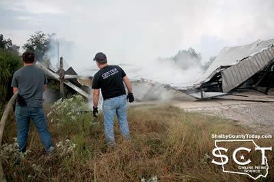
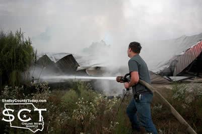
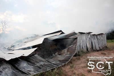
October 3, 2016 - The Center Fire Department was dispatched to a structure fire Sunday, October 2, 2016 at 6:45am on CR 3016.
Upon arrival at the scene, a barn in which it appeared chicken litter was being stored had burned to the ground.
Any flames which were emitting from the structure were extinguished by the firemen to help prevent further spread.
The firemen left the scene at 7:17am.
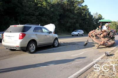
October 3, 2016 - State Highway 7 West just outside of Center was the scene of a two-vehicle crash Monday, October 3, 2016.
According to Texas Department of Public Safety State Trooper Taylor Buster, at 5:11pm Ingnacio Godines Ramirez, 63, of Bronson was eastbound on a John Deere tractor for K&L Contractors with a brush hog attached just under a mile from Loop 500 in front of Hughes Wrecker Service. At that time Collin Bush, 31, of Center was traveling in the same direction in the outside lane in a Chevrolet Equinox when the Equinox rear-ended the tractor.

The Center Fire Department was dispatched to the scene for support and they provided traffic control at the scene. Ramirez and Bush were both transported by ACE EMS to Nacogdoches Medical Center - Center Emergency Department for treatment of minor injuries.
Bush was issued a citation for failure to control speed.

October 2, 2016 - Shelby County Facebook users have been sending a post viral over the past 24 hours which warned of an experience a mother and her daughter had at a store in Center involving two Asian men who made her feel like they were being targeted for abduction. At the time of this story, the post which was made by Holly Bonner and gave a full description of the occurrence had 1,757 shares.
A similar incident was reported in Tenaha on a different Facebook post by Marshay McClure on Saturday, October 1st where a woman was watching her kids play along with other kids. She reported two males driving a grey Toyota car and it followed another child home. According to both posts, reports were made to local law enforcement.
It is unknown for certain if the men had ill will for them; however, it is a good reminder to all to be aware of your surroundings and know what to do in the event you yourself feel threatened.
There are many online resources for parents, kids, and teens to help them be avoid being taken and how to be prepared if someone does go missing.
kidshealth.org - Preventing Abductions (http://kidshealth.org/en/parents/abductions.html#)
- Have ID-like photos taken of your kids every 6 months and have them fingerprinted. Many local police departments sponsor fingerprinting programs. The Center Police Department Young Explorers have offered fingerprinting at various festivals and events.
- Make online safety (http://kidshealth.org/en/parents/net-safety.html) a priority. Your kids can be stalked online and not just at a store or playground.
- Set boundaries about the places your kids go and supervise them in places like malls, movie theaters, parks, public bathrooms.
- Never leave kids alone in a car or stroller, even for a minute.
- Avoid dressing your kids in clothing with their names on it - children tend to trust adults who know their names.
safewise.com - What to Do If You Think You're Being Followed (http://www.safewise.com/blog/what-to-do-if-you-think-youre-being-followed/) This website gives practical tips that will help you keep a level head and stay safe if you're suspicious that someone is following you. - Keep Calm, Pay Attention, Mix Things Up, Go Where the People Are, Break Out Your Phone, or Call the Police.
Don't ignore a bad feeling of uneasiness and don't be ashamed for feeling afraid. Remember the old saying, "It's better to be safe than sorry."
Facebook Post by Holly Bonner posted Friday, September 30th at 11:54pm
I am thanking God right now for keeping Halle & I safe tonight. I feel very strongly that we were being targeted to be abducted at Burke's Outlet in Center by two men.
David & I took our kids to Center to eat and run a couple of errands. I wanted to stop at Burke's Outlet to look for a purse, so the boys sat in the truck while Halle and I ran in the store. I told Halle I was going in to look for a purse and she said she wanted to go look at the shoes, I literally said to her, "Ok, that's fine--this store is small enough I can see you; I'll be over there in a few minutes." (Obviously that won't be happening again.)
So we go on about our shopping, I find a purse and go to the shoe section where she is. She's showing me a pair of shoes that she likes and I notice this man walking around the shoe section several times, nothing in his hands, no buggy, just walking around. He is a small framed Asian man, probably about 36-40 years old, wearing round frame glasses, a pair of baggy khaki pants and a big leather jacket. He walks by us, looking at Halle, smiling and says, "Oh..did you find something pretty?" She immediately smiles and says, "Yes sir!" Then she turns and looks at me and says, "He is really sweet!" Immediately my instinct told me something wasn't right.
I told her we needed to get going and that Daddy was sitting in the truck waiting on us. (I tried to say it enough times and loud enough that he would hear me--didn't work.) Halle is not satisfied with leaving the store empty handed and I didn't want to alarm her too much bc she would get all worked up, plus what if I was overreacting?! So I found a pair of Ram blue shoes that I told her would be really cute for school, she agrees and goes to try them on. As she sits down to try them on the man walks back by and says, "I like those on you!" and gives her the kind of adoring look that would freak out any mother. At this point I'm started to really know in my gut that really we need to leave. I tell Halle in a stern voice that it's time to go--now. She finally starts toward the front of the store with me. We check out and I never notice the man while we are checking out, so I assume he just went on about his business. Nope.
As we are walking to the door another Asian man, younger and more of an athletic build, comes out from no where (I hadn't seen him in the store at all) and walks out the doors adjacent to the ones I'm walking out of and gets between us and the exit doors. (There are two sets of doors to get into the store.) I push my cart to where all the other carts are and I notice he is just standing there watching us. At this point I'm freaking out in my head. We walk toward the door and he gets to the door first; I turn and notice the first guy coming very quickly toward us, so we are between the two men. A lady with a couple kids opens the door from the outside and they kind of walk in between us all, thankfully. At this point I am able to grab Halle's hand firmly and begin walking toward the truck. When I do Halle looks at me, obviously not aware of what is happening and I say, "Hold my hand. Hard." I look over my shoulder and they are coming toward us briskly until they notice David sitting in the truck we are going toward.
As soon as we got in the truck I told David what happened and we went to the sheriff's depart and talked to a deputy.
I am not over exaggerating or overthinking it when I say I believe, with every ounce of my being, that they were going to try to abduct us. I am very thankful that I listened to my gut. But I am more thankful that God was watching over us.
It's a very sad and scary world we live in. Please be careful. You think this kind of situation would never happen to you, but it can. You think this only happens in big cities, but it doesn't--it happens everywhere. Keep your kids beside you at all times in public. If your gut says to leave, do. Leave the buggy. It doesn't matter. Ask someone to escort you to your car. Get your phone out and start talking on it like there is someone picking you up at the front door of the store. Look them dead in the eyes--let them know you are aware of what they are doing. Talk to your kids about these kind of situations. Come up with a code word to use with your kinds in these types of situations. Above all, pray for safety and protection. And get some mace spray.
I am so very thankful to be able to put my Halle girl to bed tonight. That could've ended up so differently.
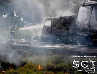
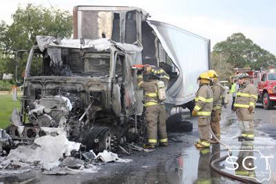
September 30, 2016 - The Timpson Volunteer Fire Department was dispatched to the intersection of U.S. Highways 59 and 84 on September 27, 2016 for a truck on fire.
When the firemen arrived, a truck-tractor was on fire and the flames were threatening to catch the trailer it was hauling.
The driver Karl Pierce, 81, of Chillicothe, Oh. stated as he was driving the truck just started to go up in flames. He grabbed a fire extinguisher from within the cab of the truck and tried to put out the fire, but it quickly overtook the truck.
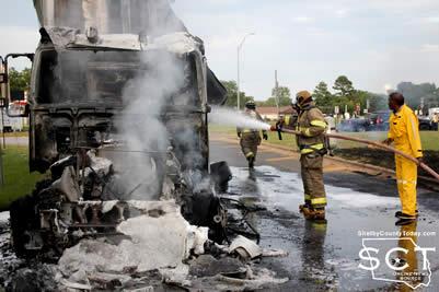
The firemen were able to extinguish the flames and the Garrison VFD provided support at the scene. The truck did burn completely to the ground. Timpson Police Department and Garrison Police Department were also on scene providing assistance to the fire departments.
One fireman appeared to have been overcome with heat exhaustion and the Timpson Volunteer Ambulance Service who was on scene responded quickly to his aid and transported him to Nacogdoches for treatment. He was released from the hospital on the day following the fire.
No injuries were reported to have been incurred by Pierce. Removing the vehicle which had been burned to the ground was a long and tedious task. TxDOT was also later called to the scene.
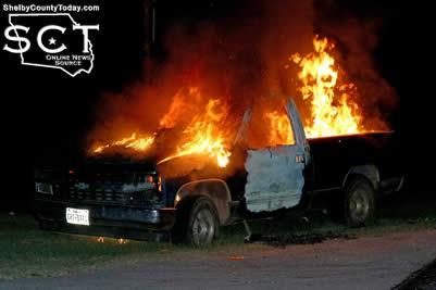
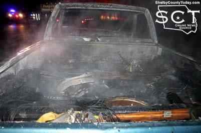
September 29, 2016 - When a passerby witnessed flames emitting from a truck parked in front of Parker's Package store just north of Shelbyville on State Highway 87 South Sunday, September 25, 2016 they immediately called the Shelby County Sheriff's Department at 10:04pm.
The Shelbyville Volunteer Fire Department was dispatched to the scene and when they arrived the Chevrolet pickup truck was engulfed in flames. The firemen extinguished the flames and prevented them from spreading to nearby buildings.
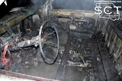
A cause for the fire could not be determined at the time of the fire. The truck had been sitting by the roadway for almost two weeks previous to the fire.
Jamie Hagler, Precinct 2 Constable and Shelby County Sheriff's Department also responded to the scene.
September 29, 2016 - Please be advised, per Presidential Proclamation, the United States Flag is to be placed at half-staff until sunset on September 30, 2016, as a mark of respect for the memory of Shimon Peres, former President and Prime Minister of Israel.
You may view the Proclamation at: https://www.whitehouse.gov/the-press-office/2016/09/28/presidential-proc....
Pages