

The story headline links to a better view of the story and share features.


News

October 10, 2016 – Blue Bell Ice Cream is voluntarily recalling all products that were made with a cookie dough ingredient supplied by a third party supplier Aspen Hills, Inc., due to the potential for them to contain Listeria monocytogenes. Listeria monocytogenes can cause serious and sometimes fatal infections in young children, frail or elderly people, and others with weakened immune systems. Although healthy individuals may suffer only short-term symptoms such as high fever, severe headache, stiffness, nausea, abdominal pain and diarrhea, Listeria infection can cause miscarriages and stillbirths among pregnant women.
No illnesses have been reported to date. Blue Bell initiated this expanded recall after Aspen Hills provided additional information on affected cookie dough lots. Although our products in the marketplace have passed our test and hold program, which requires that finished product samples from a batch test negative for Listeria monocytogenes before the batch can be released, Blue Bell is initiating this recall out of an abundance of caution. This recall is being conducted in cooperation with the FDA.
This recall includes the following products in half gallons and pints, Blue Bell Chocolate Chip Cookie Dough and Blue Bell Cookie Two Step sold to retail outlets, and three gallon flavors sold to food service accounts including Blue Bell Blue Monster, Blue Bell Chocolate Chip Cookie, and Blue Bell Krazy Kookie Dough. These products were produced from February 2, 2016 through September 7, 2016.
The consumer and food service products produced with the cookie dough pieces were distributed in the following states Alabama, Arkansas, Florida, Georgia, Kansas, Kentucky, Louisiana, Mississippi, Missouri, New Mexico, North Carolina, Oklahoma, South Carolina, Tennessee, Texas and Virginia.
Consumers should not eat the recalled products and are encouraged to return them to the place of purchase for a full refund.
We continue to work closely with our regulatory agencies, and we remain committed to ensuring we are producing safe products for our consumers to enjoy. For more information, consumers with questions may call 979-836-7977, Monday – Friday 8 a.m. – 5 p.m. CST.
October 10, 2016 LUFKIN – Two county roads are set to be closed in Shelby County as Texas Department of Transportation contractors prepare to replace two off-line county bridges.
Stateline Construction, contractor for the $552,047 project, will close the bridges beginning Tuesday on County Road 4256 at the tributary of Flat Fork Creek and County Road 4670 at McFadden Creek.
The bridge replacement projects are expected to be completed in early February, weather permitting, and both roads will be closed until the projects are finished. Bridge approaches, railings and metal beam guard fencing will also be replaced at both locations.
Motorists are urged to be aware of the road closures and plan alternate routes until work is completed. Stay alert to workers and heavy equipment in these and all construction areas. Motorists should observe all signage and workers who might be in the area.

October 10, 2016 - Album - The 2016 East Texas Poultry Festival broiler sale brought over $81,195.00 with the grand champion pen of broilers selling for $7,500.00.
82 Shelby County 4-H and FFA youth exhibited at this year's show, with 45 pens of broilers making the sale. We would like to give special thanks to the Judge Alisa Zulkowski for taking the time to come judge the show. Ms. Zulkowski spoke to several of the exhibitors and gave them several tips of how to grow an outstanding Broiler.
The Results of the show are as follows:
 Macade Perry of Center FFA sold his grand champion pen of broilers to East Texas Poultry, Ace Hardware of East Texas and 4-C Electric for $7,500.00.
Mason Perry of Center FFA won reserve champion honors with his pen of broilers, which sold to Farmer’s State Bank for $2,500.
Other county 4-H and FFA members selling their pens and buyers were:
3. Collin Lloyd, Shelbyville 4-H; Shelby Savings Bank, General Shelters, Hunter Buildings, Nacogdoches Bottling Company; $1,500.00
4. Logan Holloway, Center FFA; McAdams Propane; $2,499.00
5. Konner Windham, Center 4-H; Tyson-Carthage; $2,000.00
6. Kadence Polley, Center 4-H; Hawkeye Hunting Club; $1,200.00
7. Megan Dunn, Center 4-H; Borders Poultry Supply; $1,600.00
8. Levi Birdwell, Center 4-H; 4-L Logging; $1,200.00
9. Maddox Hutchins, Joaquin FFA; Cornerstone Construction; $1,200.00
10. Lance Holloway, Center FFA; McAdams Propane; $2,300.00
11. Alec Dykes, Center 4-H; Ashton Campbell, $1,800.00
12. Toby Fleming, Center 4-H; Shelby County Farm Bureau; $1,300.00
13. Abi Hooper, Joaquin FFA; Shelby Savings Bank, General Shelters, Hunter Buildings, Nacogdoches Bottling Company; $1,300.00
14. Hollie Hamilton, Joaquin FFA; Tyson-Carthage; $1,300.00
15. Cory McDonald, Tenaha FFA; Fish & Still, Shelby Veterinary Associates, and Sandhill Foundation; $1,200.00
16. Justin Hooper, Joaquin FFA; Shelby Savings Bank, General Shelters, Hunter Buildings and Nacogdoches Bottling Company; $1,000.00

17. Samuel Richey, Shelbyville 4-H; MDD Enterprises; $1,500.00
18. Baylee Whiteside, Shelbyville 4-H; Pilgrim’s Pride, $1,900.00
19. Brynna Birdwell, Center 4-H; Borders Poultry; $1,300.00
20. Grant Gregory, Center FFA; Tyson-Center $1,600.00
21. Dylan Dean, Joaquin FFA; Shelby Savings Bank, General Shelters, Hunter Buildings, Nacogdoches Bottling Company; $2,000.00
22. Autumn Webb, Joaquin FFA; Hawkeye Hunting Club; $1,100.00
23. Kalie Brooks, Joaquin FFA; Tyson-Carthage; $2,000.00
24. Logan Speedy, Center FFA; Ace Hardware of East Texas, East Texas Poultry and 4-C Electric; $1,200.00
25. Aspen Pritchett, Joaquin FFA; Lease Operating Services, Double “O” Operating, MKO Operating and Trails End Grocery; $2,200.00
26. Madelynn Hutchins, Joaquin FFA; Cornerstone Construction; $1,600.00
27. Zeke Richey, Shelbyville 4-H; MDD Enterprises; $1,500.00
28. Dawson Kay, Shelbyville 4-H; Automotive Collision Specialist; $1,700.00
29. Kaden LaRock, Center FFA; Hawkeye Hunting Club; $1,200.00
30. Tyce Scarber, Center 4-H; Borders Poultry, Heritage Land Bank; $2,499.00
31. Mason Barbee, Shelbyville 4-H; Shelby Savings Bank, General Shelters, Hunter Buildings, and Nacogdoches Bottling Company; $1,700.00
32. Wesley Wages, Center 4-H; Farmers State Bank; $2,000.00
33. Colby Lout, Center 4-H; Link Charolais, and Ms. Odessa Link; $1,800.00
34. Ashlynn Lindgren, Timpson FFA; Timpson Quick Stop and Austin Bank of Timpson; $2,499.00
35. Chance Shuemaker, Joaquin FFA; Few Ready Mix, Mettauer Law Firm, Wheeler Law Office, Judge Charles Mitchell, Smith Sawmill Services, Dairy Queen, Ihlo Sales & Imports, and Elliott & Waldron Title Co.; $1,100.00
36. Anna Holland, Tenaha FFA; Tyson-Carthage; $1,100.00
37. Hannah Wages, Center 4-H; Shelby County Farm Bureau; $2,100.00
38. Addison Lloyd, Shelbyville 4-H; 4-L Logging; $1,500.00
39. Deakon Kay, Shelbyville 4-H; Automotive Collision Specialist; $1,900.00
40. Mason Hughes, Joaquin FFA; Don Rutherford; $1,500.00
41. Brayden Britt, Center 4-H; Shelby Savings Bank, Hunter Buildings, General Shelters, Nacogdoches Bottling Co.; 1,300.00
42. Collyn Grammer; Center 4-H; Spartan Construction, Raymond Construction, and East Texas Surveying & Mapping; $1,300.00
43. Kelsey Adair; Center FFA; Shelby Savings Bank, General Shelters, Hunter Buildings, and Nacogdoches Bottling Company; $2,499.00
44. Carsen Vickers; Center FFA; Tyson-Carthage; $1,700.00
45. Harley Hinton; Shelbyville FFA; Tyson-Center; $2,499.00
Macade Perry, a senior at Center High School, will be awarded a $500 scholarship from Shelby Savings Bank for being the highest placing senior with his pen of broilers at Center’s awards ceremony.
Thanks go to Boles Feed for the purchase of the wing bands and the wing-banding for the broilers.
Also contributing to the sale were: East Texas Poultry, Ace Hardware of East Texas, 4-C Electric, Farmers State Bank, Shelby Savings Bank, Hunter Buildings, General Shelters, Nacogdoches Bottling Co., McAdams Propane, Tyson-Carthage, Hawkeye Hunting Club, Borders Poultry, 4-L Logging, Cornerstone Construction, Shelby County Farm Bureau, MDD Enterprises, Pilgrim’s Pride, Tyson-Center, Fish & Still, Shelby Veterinary Associates, Sandhill Foundation, Lease Operating Services, MKO, Double “O” Operating, Trails End, Automotive Collision Specialist, Heritage Land Bank, Link Charolais, Ms. Odessa Link, Timpson Quick Stop, Austin Bank of Timpson, Few Ready Mix, Mettauer Law Firm, Wheeler Law Office, Ashton Campbell, Judge Charles Mitchell, Smith Sawmill Services, Dairy Queen, Ihlo Sales & Imports, Elliott & Waldron Title Co., Don Rutherford, Spartan Construction, Raymond Construction, East Texas Surveying & Mapping, First Financial Bank, Deep East Texas Electric Co-op., Texas State Bank-Center, R&D Distributing, Center Tire Company, Citizens Bank, Atwood (Buddy) & Paula Kay, Keith Oswalt Logging, Sabine State Bank, K&L Contractors, Klein Cattle Co., JML Management, Chubby Chicks, Klein Bros. Rodeo, ULTRA, Bounds Insurance, Fairchild Law Office, Dance Furniture, Shelbyville Grocery, Dean’s Hardware, Ward Animal Clinic, JBA Financial Services, Worsham’s Grocery, Steel Building Supply, Greer Charolais, Light & Champion Newspaper, County Judge Allison Harbison, Wayne Christian Financial, Payne’s Rentals, Payne’s Community News, Mack O’Rear Real Estate, Shoop Insurance, Shoop Financial, Action Credit, Monco Motor Company
We would like to take this time to say “thank you” from the Shelby County 4-H and FFA members, and the Broiler Show Committee to Contributors for their generous contributions and to the many volunteers that help make the annual “Broiler Show” the great event that it is every year!
Submitted by Lane Dunn

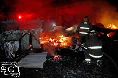
October 9, 2016 - Just as Friday night football games were ending and people were traveling home, the Tenaha Volunteer Fire Department was dispatched to a house fire on FM 947 in Tenaha just past Hickory Lane October 7, 2016.
 The firemen were dispatched just before 9:30pm and when they arrived, the house fire was fully involved. The source and majority of the flames appeared to be emanating from the front of the building.
As the firemen began working to try and put out the fire they requested the assistance of the Timpson Volunteer Fire Department. While the departments worked together to fight the fire, it quickly traveled to the back of the house.

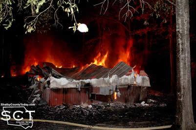
Although efforts were made to save the house, the fire was too advanced to prevent a total loss.
The cause of the fire could not initially be determined. As some first responders arrived on scene, a back door to the house was reported to have been open. The owner of the house, was not at his residence at the time of the fire and had been out of town.
Firemen left the scene and returned to their stations at 11:43pm


October 8, 2016 - Grand Champion - Macade Perry (Center FFA, Senior) - $500 SSB Scholarship - $7,500 bought by Ace Hardware, East Texas Poultry, 4-C Electric
Reserve Grand - Mason Perry (Center FFA) - $2,500 bought by Farmers State Bank
3 - Collin Lloyd (Shelbyville 4-H) - $1,500
4 - Logan Holloway (Center FFA) - $2,499
5 - Konner Windham (Center 4-H) - $2,000
 6 - Kadence Polley (Center 4-H) - $1,200
7 - Megan Dunn (Center 4-H) - $1,600
8 - Levi Birdwell (Center 4-H) - $1,200
9 - Maddox Hutchins (Joaquin FFA) - $1,200
10 - Lance Holloway (Center FFA) - $2,300
11 - Alec Dykes (Center 4-H) - $1,800
12 - Toby Fleming (Center 4-H) - $1,300
13 - Abi Hooper (Joaquin FFA) - $1,300
14 - Hollie Hamilton (Joaquin FFA) - $1,300
15 - Cory McDonald (Tenaha FFA) - $1,200
16 - Justin Hooper (Joaquin FFA) - $1,000
17 - Samuel Richey (Shelbyville 4-H) - $1,500
18 - Baylee Whiteside (Center 4-H) - $1,900
19 - Brynna Birdwell (Center 4-H) - $1,300
20 - Grant Gregory (Center FFA) - $1,600
21 - Dylan Dean (Joaquin FFA) - $2,000
22 - Autumn Webb (Joaquin FFA) - $1,100
23 - Kalie Brooks (Joaquin FFA) - $2,000
24 - Logan Speedy (Center FFA) - $1,200
25 - Aspen Pritchett (Joaquin FFA) - $2,200
26 - Madelynn Hutchins (Joaquin FFA) - $1,600
27 - Zeke Richey (Shelbyville 4-H) - $1,500
28 - Dawson Kay (Shelbyville 4-H) - $1,700
29 - Kaden LaRock (Center FFA) - $1,200
30 - Tyce Scarber (Center 4-H) - $2,499
31 - Mason Barbee (Shelbyville 4-H) - 1,700
32 - Wesley Wages (Center 4-H) - $2,000
33 - Colby Lout (Center 4-H) - $1,800
34 - Ashlynn Lindgren (Timpson FFA) - $2,499
35 - Chance Shuemaker (Joaquin FFA) - $1,100
36 - Anna Holland (Tenaha FFA) - $1,100
37 - Hannah Wages (Center 4-H) - $2,100
38 - Addison Lloyd (Shelbyville 4-H) - $1,500
39 - Deakon Kay (Shelbyville 4-H) - $1,900
40 - Mason Hughes (Joaquin FFA) - $1,500
41 - Brayden Britt (Center 4-H) - $1,300
42 - Collyn Grammer (Center 4-H) - $1,300
43 - Kelsey Adair (Center FFA) - $2,499
44 - Carsen Vickers (Center FFA) - $1,700
45 - Harley Hinton (Shelbyville FFA) - $2,499
 October 8, 2016 (Album1, Album2, Album3) - The 2016 ETPF Broiler Show was held under the tent in front of Farmers State Bank and Alisa Zulkowski Hairston with the Texas A&M University Poultry Science Department sorted the birds into their order for the 4-H & FFA Broiler Show Auction which will be held at 7pm on the Frances Oates Stage.
Out of 82 chicken pens shown, Macade Perry won Grand Champion with his set of birds and his brother Mason Perry won Reserve Champion. Collin Lloyd placed 3rd, Logan Holloway placed 4th, Konner Windham placed 5th, and Kadee Polley placed 6th. To see the rest of the lineup, be sure to come enjoy and participate in the Auction tonight.
October 7, 2016 - When a house fire was discovered at 195 CR 4405 by a neighbor early Friday, October 7 the Center Fire Department responded at 1:03am. The fire was fully involved when the firemen arrived and the majority of the mobile home had burned to the ground.
Fire was threatening to travel into woods surrounding the house and the firemen prevented the flames from traveling any further.
The firemen extinguished the house which was a total loss and SWEPCO responded to the scene to make sure there were no longer any live power lines running to the house.
Property records show the owner of the property to be Jeraldine Pitts and the owner of the mobile home to be Charles Latham.

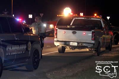
October 7, 2016 - As Panola County deputies engaged in a chase approached Shelby County, assistance was requested from area law enforcement officers in Shelby County.
Officers from agencies including the Shelby County Sheriff's Department, Texas Department of Public Safety and Center Police Department moved in as the chase neared Timpson. Eyewitness accounts near the location of U.S. Highways 84 and 59 stated gunfire was exchanged; however, Sheriff Lake states one shot was fired in an attempt to disable the vehicle after the subject fired and attempted to drive away. That shot was not in an attempt to shoot the subject.

As the officers from Shelby County approached the scene, the suspect involved in the chase had been shot. The Timpson Volunteer Ambulance Service and Timpson Volunteer Fire Department were both dispatched to the scene for traffic control and to treat the injured suspect.
According to a press release from the Panola County Sheriff's Department, a Panola County Deputy attempted to make a traffic stop on a vehicle in the Clayton area for an expired registration which had been expired for over 2 years on October 6, 2016 at 7:56pm.
When the deputy activated his emergency lights, the vehicle failed to stop traveling south on FM 1970. Deputies advised that the vehicle failed to stop at the stop light at state highway 315 continuing to travel south on FM 1970. The vehicle was reported to never exceed 75 mph, but refused to stop. As the pursuit reached the area of the southern Panola County line on FM 1970, Shelby County Sheriff’s Office was notified.
The vehicle continued to proceed into Shelby County. Panola County Sheriff’s units remained behind the fleeing vehicle until Shelby County law enforcement could intercept the pursuit. The vehicle began to make defensive maneuvers by jamming the brakes attempting to crash into the pursuing units. Panola County deputies allowed a safe distance as to not strike the vehicle.
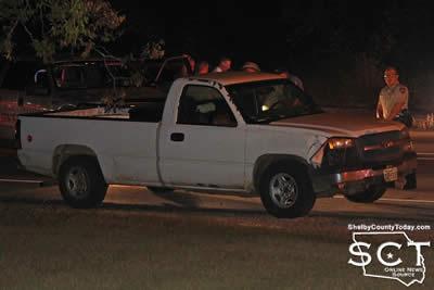
As the vehicle approached the intersection of FM 1970 and FM 84, deputies reported they observed the subject displaying a firearm which appeared to be a rifle or shotgun. As the vehicle stopped at the intersection at US 84, the subject fired one shot from inside the cab of the vehicle then fled again traveling east on US 84.
Deputies reported that the subject continued to display the firearm as he traveled on US 84 towards Timpson. As the vehicle approached US Highway 59, the subject dropped the firearm out the window before finally stopping at the intersection of US highway 59. The subject was taken into custody without further incident.

It was discovered upon making contact with the subject he had a self-inflicted gunshot wound to the face. First aid was administered until Timpson Volunteer EMS arrived on the scene. The subject was transported to a Nacogdoches hospital with non-life threatening injuries.
Sheriff Kevin Lake thanks Panola County Constable Bryan Murff, Shelby County Sheriff’s Office, Center Police Department, Timpson Police Department and Texas DPS for their assistance.
At this time the Panola County Sheriff's Department has not released information pertaining to the identity of the driver.
October 6, 2016 - (Update): The city of Center experienced a large area power outage early Thursday, October 6, 2016 which amongst other things blacked out the Center square.
According to Carey Sullivan, SWEPCO representative, at 5:50am a vehicle hit a guy-wire and broke a utility pole on the main circuit causing an outage effecting 1,474 customers. About 1,000 customers' power was restored by 8am and the remained were back on by 10:50am.
The Center Police Department did not have a record of a crash occurring at that time, and the driver involved apparently fled the scene with the vehicle involved.
(October 6, 2016, 6:45am): A large portion of the city of Center is currently without power due to an outage suspected to involve a transformer.
Use caution on the square as there are no traffic lights functional at the time at that location. Hurst Street traffic lights remain functional; however, Wal Mart is without power and most businesses south of that location until Loop 500.

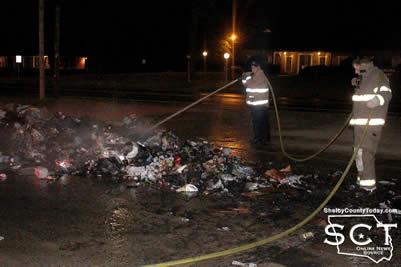
October 6, 2016 - The parking lot of Family Dollar in Center became the staging area of a truck fire early Thursday, October 6, 2016 involving a garbage truck.
Center Fire Department responded to the location at 5:45am where the garbage truck, of which the contents were on fire, had dumped the trash within its hold onto the parking lot of the Family Dollar.
The firemen extinguished the fiery trash heap and Republic Services later cleansed the area where the trash had been piled.

Pages