August 22, 2022 - The National Weather Service issued an updated Flood Watch at 3:03pm on Monday, August 22, 2022 stating the Flood Watch remains in effect through Tuesday evening.
Flooding caused by excessive rainfall continues to be possible for portions of Louisiana and Texas, including the following counties and parishes, in Louisiana, Caldwell, Grant, La Salle, Natchitoches, Sabine and Winn, in Texas, Angelina, Cherokee, Nacogdoches, Sabine, San Augustine and Shelby through Tuesday evening.
August 21, 2022 - At 4:08pm, Sunday, August 21, 2022, the National Weather Service in Shreveport has issued a Severe Thunderstorm Warning for Southwestern Panola County in northeastern Texas, Southeastern Rusk County in northeastern Texas, and Northwestern Shelby County in eastern Texas until 5:00pm.
At 4:08pm, a severe thunderstorm was located 7 miles southeast of Minden, or 18 miles southeast of Henderson, moving northeast at 25 mph.
Radar indicated 60 mph wind gusts and penny size hail. Expect damage to roofs, siding, and trees.
August 21, 2022 - The National Weather Service, Shreveport, Louisiana at 2:31pm, Sunday, August 21, 2022 issued a Flood Watch in effect through Monday evening.
Flooding caused by excessive rainfall is possible for portions of east Texas and northeast Texas, including the following counties, in east Texas, Nacogdoches and Shelby and in northeast Texas, Cherokee.
August 20, 2022 - The National Weather Service, Shreveport, Louisiana, issued a Hazardous Weather Outlook at 1:53pm on Saturday, August 20, 2022 for south central Arkansas, southwest Arkansas, north central Louisiana, northwest Louisiana, southeast Oklahoma, east Texas and northeast Texas.
This afternoon and tonight, rain chances will remain in place across southern portions of the area this afternoon. A few strong storms with gusty winds and frequent lightning cannot be ruled out, along with isolated flash flooding from locally heavy downpours.
Updated at 4:40pm: At 432 PM CDT, Doppler radar was tracking a strong thunderstorm near Joaquin, or 12 miles north of Center, moving northeast at 15 mph.
Updated at 4:25pm: The National Weather Service issued a Special Weather Statement at 4:04pm on Saturday, August 20, 2022. A strong thunderstorms will impact portions of southwestern De Soto Parish, southeastern Panola, Shelby and northeastern San Augustine Counties through 4:30pm CDT.
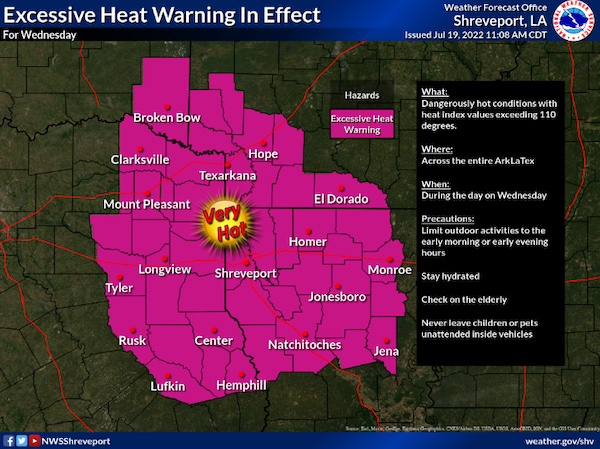
July 20, 2022 - The National Weather Service, Shreveport, LA issued at 3:07am on Wednesday, July 20, 2022 the Excessive Heat Warning remains in effect until 7pm this evening.
July 13, 2022 - The National Weather Service in Shreveport has issued a Severe Thunderstorm Warning for West central De Soto Parish in northwestern Louisiana, Southeastern Panola County in northeastern Texas, North central Shelby County in eastern Texas until 8pm CDT.
At 709 PM CDT, a severe thunderstorm was located near Joaquin, or 12 miles north of Center, and is nearly stationary.