September 25, 2023 - The National Weather Service in Shreveport has issued a Severe Thunderstorm Warning for Southwestern Panola County in northeastern Texas, Southeastern Rusk County in northeastern Texas, Nacogdoches County in eastern Texas, Western Shelby County in eastern Texas, Angelina County in eastern Texas, Northwestern San Augustine County in eastern Texas, Southeastern Cherokee County in northeastern Texas until 12:45am CDT.
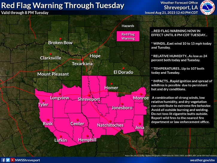
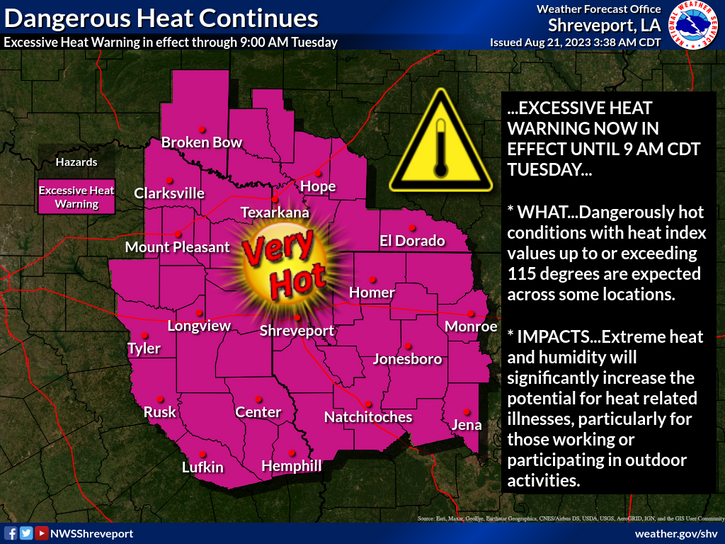
August 21, 2023 - The National Weather Service, Shreveport, LA at 4:50am Monday, August 21, 2023 extended the Excessive Heat Warning until 9am Tuesday.
July 22, 2023 - The National Weather Service in Shreveport has issued a Severe Thunderstorm Warning for Central Sabine Parish in northwestern Louisiana, Southeastern Shelby County in eastern Texas, Northeastern Sabine County in eastern Texas until 6pm CDT.
At 4:55pm CDT, a severe thunderstorm was located 9 miles west of Zwolle, or 24 miles southeast of Center, moving east at 15 mph.
Hazard: 60 mph wind gusts and quarter size hail.
Source: Radar indicated.
Impact: Hail damage to vehicles is expected. Expect wind damage to roofs, siding, and trees.
May 9, 2023 - A strong thunderstorm will impact portions of southern De Soto, southeastern Red River, western Natchitoches and Sabine Parishes, Nacogdoches, Shelby, central Angelina, San Augustine and northern Sabine Counties through 4:30pm CDT.
At 3:33pm CDT, Doppler radar was tracking a strong thunderstorm near Zwolle, or 28 miles north of Toledo Bend Dam, moving north at 25 mph.
Hazard: Winds in excess of 40 mph and half inch hail.
May 5, 2023 - The National Weather Service in Shreveport has issued a Severe Thunderstorm Warning until 1:30am for Panola County in northeastern Texas, Rusk County in northeastern Texas, Nacogdoches County in eastern Texas, Western Shelby County in eastern Texas, Northwestern Angelina County in eastern Texas, Northwestern San Augustine County in eastern Texas, Southeastern Cherokee County in northeastern Texas
At 12:42am CDT, severe thunderstorms were located along a line extending from near Joinerville to Minden to near Trawick to near Forest, moving east at 50 mph.