April 28, 2024 - (Update - 11:14): Tornado Watch 158, previously in effect until 11pm CDT this evening, is now in effect until 1am CDT this evening for the following areas:
In Texas this watch includes five counties in Northeast Texas.
Angelina, Nacogdoches, Sabine, San Augustine, and Shelby.
This includes the cities of Center, Hemphill, Lufkin, Nacogdoches, Pineland, and San Augustine.
(Update - 9:27pm): Tornado Watch 158, previously in effect until 9pm CDT this evening, is now in effect until 11pm CDT this evening for the following areas:
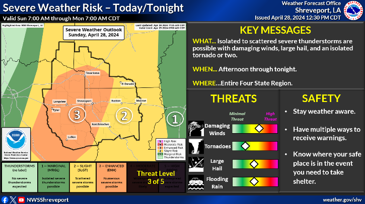
(Update): Severe thunderstorms will be possible across much of the Four State Region this afternoon and tonight. Damaging winds and large hail will be the primary threats, but a few tornadoes can't be ruled out. Also, locally heavy rainfall may result in flash flooding.
April 28, 2024 - (Update - 9:44pm): The National Weather Service in Shreveport has issued a Flash Flood Warning as of 9:05pm for Northwestern Angelina County in eastern Texas, Northern Nacogdoches County in eastern Texas, Northwestern Shelby County in eastern Texas, Southeastern Rusk County in northeastern Texas until midnight CDT tonight.
At 9:05pm CDT, Doppler radar indicated thunderstorms producing heavy rain across the warned area. Flash flooding is ongoing or expected to begin shortly.
April 26, 2024 - This Hazardous Weather Outlook is for south central Arkansas, southwest Arkansas, north central Louisiana, northwest Louisiana, southeast Oklahoma, east Texas and northeast Texas.
Editor's note: Shelby County Today has received reports of heavy weather at 3:20pm in the Timpson area, with heavy debris including bricks becoming an issue on the Timpson square.
April 8, 2024 - (Update: 4:22pm) - A strong thunderstorm will impact northeastern Nacogdoches, southwestern Shelby and northwestern San Augustine counties through 4:45pm CDT.
At 4:08pm CDT, Doppler radar was tracking a strong thunderstorm over Martinsville, or 13 miles east of Nacogdoches, moving northeast at 30 mph.
Hazard: Wind gusts up to 40 mph and pea size hail.

 National Weather Service Radar (8:24pm)