May 16, 2024 - Flood watch remains in effect from 1pm CDT this afternoon (Thursday, May 16) through Friday evening.
What: Flooding caused by excessive rainfall continues to be possible.
Where: Portions of Louisiana, including the following parishes, Bienville, Caldwell, De Soto, Grant, Jackson, La Salle, Natchitoches, Ouachita, Red River, Sabine and Winn and Texas, including the following counties, Angelina, Cherokee, Nacogdoches, Panola, Rusk, Sabine, San Augustine and Shelby.
May 12, 2024 - (Update: 9:09pm): as of 9:01pm, a Flood Warning continues for the following rivers in Texas Attoyac Bayou Near Chireno affecting Rusk, Shelby, San Augustine and Nacogdoches Counties.
For the Attoyac Bayou including Chireno, minor flooding is forecast.
May 9, 2024 - This Hazardous Weather Outlook is for south central Arkansas, southwest Arkansas, north central Louisiana, northwest Louisiana, southeast Oklahoma, east Texas and northeast Texas.
Day One - Today and tonight: Showers and thunderstorms are expected to redevelop this afternoon and evening near the slow moving front, with the severe weather threat for damaging winds, hail and an embedded tornado or two over the region.
May 5, 2024 - This Hazardous Weather Outlook is for portions of south central Arkansas, southwest Arkansas, north central Louisiana, northwest Louisiana, southeast Oklahoma, east Texas and northeast Texas.
Day One: This Afternoon and Tonight, isolated to scattered thunderstorms are expected later this afternoon through at least early this evening. While a stray severe storm cannot be ruled out, the strongest storms will generally have the capability of producing small hail, strong wind gusts, frequent lightning, and locally heavy rainfall.
May 4, 2024 - This Hazardous Weather Outlook is for south central Arkansas,
southwest Arkansas, north central Louisiana, northwest Louisiana,
southeast Oklahoma, east Texas and northeast Texas.
May 2, 2024 - Strong thunderstorms will impact southwestern De Soto parish, southern Panola, southeastern Rusk, eastern Nacogdoches, Shelby, southeastern Angelina, San Augustine and western Sabine counties through 8:45am CDT.
At 7:45am CDT, Doppler radar was tracking a cluster of strong thunderstorms along a line extending from 7 miles west of Timpson to near Melrose to 10 miles southeast of Huntington. Movement was east at 35 mph.
Hazard: Wind gusts up to 50 mph and pea size hail.
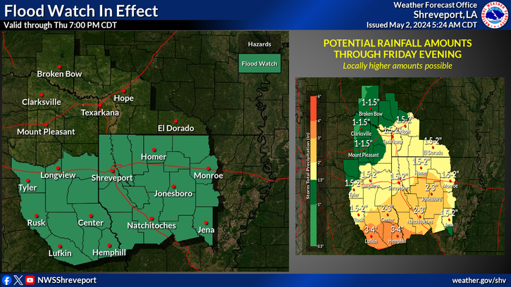
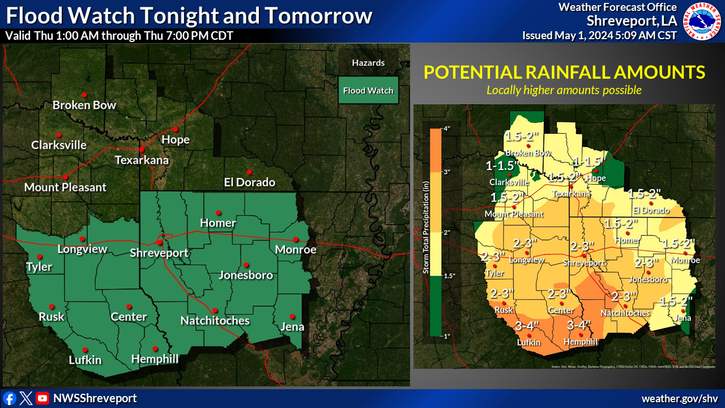
Excessive heavy rainfall is back in the forecast beginning tonight and continuing into tomorrow. Accumulations of 2 to 4 inches are expected. A Flood Watch will be in effect from 1 AM through 7 PM tomorrow.