April 2, 2017 - A flash flood watch is in effect for all of Northwest and North Central Louisiana and portions of East Texas general south of a line from Yantis to Jefferson from 10am Sunday, April 2, 2017 to 7am Monday, April 3, 2017.
A strong springtime storm system will bring the potential for very heavy rainfall rates over a short time period. Despite the lack of recent soaking rains, the high rainfall rates could be too much for soils to handle, which may result in a threat for flash flooding today and into early Monday morning.
5:46pm Update: Isolated showers are expected to gradually increase this evening. Thunderstorms will also begin developing in some area, and a few storms could become strong. This activity will move to the northeast at 30 to 40 mph.
March 29, 2017 - At 9:02am CDT, Wednesday, March 29, 2017 the National Weather Service (NWS) in Shreveport, Louisiana forecast a band of showers and isolated thunderstorms will move northeastward into the area during the mid to late morning. Gusty winds and brief heavy rain are possible.
March 24, 2017 - The National Weather Service in Shreveport has issued a Severe Thunderstorm Warning for Southwestern De Soto Parish in northwestern Louisiana, Northwestern Sabine Parish in northwestern Louisiana, and Eastern Shelby County in eastern Texas until 1015 PM CDT.
At 938 PM CDT, a severe thunderstorm was located near Patroon, or 12 miles southeast of Center, moving northeast at 50 mph.
HAZARD...60 mph wind gusts. SOURCE...Radar indicated. IMPACT...Expect damage to roofs, siding, and trees.
March 24, 2017 - Tornado Watch 82 in in effect until 3am March 25, 2017 for the following counties: Angelina, Cherokee, Nacogdoches, Panola, Rusk, Sabine, San Augustine and Shelby.
Strong to severe thunderstorms will move east across the area. Although damaging wind gusts main threat, tornadoes and large hail also possible. Brief but very heavy rainfall and frequent deadly lighting strikes can be expected as well.
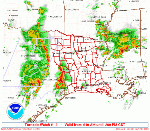
January 21, 2017 - Tornado watch outline update for watch 16 NWS storm prediction center Norman Ok 340pm CST Sat Jan 21 2017 tornado watch 16 is in effect until 9pm cst for the following locations.
Texas counties included are Angelina Bowie Cass Gregg Harrison Marion Morris Nacogdoches Panola Rusk Sabine San Augustine Shelby
January 6, 2017 - Patchy areas of drizzle and sleet are moving to the northeast at 15 mph expect these conditions to continue across the area through the morning hours. Motorist take extra time to get to your destination this morning and remember roadways and elevated surface like bridges could be slick with patchy ice.
National Weather Service, Shreveport, Louisiana
11:00am CST, Sunday, January 1, 2017
January 1, 2017 - The National Weather Service (NWS) has issued a Hazardous Weather Outlook for portions of South Central Arkansas, Southwest Arkansas, North Central Louisiana, Northwest Louisiana, Southeast Oklahoma, East Texas and Northeast Texas.
National Weather Service Shreveport, Louisiana
9:50pm CST, Sunday, January 1, 2017
January 1, 2017 - The National Weather Service (NWS) has issued a dense fog advisory in effect until 6am CST Monday for all of North Louisiana, Southwest Arkansas, McCurtain County Oklahoma, and portions of East Texas.